Atm nearby Al Rajhi ATM
Coronavirus disease (COVID-19) Situation
confirmed cases
841469
deaths
9646
Saudi Arabia
Atm nearby Al Rajhi ATM
Al Rajhi ATM
Prince Nayef Road, Riyadh Saudi Arabia
contacts phone
:
+966
Latitude:
24.7405392
, Longitude:
46.6725585
read more
nearest Atm
74 m
Alinma ATM
7288 Prince Nayef Road, Riyadh
Atm
read more
738 m
Tahweel Al Rajhi
Hisham bin Abdulmalik, King Fahad District, Riyadh
Atm
read more
791 m
SABB
1, Al Hayat Mall, Mini #, Riyadh
Atm
read more
791 m
SABB
3, Al Hayat Mall, Mini #, Riyadh
Atm
read more
791 m
SABB
4, Al Hayat Mall, Mini #, Riyadh
Atm
read more
791 m
SABB
2, Al Hayat Mall, Mini #, Riyadh
Atm
read more
800 m
NCB ATM صراف الأهلي
7905-7993 Al Mughirah Ibn Shubah, Riyadh
Atm
read more
800 m
صراف الأهلي
7905-7993 Al Mughirah Ibn Shubah, Riyadh
Atm
read more
824 m
ساب
الرياض
Atm
read more
918 m
Al Rajhi Bank ATM
Hisham Ibn Abdulmalik, Riyadh
Atm
read more
925 m
Samba ATM
King Abdullah Branch Road, King Fahd، الرياض
Atm
read more
952 m
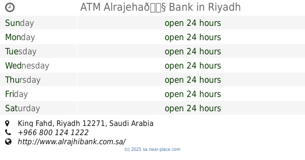
ATM Alrajeha🏧 Bank
Riyadh
Atm
read more
954 m
مصرف الراجحي
طريق الملك عبدالله، حي الملك فهد، الرياض
Atm
read more
959 m
الأهلي
مجمع العودة التجاري السكني، طريق العليا، حي الملك فهد، الرياض
Atm
read more
973 m
Tahweel Al Rajhi
King Abdullah Rd, Riyadh
Atm
read more
974 m
SABB
King Abdullah Rd Drive Up, Riyadh
Atm
read more
981 m
ATM
King Fahd،ریاض
Atm
read more
1.007 km
Anb ATM
7960 King Abdul Aziz Branch Road, Riyadh
Atm
read more
1.008 km
Al Rajhi ATM
King Fahd, Riyadh
Atm
read more
1.012 km
ATM
King Abdullah Branch Road, Riyadh
Atm
read more
1.015 km
alrajhi ATM
طريق الملك عبدالله، الورود،, Riyadh
Atm
read more
1.016 km
٤ مكائن صراف سحب وايداع🏧
Riyadh
Atm
read more
1.028 km
ساب
طريق الملك عبد العزيز - حي الملك فهد، الرياض
Atm
read more
1.034 km
صراف الراجحي
King Abdullah Road, Riyadh
Atm
read more
1.035 km
صراف الراجحي
طريق العليا، حي الملك فهد، الرياض
Atm
read more
📑
all categories
Accounting
Administrative area level 1
Airport
Amusement park
Aquarium
Art gallery
Atm
Bakery
Bank
Bar
Beauty salon
Bicycle store
Book store
Bowling alley
Bus station
Cafe
Campground
Car dealer
Car rental
Car repair
Car wash
Casino
Cemetery
Church
City hall
Clothing store
Colloquial area
Convenience store
Country
Courthouse
Dentist
Department store
Doctor
Electrician
Electronics store
Embassy
Finance
Fire station
Florist
Food
Funeral home
Furniture store
Gas station
General contractor
Grocery or supermarket
Gym
Hair care
Hardware store
Health
Hindu Temple
Home goods store
Hospital
Insurance agency
Intersection
Jewelry store
Laundry
Lawyer
Library
Light rail station
Liquor store
Local government office
Locality
Locksmith
Lodging
Meal delivery
Meal takeaway
Mosque
Movie rental
Movie theater
Moving company
Museum
Natural feature
Neighborhood
Night club
Painter
Park
Parking
Pet store
Pharmacy
Physiotherapist
Place of worship
Plumber
Point of interest
Police
Political
Post office
Premise
Real estate agency
Restaurant
Roofing contractor
Route
Rv park, camping
School
Shoe store
Shopping mall
Spa
Stadium
Storage
Store
Sublocality
Subpremise
Subway station
Supermarket
Taxi stand
Train station
Transit station
Travel agency
University
Veterinary care
Zoo
sublocality level 1
↑