Atm nearby الأهلي
Coronavirus disease (COVID-19) Situation
confirmed cases
841469
deaths
9646
Saudi Arabia
Atm nearby الأهلي
الأهلي
طريق النقع، حي النقع، بريدة Saudi Arabia
contacts phone
:
+966
Latitude:
26.3447965
, Longitude:
43.9902918
read more
nearest Atm
952 m
صراف الأهلي🏧
2317 التغيرة، المطار القديم، بريدة 52362 8220 At Taghirah, Buraydah
Atm
read more
1.027 km
Al Rajhi ATM
8316 King Khalid Road, Buraydah
Atm
read more
1.04 km
NCB ATM
2418 طريق الملك خالد، المطار القديم بريدة 52362 7407 King Khalid Road, Buraydah
Atm
read more
1.431 km
Alinma ATM
King Khalid Road, Buraydah
Atm
read more
1.76 km
Al Rajhi ATM
At Taghirah, Buraydah
Atm
read more
1.79 km
مصرف الراجحي
النقع الشرقي، طريق التغيرة، بريدة
Atm
read more
1.951 km
صراف الأهلي
4762 An Naqa, Buraydah
Atm
read more
1.961 km
بنك الرياض
طريق عمر بن عبدالعزيز، حي الملك، بريدة
Atm
read more
2.011 km
Riyad ATM
Umar Ibn Abdul Aziz Road, Buraydah
Atm
read more
2.12 km
Riyad ATM
7002 An Naqa, Buraydah
Atm
read more
2.152 km
ANB ATM
Buraydah
Atm
read more
2.18 km
Riyad ATM
6991 King Khalid Road, Buraydah
Atm
read more
2.232 km
Riyad ATM
Al Imarah, Buraydah
Atm
read more
2.336 km
Albilad ATM
King Khalid Road, Buraydah
Atm
read more
2.36 km
SABB
Al Mahakem Drive Up, Buraydah
Atm
read more
2.366 km
SABB ATM
8398 King Khalid Road, Buraydah
Atm
read more
2.367 km
NCB ATM
King Khalid Road, Buraydah
Atm
read more
2.407 km
Riyad ATM
3380 Umar Ibn Abdul Aziz Road, Buraydah
Atm
read more
2.436 km
Al Rajhi ATM
4897 طريق الرياض القديم, Buraydah
Atm
read more
2.459 km
Cambio Buraydha
6887-6906 King Abdulaziz Road, Buraydah
Atm
read more
2.464 km
Tahweel Al Rajhi
king abdulaziz road, Buraida, Buraydah
Atm
read more
2.465 km
Al Rajhi ATM
8726 طريق الملك عبد العزيز بريدة 52355 3700 King Abdulaziz Road, Buraydah
Atm
read more
2.476 km
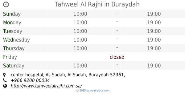
Tahweel Al Rajhi
center hospetal, Al Sadah, Buraydah
Atm
read more
2.482 km
Tahweel Al Rajhi
king abdulaziz, King Abdalaziz Rd, Buraydah
Atm
read more
2.484 km
NCB 2359 328
8394 King Abdulaziz Road, Buraydah
Atm
read more
📑
all categories
Accounting
Administrative area level 1
Airport
Amusement park
Aquarium
Art gallery
Atm
Bakery
Bank
Bar
Beauty salon
Bicycle store
Book store
Bowling alley
Bus station
Cafe
Campground
Car dealer
Car rental
Car repair
Car wash
Casino
Cemetery
Church
City hall
Clothing store
Colloquial area
Convenience store
Country
Courthouse
Dentist
Department store
Doctor
Electrician
Electronics store
Embassy
Finance
Fire station
Florist
Food
Funeral home
Furniture store
Gas station
General contractor
Grocery or supermarket
Gym
Hair care
Hardware store
Health
Hindu Temple
Home goods store
Hospital
Insurance agency
Intersection
Jewelry store
Laundry
Lawyer
Library
Light rail station
Liquor store
Local government office
Locality
Locksmith
Lodging
Meal delivery
Meal takeaway
Mosque
Movie rental
Movie theater
Moving company
Museum
Natural feature
Neighborhood
Night club
Painter
Park
Parking
Pet store
Pharmacy
Physiotherapist
Place of worship
Plumber
Point of interest
Police
Political
Post office
Premise
Real estate agency
Restaurant
Roofing contractor
Route
Rv park, camping
School
Shoe store
Shopping mall
Spa
Stadium
Storage
Store
Sublocality
Subpremise
Subway station
Supermarket
Taxi stand
Train station
Transit station
Travel agency
University
Veterinary care
Zoo
sublocality level 1
↑