Atm nearby Bank Aljazira
Coronavirus disease (COVID-19) Situation
confirmed cases
841469
deaths
9646
Saudi Arabia
Atm nearby Bank Aljazira
Bank Aljazira
At Tasni, 23523, Jeddah, SA Saudi Arabia
contacts phone
:
+966
website:
www.baj.com.sa
Latitude:
21.6176493
, Longitude:
39.1345731
larger map & directions
read more
nearest Atm
464 m
SABB ATM 🏧
Prince Sultan Road, Jeddah
Atm
read more
886 m
SABB
Alnahda district Lobby, Jeddah
Atm
read more
1.016 km
Al Rajhi ATM 🏧
Hira Street, Jeddah
Atm
read more
1.083 km
Bank Al Jazira ATM
Hira Street, Jeddah
Atm
read more
1.102 km
صراف الجزيرة
شارع حراء، حي النهضة، جدة
Atm
read more
1.111 km
Bank Al Bilad ATM 🏧
Hira Street, Jeddah
Atm
read more
1.131 km
SABB
ALSHRA GAS STATION, Jeddah
Atm
read more
1.142 km
SABB ATM Al Salamah District
2597 حراء،، As Salamah District، Jeddah، 23525
Atm
read more
1.183 km
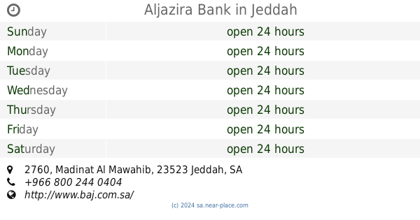
Aljazira Bank
2760 Madinat Al Mawahib, An Nahdah District,, Jeddah
Atm
read more
1.224 km
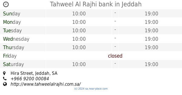
Tahweel Al Rajhi bank
Fruit Boat Sculpture, Hira Street, Jeddah
Atm
read more
1.236 km
ATM الراجحي
3143 حراء, حي الزهراء, Jeddah
Atm
read more
1.249 km
Riyad Bank
2792 حراء, حي النعيم, Jeddah
Atm
read more
1.264 km
Al Rajhi ATM
7524 Prince Sultan Road, An Nahdah District 5418, Jeddah
Atm
read more
1.301 km
صراف الأهلي NCB
جدة
Atm
read more
1.309 km
صراف البنك الأهلي NCB
Jeddah
Atm
read more
1.309 km
Fransi ATM
Al Manahij, Jeddah
Atm
read more
1.31 km
NCB ATM
جدة
Atm
read more
1.358 km
الراجحي للتأمين
7630 Prince Sultan Road, حي النهضة 5378, Jeddah
Atm
read more
1.384 km
SABB
Al-Mokhtar Center, Jed, Jeddah
Atm
read more
1.437 km
البنك السعودي الفرنسي
شارع حراء، حي النعيم، جدة
Atm
read more
1.483 km
Al-Rajhi ATM
3072 حراء, Jeddah
Atm
read more
1.539 km
مصرف الإنماء
شارع حراء، حي الزهرة، جدة
Atm
read more
1.539 km
صراف الإنماء
شارع حراء، حي الزهرة، جدة
Atm
read more
1.559 km
Aljazira ATM
Ahmad Ibn Usayb, Jeddah
Atm
read more
1.578 km
NCB ATM
3198 حراء, An Naim District, 8153, Jeddah
Atm
read more
📑
all categories
Accounting
Administrative area level 1
Airport
Amusement park
Aquarium
Art gallery
Atm
Bakery
Bank
Bar
Beauty salon
Bicycle store
Book store
Bowling alley
Bus station
Cafe
Campground
Car dealer
Car rental
Car repair
Car wash
Casino
Cemetery
Church
City hall
Clothing store
Colloquial area
Convenience store
Country
Courthouse
Dentist
Department store
Doctor
Electrician
Electronics store
Embassy
Finance
Fire station
Florist
Food
Funeral home
Furniture store
Gas station
General contractor
Grocery or supermarket
Gym
Hair care
Hardware store
Health
Hindu Temple
Home goods store
Hospital
Insurance agency
Intersection
Jewelry store
Laundry
Lawyer
Library
Light rail station
Liquor store
Local government office
Locality
Locksmith
Lodging
Meal delivery
Meal takeaway
Mosque
Movie rental
Movie theater
Moving company
Museum
Natural feature
Neighborhood
Night club
Painter
Park
Parking
Pet store
Pharmacy
Physiotherapist
Place of worship
Plumber
Point of interest
Police
Political
Post office
Premise
Real estate agency
Restaurant
Roofing contractor
Route
Rv park, camping
School
Shoe store
Shopping mall
Spa
Stadium
Storage
Store
Sublocality
Subpremise
Subway station
Supermarket
Taxi stand
Train station
Transit station
Travel agency
University
Veterinary care
Zoo
sublocality level 1
↑