Atm nearby NCB ATM 🏧
Saudi Arabia
Atm nearby NCB ATM 🏧
NCB ATM 🏧
Asmaa Bint Abu Bakr, 23449, Jeddah, SA Saudi Arabia
contacts phone
:
+966 9200 01000
website:
www.alahli.com
Latitude:
21.5941701
, Longitude:
39.187874
larger map & directions
read more
nearest Atm
252 m
Bank aljazira
7473 المكرونة, AR Rabwah District, Jeddah
Atm
read more
390 m
صراف البنك الأهلي التجاري
Al Makarunah Road, Jeddah
Atm
read more
661 m
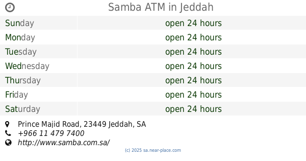
Samba ATM
Prince Majid Road, Jeddah
Atm
read more
665 m
Al Rajhi Bank ATM Drive Thru 🏧
Jeddah
Atm
read more
740 m
مصرف الراجحي
طريق الأميرماجد، جدة
Atm
read more
849 m
صراف البنك السعودي للإستثمار
8345 المكرونة, حي الربوة، 4438, Jeddah
Atm
read more
935 m
SABB
ALJ - TOYOTA - NGFC, Jeddah
Atm
read more
1.046 km
NCB ATM 🏧
Muhammad Ibn Muslimah, Jeddah
Atm
read more
1.061 km
Banque Saudi Fransi ATM
Sari, Jeddah
Atm
read more
1.088 km
البنك السعودي الفرنسي
جدة
Atm
read more
1.103 km
Alinma ATM
Sari, Jeddah
Atm
read more
1.163 km
SABB
Sary Street Drive Up, Jeddah
Atm
read more
1.165 km
SABB ATM
Sari, Jeddah
Atm
read more
1.169 km
بنك الرياض
شارع الثلاثين ، الربوة، جدة
Atm
read more
1.176 km
The Saudi Ivestment Bank
Al Makarunah Branch, Jeddah
Atm
read more
1.205 km
صراف البنك السعودي للاستثمار
Jeddah
Atm
read more
1.353 km
Riyad Bank ATM 🏧
2805 ibn At Tarabulsi, As Safa District, Jeddah
Atm
read more
1.353 km
صراف بنك الرياض
2805 ibn At Tarabulsi, As Safa District, Jeddah
Atm
read more
1.403 km
SABB
Street 30 TTW Lobby, Jeddah
Atm
read more
1.476 km
الأهلي
شارع صالح الشرطوني، جدة
Atm
read more
1.504 km
بنك الجزيرة
شارع الامير ماجد ، الصفا، جدة
Atm
read more
1.51 km
البنك السعودي الفرنسي
طريق الملك فهد، حي البوادي، جدة
Atm
read more
1.542 km
صراف الرياض
7686 King Fahd Road, حي البوادي, Jeddah
Atm
read more
1.652 km
Al Rajhi ATM🏧
Prince Mutaib bin Abdulaziz Road, Jeddah
Atm
read more
1.676 km
صراف بنك الأهلي
جدة
Atm
read more
📑
all categories
Accounting
Administrative area level 1
Airport
Amusement park
Aquarium
Art gallery
Atm
Bakery
Bank
Bar
Beauty salon
Bicycle store
Book store
Bowling alley
Bus station
Cafe
Campground
Car dealer
Car rental
Car repair
Car wash
Casino
Cemetery
Church
City hall
Clothing store
Colloquial area
Convenience store
Country
Courthouse
Dentist
Department store
Doctor
Electrician
Electronics store
Embassy
Finance
Fire station
Florist
Food
Funeral home
Furniture store
Gas station
General contractor
Grocery or supermarket
Gym
Hair care
Hardware store
Health
Hindu Temple
Home goods store
Hospital
Insurance agency
Intersection
Jewelry store
Laundry
Lawyer
Library
Light rail station
Liquor store
Local government office
Locality
Locksmith
Lodging
Meal delivery
Meal takeaway
Mosque
Movie rental
Movie theater
Moving company
Museum
Natural feature
Neighborhood
Night club
Painter
Park
Parking
Pet store
Pharmacy
Physiotherapist
Place of worship
Plumber
Point of interest
Police
Political
Post office
Premise
Real estate agency
Restaurant
Roofing contractor
Route
Rv park, camping
School
Shoe store
Shopping mall
Spa
Stadium
Storage
Store
Sublocality
Subpremise
Subway station
Supermarket
Taxi stand
Train station
Transit station
Travel agency
University
Veterinary care
Zoo
sublocality level 1
↑