Atm nearby صراف البنك الاول
Coronavirus disease (COVID-19) Situation
confirmed cases
841469
deaths
9646
Saudi Arabia
Atm nearby صراف البنك الاول
صراف البنك الاول
Abonyan Sultan Hospital humanity- Qassim Rd.، الرياض Saudi Arabien
contacts phone
:
+966
Latitude:
24.9899221
, Longitude:
46.5230626
read more
nearest Atm
79 m
البنك الاول
Riyadh
Atm
read more
235 m
SABB
Al Qassim Road, Banban، الرياض
Atm
read more
250 m
Al Awal ATM
Riyadh
Atm
read more
310 m
AlAwwal ATM
Riyadh
Atm
read more
6.745 km
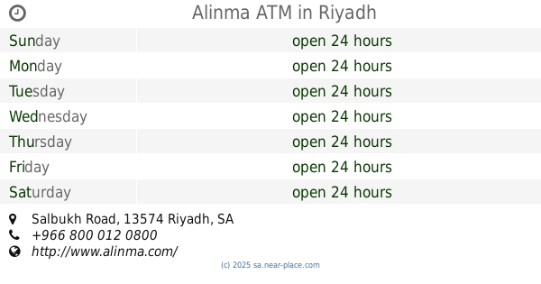
Alinma ATM
Salbukh Road, Riyadh
Atm
read more
13.371 km
صراف الاهلي NCB ATM
Riyadh
Atm
read more
14.235 km
SABB
Al-Atlal Gas station (36-130771, Riyadh
Atm
read more
15.558 km
Al-Rajih ATM Machine
Riyadh
Atm
read more
15.563 km
صراف آلي مصرف الراجحي🏧
Riyadh
Atm
read more
16.503 km
ATM Al-Rajhi Bank
King Fahd Branch Road, Riyadh
Atm
read more
16.505 km
صراف الراجحي🏧
King Fahd Road, Riyadh
Atm
read more
16.667 km
Albilad
King Abdulaziz Road, Riyadh
Atm
read more
17.197 km
صراف بنك الانماء
طريق الملك عبدالعزيز،، الرياض
Atm
read more
17.22 km
Alahli Bank
Riyadh
Atm
read more
17.818 km
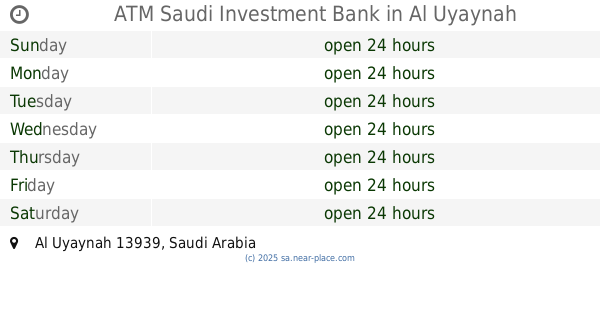
ATM Saudi Investment Bank
Al Uyaynah
Atm
read more
18.13 km
Alinma's Bank ATM
Riyadh
Atm
read more
18.434 km
Rajhi ATM
Riyadh
Atm
read more
18.547 km
Alrajhi ATM
Abi Bakr As Siddiq Road, Riyadh
Atm
read more
18.662 km
صراف البنك العربي
Riyadh
Atm
read more
18.666 km
Riyad Bank
شارع الأمير سعود بن عبدالله بن جلوي، حي النرجس، الرياض
Atm
read more
18.666 km
بنك الرياض
شارع الأمير سعود بن عبدالله بن جلوي، حي النرجس، الرياض
Atm
read more
18.684 km
Riyad Bank ATM
Prince Saud Ibn Abdullah Ibn Jalawi, Riyadh
Atm
read more
19.318 km
ATM Alawal Bank & Bank Saudi Fransi
3126, Riyadh
Atm
read more
19.334 km
صراف البنك الاول
العارض،، الرياض
Atm
read more
19.335 km
Al bustan Village
Riyadh
Atm
read more
📑
all categories
Accounting
Administrative area level 1
Airport
Amusement park
Aquarium
Art gallery
Atm
Bakery
Bank
Bar
Beauty salon
Bicycle store
Book store
Bowling alley
Bus station
Cafe
Campground
Car dealer
Car rental
Car repair
Car wash
Casino
Cemetery
Church
City hall
Clothing store
Colloquial area
Convenience store
Country
Courthouse
Dentist
Department store
Doctor
Electrician
Electronics store
Embassy
Finance
Fire station
Florist
Food
Funeral home
Furniture store
Gas station
General contractor
Grocery or supermarket
Gym
Hair care
Hardware store
Health
Hindu Temple
Home goods store
Hospital
Insurance agency
Intersection
Jewelry store
Laundry
Lawyer
Library
Light rail station
Liquor store
Local government office
Locality
Locksmith
Lodging
Meal delivery
Meal takeaway
Mosque
Movie rental
Movie theater
Moving company
Museum
Natural feature
Neighborhood
Night club
Painter
Park
Parking
Pet store
Pharmacy
Physiotherapist
Place of worship
Plumber
Point of interest
Police
Political
Post office
Premise
Real estate agency
Restaurant
Roofing contractor
Route
Rv park, camping
School
Shoe store
Shopping mall
Spa
Stadium
Storage
Store
Sublocality
Subpremise
Subway station
Supermarket
Taxi stand
Train station
Transit station
Travel agency
University
Veterinary care
Zoo
sublocality level 1
↑