Bakery nearby Sanabil Alsalam
Coronavirus disease (COVID-19) Situation
confirmed cases
841469
deaths
9646
Saudi Arabia
Bakery nearby Sanabil Alsalam
Sanabil Alsalam
Baljurashi Saudi Arabia
contacts phone
:
+966
Latitude:
19.8608826
, Longitude:
41.5703988
read more
nearest Bakery
35 m
Tal Sweet
Baljurashi
Bakery
read more
836 m
الكبه الحجازية
Baljurashi
Bakery
read more
19.304 km
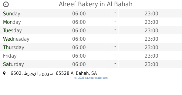
Alreef Bakery
6602 طريق الجنوب, Al Bahah
Bakery
read more
20.178 km
مخابز روعه
7054, Towen Center, Al Bahah
Bakery
read more
20.365 km
Velvet Cupcake
طريق الملك فيصل, Al Bahah
Bakery
read more
20.44 km
تميس النخيل
Saudi Arabia
Bakery
read more
20.529 km
Pizza Rayyan
King Abdulaziz Road, Al Bahah
Bakery
read more
20.554 km
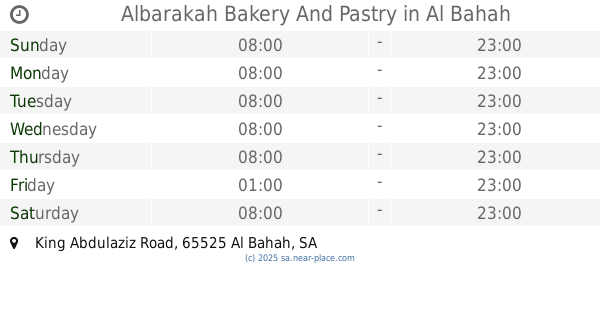
Albarakah Bakery And Pastry
King Abdulaziz Road, Al Bahah
Bakery
read more
20.909 km
Solo
King Fahd Road, Al Bahah
Bakery
read more
24.053 km
HOUSE OF PASTRY
1 King Abdulaziz Road, RAGHDAN TOURIST RESORT, RAGHDAN, Al Bahah
Bakery
read more
96.001 km
معجنات البندر
Al Qunfudhah
Bakery
read more
96.137 km
Bakery
Al Qunfudhah
Bakery
read more
96.167 km
مخابز ابن البلد
Al Qunfudhah
Bakery
read more
96.179 km
مخابز وسوبرماركت الحازمي
Al Qunfudhah
Bakery
read more
96.186 km
حلويات الحازمي
Al Qunfudhah
Bakery
read more
96.408 km
مخبز الأجيال
Al Qunfudhah
Bakery
read more
97.102 km
الاياد للحلويات والحفلات
Al Qunfudhah
Bakery
read more
97.295 km
Cinnabon
King Fahd Ibn Abdul Aziz R, Al Qunfudhah
Bakery
read more
108.276 km
Shake & Cake
3200 شارع ابها، بيشة
Bakery
read more
109.515 km
مخبز عاشور
الفهد،, Bisha
Bakery
read more
109.883 km
الحصيد
شارع بلدية, قرب نادي النخيل، بيشة
Bakery
read more
113.529 km
محل تميس
Bisha
Bakery
read more
138.798 km
Al Raheef Bakery
Ikrimah Bin Abi Jahl, Al Lith
Bakery
read more
138.803 km
مخبز رهيف
Ikrimah Bin Abi Jahl, Al Lith
Bakery
read more
193.012 km
مخبز ميسان
Taif
Bakery
read more
📑
all categories
Accounting
Administrative area level 1
Airport
Amusement park
Aquarium
Art gallery
Atm
Bakery
Bank
Bar
Beauty salon
Bicycle store
Book store
Bowling alley
Bus station
Cafe
Campground
Car dealer
Car rental
Car repair
Car wash
Casino
Cemetery
Church
City hall
Clothing store
Colloquial area
Convenience store
Country
Courthouse
Dentist
Department store
Doctor
Electrician
Electronics store
Embassy
Finance
Fire station
Florist
Food
Funeral home
Furniture store
Gas station
General contractor
Grocery or supermarket
Gym
Hair care
Hardware store
Health
Hindu Temple
Home goods store
Hospital
Insurance agency
Intersection
Jewelry store
Laundry
Lawyer
Library
Light rail station
Liquor store
Local government office
Locality
Locksmith
Lodging
Meal delivery
Meal takeaway
Mosque
Movie rental
Movie theater
Moving company
Museum
Natural feature
Neighborhood
Night club
Painter
Park
Parking
Pet store
Pharmacy
Physiotherapist
Place of worship
Plumber
Point of interest
Police
Political
Post office
Premise
Real estate agency
Restaurant
Roofing contractor
Route
Rv park, camping
School
Shoe store
Shopping mall
Spa
Stadium
Storage
Store
Sublocality
Subpremise
Subway station
Supermarket
Taxi stand
Train station
Transit station
Travel agency
University
Veterinary care
Zoo
sublocality level 1
↑