Bank nearby AlAhli Bank
Coronavirus disease (COVID-19) Situation
confirmed cases
841469
deaths
9646
Saudi Arabia
Bank nearby AlAhli Bank
AlAhli Bank
Al Qunfudhah 28821, Saudi Arabia
contacts phone
:
+966 9200 01000
website:
www.alahli.com
Latitude:
19.1249496
, Longitude:
41.0844771
larger map & directions
read more
nearest Bank
159 m
Western Union | Money Transfer
Al Qunfudhah
Bank
read more
299 m
كويك باي القنفذه
شارع الهاتف, Al Qunfudhah
Bank
read more
315 m
NCB Quikpay
Al Qunfudhah
Bank
read more
328 m
AlRajhi Bank
Al Qunfudhah
Bank
read more
525 m
Bank Albilad
Al Qunfudhah
Bank
read more
721 m
Arab National Bank
5, Al Qunfudhah
Bank
read more
1.141 km
بنك التنمية الاجتماعية - فرع القنفذة
Al Qunfudhah
Bank
read more
87.773 km
مسجد حي وسيع
Bank
read more
90.947 km
Barik Muzmail Cheema
King Abdullah Road, Bariq
Bank
read more
92.6 km
صراف الراجحي
Bariq
Bank
read more
92.6 km
مصرف الراجحي
Bariq
Bank
read more
93.525 km
بنك الاهلي
Bariq
Bank
read more
95.832 km
quick pay
Baljurashi
Bank
read more
95.875 km
تحويل الراحجي
Baljurashi
Bank
read more
96.081 km
جبل سخدن
Bank
read more
96.173 km
Riyad Bank
طريق الملك سعود, Baljurashi
Bank
read more
96.185 km
صراف الأهلي
Baljurashi
Bank
read more
96.518 km
صرافة الرياض
Baljurashi
Bank
read more
96.61 km
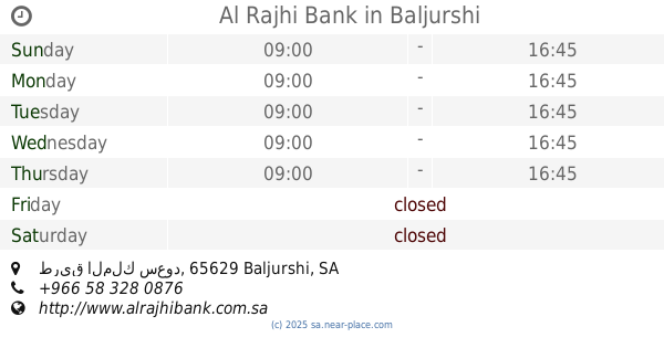
Al Rajhi Bank
طريق الملك سعود, Baljurashi
Bank
read more
96.868 km
National Commercial Bank
3250, السوق - شارع الملك عبد العزيز, Baljurashi
Bank
read more
97.863 km
Arab National Bank
Baljurashi
Bank
read more
97.865 km
Arab National Bank
King Abdulaziz Road, Baljurashi
Bank
read more
105.494 km
البنك السعودي للتسليف والإدخار
طريق الملك فيصل،, Al Bahah
Bank
read more
105.788 km
Alinma Bank
King Saud Road, Al Bahah
Bank
read more
106.047 km
Arab Bank in Al-Baha
7103 زهير بن ابي سلمى, وسط المدينة،, Al Bahah
Bank
read more
📑
all categories
Accounting
Administrative area level 1
Airport
Amusement park
Aquarium
Art gallery
Atm
Bakery
Bank
Bar
Beauty salon
Bicycle store
Book store
Bowling alley
Bus station
Cafe
Campground
Car dealer
Car rental
Car repair
Car wash
Casino
Cemetery
Church
City hall
Clothing store
Colloquial area
Convenience store
Country
Courthouse
Dentist
Department store
Doctor
Electrician
Electronics store
Embassy
Finance
Fire station
Florist
Food
Funeral home
Furniture store
Gas station
General contractor
Grocery or supermarket
Gym
Hair care
Hardware store
Health
Hindu Temple
Home goods store
Hospital
Insurance agency
Intersection
Jewelry store
Laundry
Lawyer
Library
Light rail station
Liquor store
Local government office
Locality
Locksmith
Lodging
Meal delivery
Meal takeaway
Mosque
Movie rental
Movie theater
Moving company
Museum
Natural feature
Neighborhood
Night club
Painter
Park
Parking
Pet store
Pharmacy
Physiotherapist
Place of worship
Plumber
Point of interest
Police
Political
Post office
Premise
Real estate agency
Restaurant
Roofing contractor
Route
Rv park, camping
School
Shoe store
Shopping mall
Spa
Stadium
Storage
Store
Sublocality
Subpremise
Subway station
Supermarket
Taxi stand
Train station
Transit station
Travel agency
University
Veterinary care
Zoo
sublocality level 1
↑