Cafe nearby Baskin Robbins
Coronavirus disease (COVID-19) Situation
confirmed cases
841469
deaths
9646
Saudi Arabia
Cafe nearby Baskin Robbins
Baskin Robbins
مكة 24291, Saudi-Arabien
contacts phone
:
+966
Latitude:
21.3562466
, Longitude:
40.1149423
larger map & directions
read more
nearest Cafe
8.394 km
Bonnon Coffee
15
Cafe
read more
8.4 km
مقهى أجيالنا
Mecca
Cafe
read more
8.459 km
ديوانية الأصالة
محطه العيدروس
Cafe
read more
9.513 km
Emmy's - ايميز
Saudi Arabia
Cafe
read more
10.333 km
Cafe Walker
Mecca
Cafe
read more
15.017 km
قهوة المسافر
Mecca
Cafe
read more
15.476 km
قوات الامن الخاصة عرفات
Unnamed Road, Mecca
Cafe
read more
15.846 km
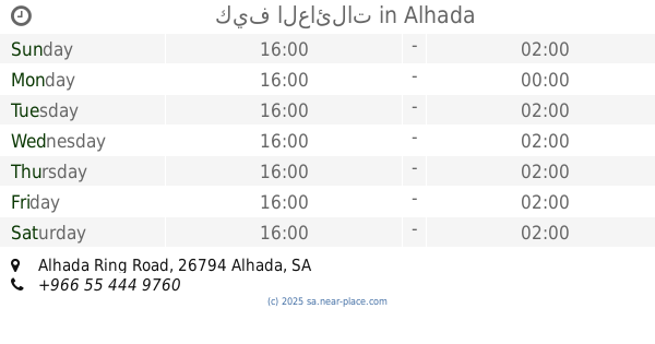
Ramada Alhada coffee
3905, At Taif
Cafe
read more
15.97 km
جاردن كافيه
9217 الهدا الطائف 26794
Cafe
read more
16.053 km
Rawabi Al Hada Cafe
Alhada Road, Alhada
Cafe
read more
16.06 km
Cafe & Casino
4069, At Taif
Cafe
read more
16.078 km
Nayef coffee and tea Paljmr
Alhada
Cafe
read more
16.185 km
سوفليه شهار
Taif
Cafe
read more
16.325 km
كيف العائلات
Alhada Ring Road, Alhada
Cafe
read more
16.356 km
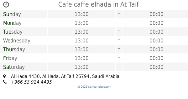
Cafe caffe elhada
8341, Al Hada 4430, At Taif
Cafe
read more
16.519 km
Almahawkh brown for tea and coffee
Alhada
Cafe
read more
16.535 km
How Venjal
الهدا 2250, الطائف
Cafe
read more
16.642 km
Diwaniya Ekazih Coffee Arab section II
Alhada
Cafe
read more
17.188 km
Coffee Nights resort
Alhada Ring Road, Alhada
Cafe
read more
17.23 km
dunkin donuts
مكة
Cafe
read more
17.247 km
ترانزيت كافيه
3652, Mecca
Cafe
read more
17.247 km
Transit Cafe - Umm Al Qura University Abdiah
3652, Mecca
Cafe
read more
17.453 km
Brunchys 3
Mecca
Cafe
read more
17.527 km
مقهى وإستراحة الرياض
الراشدية، مكة
Cafe
read more
17.844 km
Nakhat Ghazal
6498 Arafat Ash Sharaiyaa Rd, Ar Rashidiyyah, Mecca 24275 5863 Arafat Ash Sharaiyaa Road, Mecca
Cafe
read more
📑
all categories
Accounting
Administrative area level 1
Airport
Amusement park
Aquarium
Art gallery
Atm
Bakery
Bank
Bar
Beauty salon
Bicycle store
Book store
Bowling alley
Bus station
Cafe
Campground
Car dealer
Car rental
Car repair
Car wash
Casino
Cemetery
Church
City hall
Clothing store
Colloquial area
Convenience store
Country
Courthouse
Dentist
Department store
Doctor
Electrician
Electronics store
Embassy
Finance
Fire station
Florist
Food
Funeral home
Furniture store
Gas station
General contractor
Grocery or supermarket
Gym
Hair care
Hardware store
Health
Hindu Temple
Home goods store
Hospital
Insurance agency
Intersection
Jewelry store
Laundry
Lawyer
Library
Light rail station
Liquor store
Local government office
Locality
Locksmith
Lodging
Meal delivery
Meal takeaway
Mosque
Movie rental
Movie theater
Moving company
Museum
Natural feature
Neighborhood
Night club
Painter
Park
Parking
Pet store
Pharmacy
Physiotherapist
Place of worship
Plumber
Point of interest
Police
Political
Post office
Premise
Real estate agency
Restaurant
Roofing contractor
Route
Rv park, camping
School
Shoe store
Shopping mall
Spa
Stadium
Storage
Store
Sublocality
Subpremise
Subway station
Supermarket
Taxi stand
Train station
Transit station
Travel agency
University
Veterinary care
Zoo
sublocality level 1
↑