Cafe nearby Cafe and restaurant my days
Coronavirus disease (COVID-19) Situation
confirmed cases
841469
deaths
9646
Saudi Arabia
Cafe nearby Cafe and restaurant my days
Cafe and restaurant my days
Al-Zahra'a, Jeddah 23522, Saudi Arabia
contacts phone
:
+966 12 639 3954
Latitude:
21.6024448
, Longitude:
39.1329229
larger map & directions
read more
nearest Cafe
16 m
DonutMagic
3567 Khalil Bik Al Ajjan, AZ Zahra District,, Jeddah
Cafe
read more
454 m
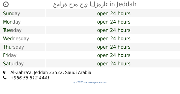
عمارة جده حي الزهراء
Jeddah
Cafe
read more
554 m
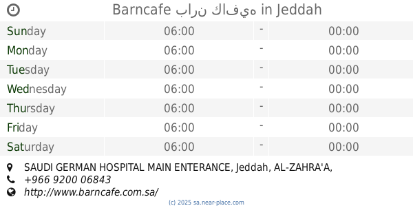
Barncafe بارن كافيه
SAUDI GERMAN HOSPITAL MAIN ENTERANCE, Jeddah, AL-ZAHRA'A, الزهراء - شارع البترجي, المستشفى السعودي الالماني, Jeddah
Cafe
read more
672 m
إستا كافيه
البترجي، الزهراء،, Jeddah
Cafe
read more
673 m
طرمبه بالنوتيلا
Al Batarji Branch, Jeddah
Cafe
read more
698 m
Esta Cafe - استا كافيه
Jeddah
Cafe
read more
701 m
Chill Cafe
4094 Al Batarji, حي الزهراء, Jeddah
Cafe
read more
712 m
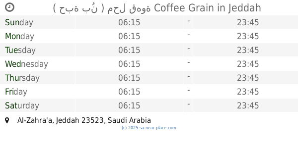
( حبة بُن ) محل قهوة Coffee Grain
Jeddah
Cafe
read more
712 m
تشمني كيك
4068 Al Batarji, حي الزهراء, Jeddah
Cafe
read more
715 m
Platina cafee Donatroo
Jeddah
Cafe
read more
715 m
Platina Cafee
21 Saudi Arabia، Parañaque
Cafe
read more
726 m
الزهراء.جدة
Jeddah
Cafe
read more
746 m
Khan Murjan
Al Batarji Branch, Al-Zahra'a، جدة
Cafe
read more
778 m
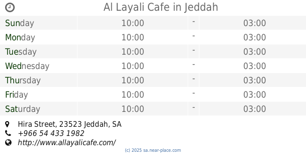
Al Layali Cafe
Hira Street, Jeddah
Cafe
read more
807 m
Zain' s cookies
21°35'50.4"N 39°08'19.3"E
Cafe
read more
811 m
شاهي عالحطب
Jeddah
Cafe
read more
814 m
ايس كريم كوليتي
2959 حراء، حي الزهراء جدة 23522
Cafe
read more
820 m
Dunkin Donuts
3740 Hira Street, Jeddah
Cafe
read more
829 m
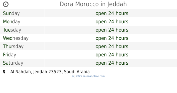
Dora Morocco
Jeddah
Cafe
read more
845 m
Lqma - لقمة
Jeddah
Cafe
read more
860 m
Costa Coffee
Al Batarji Branch, Jeddah
Cafe
read more
865 m
Juice&Dessert
Jeddah
Cafe
read more
872 m
Monsters icecream مونسترس ايسكريم
Hira Street, Jeddah
Cafe
read more
942 m
موكاتشينو
Jeddah
Cafe
read more
945 m
Mochachino JM-19
Hira Street, Jeddah
Cafe
read more
📑
all categories
Accounting
Administrative area level 1
Airport
Amusement park
Aquarium
Art gallery
Atm
Bakery
Bank
Bar
Beauty salon
Bicycle store
Book store
Bowling alley
Bus station
Cafe
Campground
Car dealer
Car rental
Car repair
Car wash
Casino
Cemetery
Church
City hall
Clothing store
Colloquial area
Convenience store
Country
Courthouse
Dentist
Department store
Doctor
Electrician
Electronics store
Embassy
Finance
Fire station
Florist
Food
Funeral home
Furniture store
Gas station
General contractor
Grocery or supermarket
Gym
Hair care
Hardware store
Health
Hindu Temple
Home goods store
Hospital
Insurance agency
Intersection
Jewelry store
Laundry
Lawyer
Library
Light rail station
Liquor store
Local government office
Locality
Locksmith
Lodging
Meal delivery
Meal takeaway
Mosque
Movie rental
Movie theater
Moving company
Museum
Natural feature
Neighborhood
Night club
Painter
Park
Parking
Pet store
Pharmacy
Physiotherapist
Place of worship
Plumber
Point of interest
Police
Political
Post office
Premise
Real estate agency
Restaurant
Roofing contractor
Route
Rv park, camping
School
Shoe store
Shopping mall
Spa
Stadium
Storage
Store
Sublocality
Subpremise
Subway station
Supermarket
Taxi stand
Train station
Transit station
Travel agency
University
Veterinary care
Zoo
sublocality level 1
↑