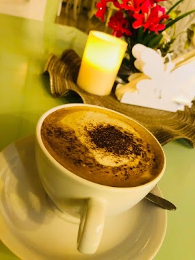
Cafe nearby Cafe Diwaniya Almstzlh
Coronavirus disease (COVID-19) Situation
confirmed cases
841469
deaths
9646
Saudi Arabia
Cafe nearby Cafe Diwaniya Almstzlh
Cafe Diwaniya Almstzlh
Dhahrat Laban, Riyadh 13786, Saudi Arabia
contacts phone
:
+966 50 988 1993
website:
www.facebook.com
Latitude:
24.6077855
, Longitude:
46.5217513
larger map & directions
read more
nearest Cafe
1.746 km
ديوانية ومقهى الكوب الفضي
Asir Street, Riyadh
Cafe
read more
1.761 km
ابو ناصر عبدالله
Riyadh
Cafe
read more
2.93 km
مقهى النكهات المنوعة
Tabuk Street, Riyadh
Cafe
read more
2.934 km
IZMIR KAHUECISI
Riyadh
Cafe
read more
2.961 km
Coffee taste of autumn
Tabuk, Riyadh
Cafe
read more
2.963 km
فريندز كافيه
3789 شارع عسير، الرياض
Cafe
read more
2.965 km
Friends Coffee
Asir Street, Riyadh
Cafe
read more
2.966 km
Friends Coffee
Assir Street, Riyadh
Cafe
read more
2.969 km
ريتشوني
Tabuk, Riyadh
Cafe
read more
2.982 km
ريتشوني
شارع تبوك، ظهرة لبن، الرياض
Cafe
read more
3.044 km
ناريز
شارع الوليد بن عبدالملك، حي طويق، الرياض
Cafe
read more
3.071 km
وفاء قلامر
Dhahrat Laban, Riyadh
Cafe
read more
3.141 km
Smoothie Cafe
7552 شارع ينبع، ظهرة لبن، الرياض
Cafe
read more
3.158 km
نسيم القهوة للسيدات
ينبع، ظهرة لبن،, Riyadh
Cafe
read more
3.16 km
مقهى لانا الصحراء
7445 حائل، ظهرة لبن، الرياض 13784
Cafe
read more
3.279 km
مقهى ناصر سلمان القحطاني للقهوة العربية
طريق خديجة بنت خويلد - حي طويق، الرياض
Cafe
read more
3.367 km
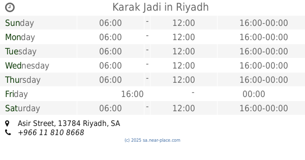
Karak Jadi
Assir Street, Riyadh
Cafe
read more
3.374 km
Karak Jadi
Asir Street, Riyadh
Cafe
read more
3.462 km
همسة مساء كافيه
4183 Asir Street, Riyadh
Cafe
read more
3.467 km
ديوانية كيف الاجداد
Riyadh
Cafe
read more
3.586 km
ديوانية نجمة الصبح
شارع الذهبي، حي طويق، الرياض
Cafe
read more
3.726 km
Diwaniya Al Faisaliah
3247 Taif, 8382, Riyadh
Cafe
read more
3.783 km
Cafe last Venjal
3929 ينبع، ظهرة لبن الرياض 13784 8013 Yanbu, Riyadh
Cafe
read more
3.815 km
انضمة الرذاذ والضباب
ظهرة لبن،, Riyadh
Cafe
read more
3.852 km
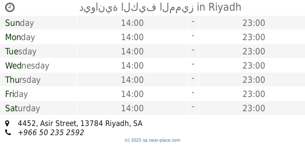
ديوانية الكيف المميز
4452 Asir Street, Riyadh
Cafe
read more
📑
all categories
Accounting
Administrative area level 1
Airport
Amusement park
Aquarium
Art gallery
Atm
Bakery
Bank
Bar
Beauty salon
Bicycle store
Book store
Bowling alley
Bus station
Cafe
Campground
Car dealer
Car rental
Car repair
Car wash
Casino
Cemetery
Church
City hall
Clothing store
Colloquial area
Convenience store
Country
Courthouse
Dentist
Department store
Doctor
Electrician
Electronics store
Embassy
Finance
Fire station
Florist
Food
Funeral home
Furniture store
Gas station
General contractor
Grocery or supermarket
Gym
Hair care
Hardware store
Health
Hindu Temple
Home goods store
Hospital
Insurance agency
Intersection
Jewelry store
Laundry
Lawyer
Library
Light rail station
Liquor store
Local government office
Locality
Locksmith
Lodging
Meal delivery
Meal takeaway
Mosque
Movie rental
Movie theater
Moving company
Museum
Natural feature
Neighborhood
Night club
Painter
Park
Parking
Pet store
Pharmacy
Physiotherapist
Place of worship
Plumber
Point of interest
Police
Political
Post office
Premise
Real estate agency
Restaurant
Roofing contractor
Route
Rv park, camping
School
Shoe store
Shopping mall
Spa
Stadium
Storage
Store
Sublocality
Subpremise
Subway station
Supermarket
Taxi stand
Train station
Transit station
Travel agency
University
Veterinary care
Zoo
sublocality level 1
↑