Cafe nearby Coffee Velvet
Coronavirus disease (COVID-19) Situation
confirmed cases
841469
deaths
9646
Saudi Arabia
Cafe nearby Coffee Velvet
Coffee Velvet
Prince Muhammad Ibn Saad Ibn Abdulaziz Road, 13532, Riyadh, SA Saudi Arabia
contacts phone
:
+966 50 433 3392
Latitude:
24.8219278
, Longitude:
46.5943037
larger map & directions
read more
nearest Cafe
13 m
Aron's Fresh
Riyadh
Cafe
read more
249 m
منتجع الشباب
Riyadh
Cafe
read more
417 m
3cofee
Riyadh
Cafe
read more
422 m
3 كوفي . مختصة طول الوقت
9525 الملقا الرياض 13525 5136
Cafe
read more
935 m
الرياض
رقم 319، الملقا،, Riyadh
Cafe
read more
963 m
كوفي الموعد
حبل قمبع, Riyadh
Cafe
read more
1.659 km
ارورا كافيه
Riyadh
Cafe
read more
1.664 km
AuroraCoffee
Riyadh
Cafe
read more
1.664 km
Aurora Coffee
Riyadh
Cafe
read more
1.692 km
Coffee bin Chadelya
6641 طريق الأمير محمد بن سعد بن عبدالعزيز، الملقا الرياض 13524 2626 Prince Muhammad Ibn Saad Ibn Abdulaziz Road, Riyadh
Cafe
read more
1.829 km
Istara 6
Unnamed Road, Riyadh
Cafe
read more
1.957 km
مقهى روزا مغربي
طريق الأمير محمد بن سعد بن عبدالعزيز،، الرياض
Cafe
read more
2.084 km
CAFFÈ VERGNANO 1882
King Fahad Road, Riyadh
Cafe
read more
2.165 km
أرابيكا
King Fahd Road, Riyadh
Cafe
read more
2.169 km
Arabica coffee
King Fahd Branch Road, Riyadh
Cafe
read more
2.182 km
kove HQ
Riyadh
Cafe
read more
2.194 km
بن كافيه
Riyadh
Cafe
read more
2.236 km
مقهى خالد الصيعري للقهوة العربية
طريق الملك فهد،، الرياض
Cafe
read more
2.254 km
تشوكليت هاڤانا
رقم 253،, Riyadh
Cafe
read more
2.292 km
ديوانية أوراق الكيف
الرياض
Cafe
read more
2.318 km
Shakey's (milkshake bar)
Riyadh
Cafe
read more
2.374 km
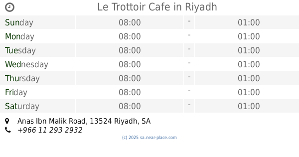
Le Trottoir Cafe
Anas Ibn Malik Road, Riyadh
Cafe
read more
2.375 km
المركاز لشاهي الجمري
Prince Turki Ibn Abdulaziz Al Awwal Road, Riyadh
Cafe
read more
2.378 km
ترو وتوار
Riyadh
Cafe
read more
2.38 km
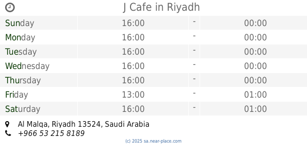
J Cafe
Riyadh
Cafe
read more
📑
all categories
Accounting
Administrative area level 1
Airport
Amusement park
Aquarium
Art gallery
Atm
Bakery
Bank
Bar
Beauty salon
Bicycle store
Book store
Bowling alley
Bus station
Cafe
Campground
Car dealer
Car rental
Car repair
Car wash
Casino
Cemetery
Church
City hall
Clothing store
Colloquial area
Convenience store
Country
Courthouse
Dentist
Department store
Doctor
Electrician
Electronics store
Embassy
Finance
Fire station
Florist
Food
Funeral home
Furniture store
Gas station
General contractor
Grocery or supermarket
Gym
Hair care
Hardware store
Health
Hindu Temple
Home goods store
Hospital
Insurance agency
Intersection
Jewelry store
Laundry
Lawyer
Library
Light rail station
Liquor store
Local government office
Locality
Locksmith
Lodging
Meal delivery
Meal takeaway
Mosque
Movie rental
Movie theater
Moving company
Museum
Natural feature
Neighborhood
Night club
Painter
Park
Parking
Pet store
Pharmacy
Physiotherapist
Place of worship
Plumber
Point of interest
Police
Political
Post office
Premise
Real estate agency
Restaurant
Roofing contractor
Route
Rv park, camping
School
Shoe store
Shopping mall
Spa
Stadium
Storage
Store
Sublocality
Subpremise
Subway station
Supermarket
Taxi stand
Train station
Transit station
Travel agency
University
Veterinary care
Zoo
sublocality level 1
↑