Cafe nearby Green Seeds Coffee
Saudi Arabia
Cafe nearby Green Seeds Coffee
Green Seeds Coffee
Al Firdaws, Saihat 32434, Saudi-Arabien
contacts phone
:
+966
Latitude:
26.4751412
, Longitude:
50.044388
larger map & directions
read more
nearest Cafe
144 m
55 Juice & Crepe
سيهات حي, Saihat
Cafe
read more
256 m
Dewanyat Abu Jana
Saihat
Cafe
read more
280 m
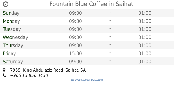
Fountain Blue Coffee
7955 King Abdulaziz Road, Saihat
Cafe
read more
333 m
ديوانية الحاج أكرم عطية
7379 2 ب، الزهور، سيهات 32437
Cafe
read more
396 m
Sakoon Sweets
7492 King Abdulaziz Road, Saihat
Cafe
read more
556 m
Cup Sweet
15th St، سيهات
Cafe
read more
570 m
Sip Milk
Saihat
Cafe
read more
583 m
Noura Cafè
4684 King Abdulaziz Road, Saihat
Cafe
read more
681 m
Five Degrees Cafe
15th Street, Saihat
Cafe
read more
685 m
5 Degrees Cafe مقهى الدرجة الخامسة
Saihat
Cafe
read more
778 m
Pie wrapped Restaurant Seihat
Saihat
Cafe
read more
839 m
Innovation Coffee
6352 King Abdulaziz Road, 3566, Saihat
Cafe
read more
917 m
المقهى الثقافي
4010 King Abdulaziz Road, Saihat
Cafe
read more
1.104 km
Lady Latte Cafe
15th Street, Building number 5127, Saihat
Cafe
read more
1.106 km
Lady Latte Cafe
15th St، سيهات
Cafe
read more
1.119 km
Lady Latte Cafe
15th Street, Saihat
Cafe
read more
1.16 km
Krispy Kreme
Khaleej Rd، سيهات
Cafe
read more
1.16 km
Krispy Kreme
Khaleej Road, Saihat
Cafe
read more
1.202 km
Derby Coffee
Saihat
Cafe
read more
1.205 km
كوفي شوب
7827 طريق الخليج، الكوثر، سيهات 32431
Cafe
read more
1.258 km
Platform11 Coffee
Saihat
Cafe
read more
1.286 km
Yellow
Dammam
Cafe
read more
1.328 km
هانغاوت كوفي شوب
طريق الخليج، حي المنتزة، سيهات
Cafe
read more
1.33 km
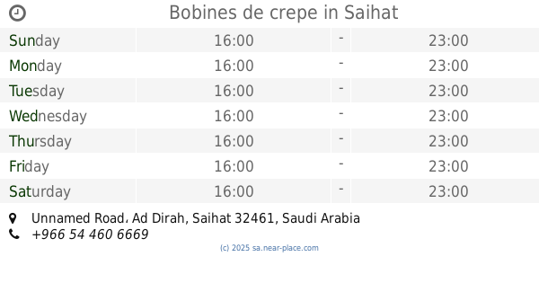
Bobines de crepe
Unnamed Road, Saihat
Cafe
read more
1.367 km
سمير أحمد آل قنبر
الديرة،, Saihat
Cafe
read more
📑
all categories
Accounting
Administrative area level 1
Airport
Amusement park
Aquarium
Art gallery
Atm
Bakery
Bank
Bar
Beauty salon
Bicycle store
Book store
Bowling alley
Bus station
Cafe
Campground
Car dealer
Car rental
Car repair
Car wash
Casino
Cemetery
Church
City hall
Clothing store
Colloquial area
Convenience store
Country
Courthouse
Dentist
Department store
Doctor
Electrician
Electronics store
Embassy
Finance
Fire station
Florist
Food
Funeral home
Furniture store
Gas station
General contractor
Grocery or supermarket
Gym
Hair care
Hardware store
Health
Hindu Temple
Home goods store
Hospital
Insurance agency
Intersection
Jewelry store
Laundry
Lawyer
Library
Light rail station
Liquor store
Local government office
Locality
Locksmith
Lodging
Meal delivery
Meal takeaway
Mosque
Movie rental
Movie theater
Moving company
Museum
Natural feature
Neighborhood
Night club
Painter
Park
Parking
Pet store
Pharmacy
Physiotherapist
Place of worship
Plumber
Point of interest
Police
Political
Post office
Premise
Real estate agency
Restaurant
Roofing contractor
Route
Rv park, camping
School
Shoe store
Shopping mall
Spa
Stadium
Storage
Store
Sublocality
Subpremise
Subway station
Supermarket
Taxi stand
Train station
Transit station
Travel agency
University
Veterinary care
Zoo
sublocality level 1
↑