Cafe nearby Joudy Cafe
Coronavirus disease (COVID-19) Situation
confirmed cases
841469
deaths
9646
Saudi Arabia
Cafe nearby Joudy Cafe
Joudy Cafe
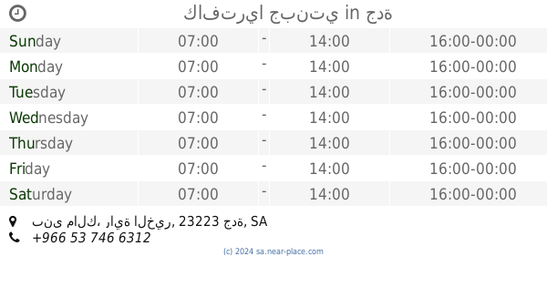
Al Urubah Street, 23335, Jeddah, SA Saudi Arabia
contacts phone
:
+966
Latitude:
21.534631
, Longitude:
39.202917
larger map & directions
read more
nearest Cafe
13 m
Judy Cafe
Al Urubah, Jeddah
Cafe
read more
188 m
بلاتينيا كافيه
4840 Falastin, حي مشرفة, Jeddah
Cafe
read more
194 m
Platina
4840 Falastin, حي مشرفة،, Jeddah
Cafe
read more
201 m
بلاتينيا كافيه
4840 Falastin، Jeddah
Cafe
read more
338 m
سناب كافيه
294, Jeddah
Cafe
read more
442 m
Asseerath Al Ameen
Al-Rabitah Al-Islamiyah, Jeddah
Cafe
read more
500 m
Cafe Najjar
6653 المكرونة، حي مشرفة، جدة 23335 4543 المكرونة حي مشرفة Jeddah Saudi Arabia 23335
Cafe
read more
571 m
Gourmet sweet
8229, Bani Malik District, Jeddah
Cafe
read more
628 m
قهوه بني مالك
Jeddah
Cafe
read more
662 m
عصير قصب العمده
Jeddah
Cafe
read more
751 m
مقهي الربيع
Unnamed Road, Jeddah
Cafe
read more
754 m
Reem Cafetria
4306 Al Mas, Jeddah
Cafe
read more
764 m
دهب كافية
Jeddah
Cafe
read more
786 m
الديوانية
Jeddah
Cafe
read more
809 m
Cafeteria Jawhara
2349, Bani Malik District, Jeddah
Cafe
read more
827 m
عصير قصب العمدة
Jeddah
Cafe
read more
894 m
قهوة الكتيابي بني مالك
Unnamed Road, Jeddah
Cafe
read more
896 m
كافتريا ليالينا
الأمير ماجد، بني مالك، جدة
Cafe
read more
912 m
كافتريا جبنتي
بني مالك، راية الخير، جدة
Cafe
read more
918 m
كفتريا جبنتي
2733, Bani Malik District, Jeddah
Cafe
read more
921 m
جبنتي بني مالك
2733، حي بنى مالك، جدة 23223
Cafe
read more
929 m
سانتوسکیفے پرنس ماجد جدہ
Unnamed Road, Jeddah
Cafe
read more
930 m
كافتريا جبنتي
حي بني مالك، جدة
Cafe
read more
930 m
كافتريا نهر النيل
حي بني مالك، جدة
Cafe
read more
944 m
سويت بسبوسة
At Tadamun Al Arabi, Jeddah
Cafe
read more
📑
all categories
Accounting
Administrative area level 1
Airport
Amusement park
Aquarium
Art gallery
Atm
Bakery
Bank
Bar
Beauty salon
Bicycle store
Book store
Bowling alley
Bus station
Cafe
Campground
Car dealer
Car rental
Car repair
Car wash
Casino
Cemetery
Church
City hall
Clothing store
Colloquial area
Convenience store
Country
Courthouse
Dentist
Department store
Doctor
Electrician
Electronics store
Embassy
Finance
Fire station
Florist
Food
Funeral home
Furniture store
Gas station
General contractor
Grocery or supermarket
Gym
Hair care
Hardware store
Health
Hindu Temple
Home goods store
Hospital
Insurance agency
Intersection
Jewelry store
Laundry
Lawyer
Library
Light rail station
Liquor store
Local government office
Locality
Locksmith
Lodging
Meal delivery
Meal takeaway
Mosque
Movie rental
Movie theater
Moving company
Museum
Natural feature
Neighborhood
Night club
Painter
Park
Parking
Pet store
Pharmacy
Physiotherapist
Place of worship
Plumber
Point of interest
Police
Political
Post office
Premise
Real estate agency
Restaurant
Roofing contractor
Route
Rv park, camping
School
Shoe store
Shopping mall
Spa
Stadium
Storage
Store
Sublocality
Subpremise
Subway station
Supermarket
Taxi stand
Train station
Transit station
Travel agency
University
Veterinary care
Zoo
sublocality level 1
↑