Cafe nearby منتجع الشمس
Saudi Arabia
Cafe nearby منتجع الشمس
منتجع الشمس
3071، Al Muntazah Al Gharbi, Hail 55424 3499, Saudi Arabia
contacts phone
:
+966 55 515 3994
Latitude:
27.5411815
, Longitude:
41.6687125
larger map & directions
read more
nearest Cafe
368 m
استراحة السيف بحايل
المنتزه الغربي، حائل
Cafe
read more
438 m
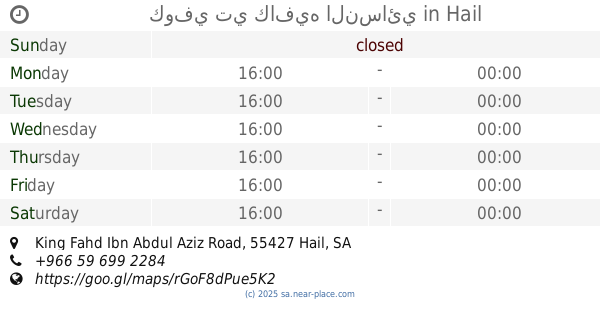
كوفي تي كافيه النسائي
King Fahd Ibn Abdul Aziz Road, Hail
Cafe
read more
497 m
شبة الحاره للقهوه العربية
المنتزه الغربي،
Cafe
read more
542 m
فيينا كوفي
المروج, Hail
Cafe
read more
562 m
VIENNA COFFEE
6907, Hail
Cafe
read more
920 m
بلياردو قولد كيو
3997 مكة مكرمة، العزيزية حائل 55424
Cafe
read more
1.343 km
بيان كافيه
2nd floor, 55461-4447, Block # 8114 King Fahad Road،, Hail
Cafe
read more
1.847 km
Crepegarden
3823 Jaddah, Hail
Cafe
read more
1.848 km
Crepe Garden
Hail
Cafe
read more
1.905 km
TEGEINSEE CAFE كوفي شوب للنساء فقط
3823-3847 Jaddah, Hail
Cafe
read more
1.907 km
سلة الكيف
Hail
Cafe
read more
1.938 km
أوبرا كافية
3909 Jaddah, 3887-, Hail
Cafe
read more
1.973 km
Coffee Originality
Hail
Cafe
read more
2.106 km
ستيج العرب كافيه
الوسيطاء،
Cafe
read more
2.127 km
Authenticity coffee - Hassoun Mall
Hail
Cafe
read more
2.263 km
Arabica Time
جدة Jaddah, Hail
Cafe
read more
2.424 km
كوفي MP3
صلاح الدين الغربي،, Hail
Cafe
read more
2.432 km
قاعة مسك للأحتفالات
Hail
Cafe
read more
2.456 km
استراحة العزيزية
5284 ظافر الكاظم, Hail
Cafe
read more
2.481 km
تعاليل الديوان
الوسيطاء،
Cafe
read more
2.487 km
ماستر كوفي 2
Umm Al Muminin Aishah, Hail
Cafe
read more
2.497 km
روائع و فن الحايليات
7022 Al Amir Saad Ibn Fahd, Hail
Cafe
read more
2.506 km
Ewan coffee shop coffee
3926 طريق عقدة، الوسيطاء حائل 55424 7394 Uqdah Road, Hail
Cafe
read more
2.508 km
Caffein Time
3811 Uqdah Road, Hail
Cafe
read more
2.524 km
اولد كوفي
Uqdah Road, Hail
Cafe
read more
📑
all categories
Accounting
Administrative area level 1
Airport
Amusement park
Aquarium
Art gallery
Atm
Bakery
Bank
Bar
Beauty salon
Bicycle store
Book store
Bowling alley
Bus station
Cafe
Campground
Car dealer
Car rental
Car repair
Car wash
Casino
Cemetery
Church
City hall
Clothing store
Colloquial area
Convenience store
Country
Courthouse
Dentist
Department store
Doctor
Electrician
Electronics store
Embassy
Finance
Fire station
Florist
Food
Funeral home
Furniture store
Gas station
General contractor
Grocery or supermarket
Gym
Hair care
Hardware store
Health
Hindu Temple
Home goods store
Hospital
Insurance agency
Intersection
Jewelry store
Laundry
Lawyer
Library
Light rail station
Liquor store
Local government office
Locality
Locksmith
Lodging
Meal delivery
Meal takeaway
Mosque
Movie rental
Movie theater
Moving company
Museum
Natural feature
Neighborhood
Night club
Painter
Park
Parking
Pet store
Pharmacy
Physiotherapist
Place of worship
Plumber
Point of interest
Police
Political
Post office
Premise
Real estate agency
Restaurant
Roofing contractor
Route
Rv park, camping
School
Shoe store
Shopping mall
Spa
Stadium
Storage
Store
Sublocality
Subpremise
Subway station
Supermarket
Taxi stand
Train station
Transit station
Travel agency
University
Veterinary care
Zoo
sublocality level 1
↑