Cafe nearby Motaka Cafe︱مُتكأ
Coronavirus disease (COVID-19) Situation
confirmed cases
841469
deaths
9646
Saudi Arabia
Cafe nearby Motaka Cafe︱مُتكأ
Motaka Cafe︱مُتكأ
Prince Sultan Road, 23525, Jeddah, SA Saudi Arabia
contacts phone
:
+966 12 275 0610
website:
motaka-cafe-cafe.business.site
Latitude:
21.6096605
, Longitude:
39.1417353
larger map & directions
read more
nearest Cafe
308 m
Yogorino
Al Amir Sultan, Jeddah
Cafe
read more
344 m
Sofly Shehar
4107 حراء, حي الزهراء،, Jeddah
Cafe
read more
350 m
Barncafe بارن كافيه
HERAH STREET BEFORE AMIR SULTAN STREET BESIDE ALAM ALASAER, Jeddah, AL-ZAHRA'A, حي الزهراء - شارع حراء, فرع حراء 2, Jeddah
Cafe
read more
503 m
موكاتشينو
Jeddah
Cafe
read more
503 m
Mochachino JM-19
Hira Street, Jeddah
Cafe
read more
710 m
Dunkin Donuts
3740 Hira Street, Jeddah
Cafe
read more
882 m
بارتي كافي
Prince Sultan Road, Jeddah
Cafe
read more
905 m
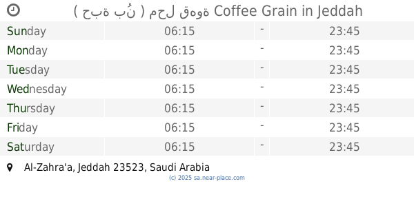
( حبة بُن ) محل قهوة Coffee Grain
Jeddah
Cafe
read more
908 m
Beans coffee
Jeddah
Cafe
read more
957 m
JAZLI
2500 Abu Wahib Al Jashmi, An Naim District,, Jeddah
Cafe
read more
960 m
Starbucks Coffee
2171 لامير سلطان, جدة
Cafe
read more
974 m
قلنار كافية Gulnar Cafe
Jeddah
Cafe
read more
996 m
House of Donuts
Jeddah
Cafe
read more
1.031 km
عمارة جده حي الزهراء
Jeddah
Cafe
read more
1.076 km
Coffee Corner
2721 النعيم, حي النعيم، 8839, Jeddah
Cafe
read more
1.076 km
Coffee Corner
2721 شارع النعيم, حي النعيم، جدة
Cafe
read more
1.078 km
Kankah
احمد بن عسيب، حي النعيم، جدة
Cafe
read more
1.078 km
Kankah
8574 احمد بن عسيب، حي النعيم جدة 23526 3186 احمد بن عسيب, Jeddah
Cafe
read more
1.085 km
Bonnon Coffee
Jeddah
Cafe
read more
1.087 km
لاترافيات LATRAVIATA
Jeddah
Cafe
read more
1.112 km
تورشيللو كافيه
An Naeem Street, Jeddah
Cafe
read more
1.141 km
كوفي شوب البتول
Jeddah
Cafe
read more
1.171 km
لذة القهوة
4550 Al Batarji, حي الزهراء, Jeddah
Cafe
read more
1.201 km
DonutMagic
3567 Khalil Bik Al Ajjan, AZ Zahra District,, Jeddah
Cafe
read more
1.205 km
Suitable Time Cafe
6924 الامير سلطان, AZ Zahra District,, Jeddah
Cafe
read more
📑
all categories
Accounting
Administrative area level 1
Airport
Amusement park
Aquarium
Art gallery
Atm
Bakery
Bank
Bar
Beauty salon
Bicycle store
Book store
Bowling alley
Bus station
Cafe
Campground
Car dealer
Car rental
Car repair
Car wash
Casino
Cemetery
Church
City hall
Clothing store
Colloquial area
Convenience store
Country
Courthouse
Dentist
Department store
Doctor
Electrician
Electronics store
Embassy
Finance
Fire station
Florist
Food
Funeral home
Furniture store
Gas station
General contractor
Grocery or supermarket
Gym
Hair care
Hardware store
Health
Hindu Temple
Home goods store
Hospital
Insurance agency
Intersection
Jewelry store
Laundry
Lawyer
Library
Light rail station
Liquor store
Local government office
Locality
Locksmith
Lodging
Meal delivery
Meal takeaway
Mosque
Movie rental
Movie theater
Moving company
Museum
Natural feature
Neighborhood
Night club
Painter
Park
Parking
Pet store
Pharmacy
Physiotherapist
Place of worship
Plumber
Point of interest
Police
Political
Post office
Premise
Real estate agency
Restaurant
Roofing contractor
Route
Rv park, camping
School
Shoe store
Shopping mall
Spa
Stadium
Storage
Store
Sublocality
Subpremise
Subway station
Supermarket
Taxi stand
Train station
Transit station
Travel agency
University
Veterinary care
Zoo
sublocality level 1
↑