Cafe nearby مقهى شعبي تراثي
Coronavirus disease (COVID-19) Situation
confirmed cases
841469
deaths
9646
Saudi Arabia
Cafe nearby مقهى شعبي تراثي
مقهى شعبي تراثي
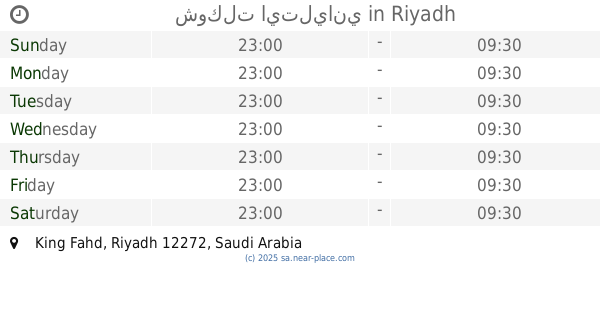
Riyadh Saudi Arabia
contacts phone
:
+966
Latitude:
24.7429674
, Longitude:
46.6696641
read more
nearest Cafe
679 m
ستاربوكس
7639 طريق الفرعي، الملك فهد 3168 جاليري الدور الارضي، الرياض, Riyadh
Cafe
read more
732 m
مسار نجد
2957 Al Imam Saud Ibn Abdul Aziz Branch Road, Riyadh
Cafe
read more
745 m
كالدو حي الملك فهد
الملك فهد،, Riyadh
Cafe
read more
757 m
Raae Alkaif Roasters
Riyadh
Cafe
read more
792 m
Java Time
Ibn An Nassir, Riyadh
Cafe
read more
875 m
مقهى مذاقات مبتكرة
طريق الإمام سعود - حي المروج، الرياض
Cafe
read more
884 m
Cafe innovative flavors
Prince Jalawi Bin Turki Bin Abdulaziz Street, Riyadh
Cafe
read more
892 m
Cafe innovative flavors
Prince Jalawi Ibn Turki Ibn Abdul Aziz، الرياض
Cafe
read more
897 m
Cafe Savour
Prince Jalawi Bin Turki Bin Abdulaziz St Prince Jalawi Bin Turki Bin Abdulaziz Street, Riyadh
Cafe
read more
907 m
Bubbles Tree - شجرة الفقاعات
Mohamed Hamed al-Feki, Riyadh
Cafe
read more
925 m
The Shaky
Riyadh
Cafe
read more
929 m
عطار النجراني
Olaya Street, Riyadh
Cafe
read more
933 m
White Garden
Riyadh
Cafe
read more
933 m
Coffe Madam
7238 Al Ulaya, Riyadh
Cafe
read more
952 m
kareem cafe
Riyadh
Cafe
read more
955 m
مقهى واحة الدار
Almughirah Ibn Shubah, Al Muruj، الرياض
Cafe
read more
960 m
Lamode Hayat mall
7544 King Abdul Aziz Rd, King Fahd, Riyadh 12272 4170 King Abdul Aziz Road, Riyadh
Cafe
read more
976 m
Gelatalia Cafe
7418 Mohamed Hamed al-Feki, Riyadh
Cafe
read more
976 m
Maya Cafe
Riyadh
Cafe
read more
1.006 km
شوكلت ايتلياني
Riyadh
Cafe
read more
1.016 km
Dippinggo Hayat Mall
Riyadh
Cafe
read more
1.02 km
New Zealand Natural
Riyadh
Cafe
read more
1.023 km
STARBUCKS COFFEE
Rodh Al Jawa, Hayat Mall, Riyadh
Cafe
read more
1.026 km
dipndip
3998 AlWalid Ibn Sulaiman, Riyadh
Cafe
read more
1.031 km
تشيمني كيك
7544 King Abdul Aziz Road, Riyadh
Cafe
read more
📑
all categories
Accounting
Administrative area level 1
Airport
Amusement park
Aquarium
Art gallery
Atm
Bakery
Bank
Bar
Beauty salon
Bicycle store
Book store
Bowling alley
Bus station
Cafe
Campground
Car dealer
Car rental
Car repair
Car wash
Casino
Cemetery
Church
City hall
Clothing store
Colloquial area
Convenience store
Country
Courthouse
Dentist
Department store
Doctor
Electrician
Electronics store
Embassy
Finance
Fire station
Florist
Food
Funeral home
Furniture store
Gas station
General contractor
Grocery or supermarket
Gym
Hair care
Hardware store
Health
Hindu Temple
Home goods store
Hospital
Insurance agency
Intersection
Jewelry store
Laundry
Lawyer
Library
Light rail station
Liquor store
Local government office
Locality
Locksmith
Lodging
Meal delivery
Meal takeaway
Mosque
Movie rental
Movie theater
Moving company
Museum
Natural feature
Neighborhood
Night club
Painter
Park
Parking
Pet store
Pharmacy
Physiotherapist
Place of worship
Plumber
Point of interest
Police
Political
Post office
Premise
Real estate agency
Restaurant
Roofing contractor
Route
Rv park, camping
School
Shoe store
Shopping mall
Spa
Stadium
Storage
Store
Sublocality
Subpremise
Subway station
Supermarket
Taxi stand
Train station
Transit station
Travel agency
University
Veterinary care
Zoo
sublocality level 1
↑