Cafe nearby قهوة الكيان
Saudi Arabia
Cafe nearby قهوة الكيان
قهوة الكيان
Buraydah 52582, Saudi Arabia
contacts phone
:
+966
Latitude:
26.39661
, Longitude:
43.8705375
larger map & directions
read more
nearest Cafe
1.817 km
new shope
Buraydah
Cafe
read more
3.29 km
ديوانية ابن سويلم
Unnamed Road, Buraydah
Cafe
read more
3.464 km
ابوناصر
الغروب, Buraydah
Cafe
read more
3.661 km
Arabica star
2879 King Abdulaziz Rd Ash Shiqah Buraydah 52566 8410 King Abdulaziz Road, Buraydah
Cafe
read more
4.11 km
استراحة الخزامى
7776، البشر، بريدة 52377
Cafe
read more
4.126 km
Lantana Truck لانتانا
Unnamed Road, Buraydah
Cafe
read more
4.245 km
Levanti Cafe
شارع البخاري, Buraydah
Cafe
read more
4.327 km
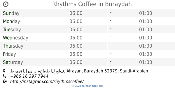
Rhythms Coffee
طريق الريان مخطط الرواف, Buraydah
Cafe
read more
4.347 km
كانتو Canto
شارع البخاري،، بريدة
Cafe
read more
4.352 km
AURELIA Speclalty Coffee
Buraydah
Cafe
read more
4.353 km
AURELIA SPECIALITY COOFFEE
Buraydah
Cafe
read more
4.358 km
Canto Specialty Coffee
شارع البخاري, Buraydah
Cafe
read more
4.385 km
Gloria Jeans | جلوريا جينز
Buraydah
Cafe
read more
4.555 km
Le Churro Station
شارع البخاري, Buraydah
Cafe
read more
4.624 km
Cafe Baghdadi Arabic coffee
الشقة، العليا، بريدة
Cafe
read more
4.641 km
كيك وكافيه لوز
شارع البخاري, Buraydah
Cafe
read more
4.665 km
Gloria Jean's Coffees
شارع البخاري, Buraydah
Cafe
read more
4.671 km
غلوريا جينز كوفيز
شارع البخاري ، حي الريان، بريدة
Cafe
read more
4.695 km
دلة الاجداد
4833, Buraydah
Cafe
read more
4.742 km
رشفة روعة القهوة
4770, 7170, Buraydah
Cafe
read more
4.743 km
Rshfah coffee
4770 الريان، بريدة 52379
Cafe
read more
4.765 km
modi cafe
Buraydah
Cafe
read more
4.776 km
Blue Gold Coffee
Buraydah
Cafe
read more
4.829 km
Caffe bene
Al Bukhari Street, Ar Rayyan، بريدة
Cafe
read more
4.925 km
ماما روتي كافيه
Buraydah
Cafe
read more
📑
all categories
Accounting
Administrative area level 1
Airport
Amusement park
Aquarium
Art gallery
Atm
Bakery
Bank
Bar
Beauty salon
Bicycle store
Book store
Bowling alley
Bus station
Cafe
Campground
Car dealer
Car rental
Car repair
Car wash
Casino
Cemetery
Church
City hall
Clothing store
Colloquial area
Convenience store
Country
Courthouse
Dentist
Department store
Doctor
Electrician
Electronics store
Embassy
Finance
Fire station
Florist
Food
Funeral home
Furniture store
Gas station
General contractor
Grocery or supermarket
Gym
Hair care
Hardware store
Health
Hindu Temple
Home goods store
Hospital
Insurance agency
Intersection
Jewelry store
Laundry
Lawyer
Library
Light rail station
Liquor store
Local government office
Locality
Locksmith
Lodging
Meal delivery
Meal takeaway
Mosque
Movie rental
Movie theater
Moving company
Museum
Natural feature
Neighborhood
Night club
Painter
Park
Parking
Pet store
Pharmacy
Physiotherapist
Place of worship
Plumber
Point of interest
Police
Political
Post office
Premise
Real estate agency
Restaurant
Roofing contractor
Route
Rv park, camping
School
Shoe store
Shopping mall
Spa
Stadium
Storage
Store
Sublocality
Subpremise
Subway station
Supermarket
Taxi stand
Train station
Transit station
Travel agency
University
Veterinary care
Zoo
sublocality level 1
↑