Cafe nearby Sayyartek Cafe
Saudi Arabia
Cafe nearby Sayyartek Cafe
Sayyartek Cafe
Al-Nuzhah, Jeddah 23536, Saudi Arabia
contacts phone
:
+966
Latitude:
21.6183513
, Longitude:
39.1780692
larger map & directions
read more
nearest Cafe
181 m
كافيه العندليب
شارع حراء،, Jeddah
Cafe
read more
185 m
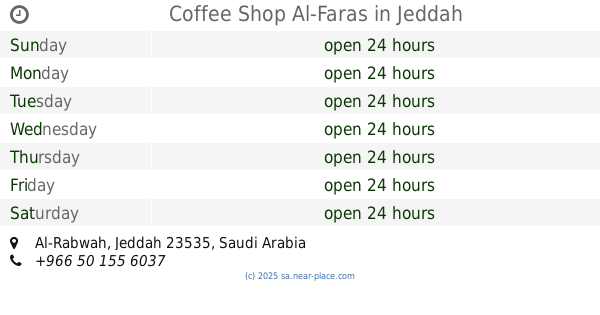
Coffee Shop Al-Faras
Jeddah
Cafe
read more
244 m
Alkaif Almaghrabi الكيف المغربي
النزهة، جدة
Cafe
read more
300 m
Mezyan Coffee
Hira Street, Jeddah
Cafe
read more
330 m
ديوانية صدى الملاعب
الربوة،, Jeddah
Cafe
read more
341 m
ديوانية صدى الملاعب
حي الربوة، جدة
Cafe
read more
433 m
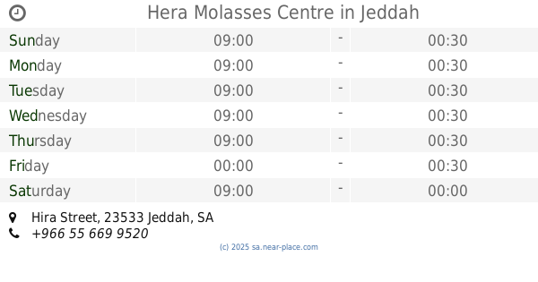
Hera Molasses Centre
Hira Street, Jeddah
Cafe
read more
542 m
مقهى وكافيه الأصدقاء
حي الربوة، جدة
Cafe
read more
543 m
كافيه الأصدقاء
Jeddah
Cafe
read more
579 m
بيت الشيخ بشر بن ثابت
4775-4869 محمد عبدالحي، الربوة،, Jeddah
Cafe
read more
632 m
Qariat Al-Finjal Cafe مقهى قارئة الفنجال
4082 Hira Street, Jeddah
Cafe
read more
675 m
ديوانية مهند السليمان
Jeddah
Cafe
read more
679 m
ديوانية مهند
6582 غضا ابو فرانس، حي النزهة جدة 23534
Cafe
read more
705 m
آذار كافيه
8017 الطفيل بن زيد، حي الربوة جدة 23535
Cafe
read more
707 m
آذار كافيه 🎮
Yahya Al Mualimi, Jeddah
Cafe
read more
714 m
Bonnon Coffee
Hira Street, Jeddah
Cafe
read more
809 m
قهوة الأكابر
حي الربوة، جدة
Cafe
read more
820 m
كوفي جمعان
شارع حراء،, Jeddah
Cafe
read more
825 m
Akaber Cafe
Yahya Al Mualimi, قهوة الأكابر Akaber Cafe, Jeddah
Cafe
read more
835 m
معازيم
شارع حراء، حي الربوة، جدة
Cafe
read more
855 m
معازيم كافيه
Jeddah
Cafe
read more
895 m
معسلات جدة
Jeddah
Cafe
read more
898 m
Carየእኔ
3918 Sultan Ibn Salman, An Nuzhah District, Jeddah 23534 6788 Sultan Ibn Salman, Jeddah
Cafe
read more
995 m
كافيه الهرم
المروة،, Jeddah
Cafe
read more
1.145 km
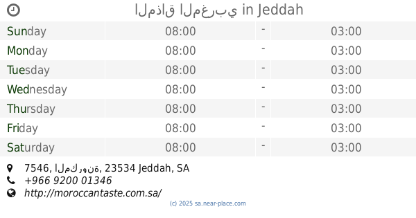
المذاق المغربي
7546 المكرونة, حي النزهة 4255, Jeddah
Cafe
read more
📑
all categories
Accounting
Administrative area level 1
Airport
Amusement park
Aquarium
Art gallery
Atm
Bakery
Bank
Bar
Beauty salon
Bicycle store
Book store
Bowling alley
Bus station
Cafe
Campground
Car dealer
Car rental
Car repair
Car wash
Casino
Cemetery
Church
City hall
Clothing store
Colloquial area
Convenience store
Country
Courthouse
Dentist
Department store
Doctor
Electrician
Electronics store
Embassy
Finance
Fire station
Florist
Food
Funeral home
Furniture store
Gas station
General contractor
Grocery or supermarket
Gym
Hair care
Hardware store
Health
Hindu Temple
Home goods store
Hospital
Insurance agency
Intersection
Jewelry store
Laundry
Lawyer
Library
Light rail station
Liquor store
Local government office
Locality
Locksmith
Lodging
Meal delivery
Meal takeaway
Mosque
Movie rental
Movie theater
Moving company
Museum
Natural feature
Neighborhood
Night club
Painter
Park
Parking
Pet store
Pharmacy
Physiotherapist
Place of worship
Plumber
Point of interest
Police
Political
Post office
Premise
Real estate agency
Restaurant
Roofing contractor
Route
Rv park, camping
School
Shoe store
Shopping mall
Spa
Stadium
Storage
Store
Sublocality
Subpremise
Subway station
Supermarket
Taxi stand
Train station
Transit station
Travel agency
University
Veterinary care
Zoo
sublocality level 1
↑