Cafe nearby Taste for fast food
Coronavirus disease (COVID-19) Situation
confirmed cases
841469
deaths
9646
Saudi Arabia
Cafe nearby Taste for fast food
Taste for fast food
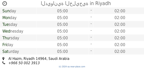
Okaz, Riyadh 14723, Saudi Arabia
contacts phone
:
+966 53 616 1635
Latitude:
24.5243051
, Longitude:
46.661378
larger map & directions
read more
nearest Cafe
23 m
Taste for fast food
شارع الطياش، عكاظ، الرياض
Cafe
read more
277 m
ايس كريم الراجحي
Riyadh
Cafe
read more
370 m
الراجحي للايسكريم
الرصافة, حي عكاظ- شارع, Riyadh
Cafe
read more
913 m
جوهرة كافيه
Al Tiyash, Riyadh
Cafe
read more
996 m
ديوانية عكاظ للقهوة العربية
Riyadh
Cafe
read more
1.004 km
coffee tale
Al Hamadhani, Riyadh
Cafe
read more
1.369 km
Al Magreb Cafè
7464 Dirab Branch Road, Riyadh
Cafe
read more
1.455 km
ستاربكس
7355 طريق ديراب الفرعي، المروة، الرياض 14722
Cafe
read more
1.456 km
Starbucks
Almarwah, Riyadh
Cafe
read more
1.519 km
كاسه فرش
Dirab Branch Road, Riyadh
Cafe
read more
1.834 km
مقهى للقهوه العربيه الدله المثلوثه
الرياض
Cafe
read more
1.844 km
مقهى الحزم للقهوه العربيه
الرياض
Cafe
read more
1.846 km
Cafe function Almtluth
Al mathari, 6490 المطري، الحزم، الرياض 14964 3730, Riyadh
Cafe
read more
1.886 km
10 SPORT CAFE
6677 Al mathari, Al Hazm, Riyadh 14964 3873 Al mathari, Riyadh
Cafe
read more
1.909 km
Cafe Slav
حمزة ابن عبد المطلب، الرياض
Cafe
read more
1.929 km
مقهى بوست كوفي
6655 المطري،, Riyadh
Cafe
read more
2.293 km
لقماتايز
Al mathari, Riyadh
Cafe
read more
2.294 km
Light juice
4079 Al Madiq, Riyadh
Cafe
read more
2.343 km
عبدالمسحن بن مقيت الشبوي
7416-7370 Ibn Abud, Riyadh
Cafe
read more
2.347 km
استراحة الخراعين
Ali Ibn An Naqib, Riyadh
Cafe
read more
2.406 km
استراحة ريوف
Unnamed Road, Riyadh
Cafe
read more
2.424 km
Diwaniya Alhdadin
3292, Riyadh
Cafe
read more
2.424 km
GM Cafe
7047 Hamzah Ibn Abdul Mutalib, Riyadh
Cafe
read more
2.508 km
Java Time
8409 2854 طريق ديراب الفرعي، المروة، الرياض
Cafe
read more
2.57 km
الديوانية الخليجية
Riyadh
Cafe
read more
📑
all categories
Accounting
Administrative area level 1
Airport
Amusement park
Aquarium
Art gallery
Atm
Bakery
Bank
Bar
Beauty salon
Bicycle store
Book store
Bowling alley
Bus station
Cafe
Campground
Car dealer
Car rental
Car repair
Car wash
Casino
Cemetery
Church
City hall
Clothing store
Colloquial area
Convenience store
Country
Courthouse
Dentist
Department store
Doctor
Electrician
Electronics store
Embassy
Finance
Fire station
Florist
Food
Funeral home
Furniture store
Gas station
General contractor
Grocery or supermarket
Gym
Hair care
Hardware store
Health
Hindu Temple
Home goods store
Hospital
Insurance agency
Intersection
Jewelry store
Laundry
Lawyer
Library
Light rail station
Liquor store
Local government office
Locality
Locksmith
Lodging
Meal delivery
Meal takeaway
Mosque
Movie rental
Movie theater
Moving company
Museum
Natural feature
Neighborhood
Night club
Painter
Park
Parking
Pet store
Pharmacy
Physiotherapist
Place of worship
Plumber
Point of interest
Police
Political
Post office
Premise
Real estate agency
Restaurant
Roofing contractor
Route
Rv park, camping
School
Shoe store
Shopping mall
Spa
Stadium
Storage
Store
Sublocality
Subpremise
Subway station
Supermarket
Taxi stand
Train station
Transit station
Travel agency
University
Veterinary care
Zoo
sublocality level 1
↑