Cafe nearby Verocci Cafe ڨيروتشي كافيه
Saudi Arabia
Cafe nearby Verocci Cafe ڨيروتشي كافيه
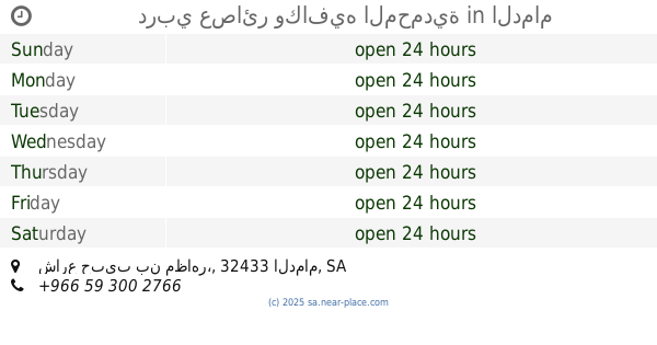
Verocci Cafe ڨيروتشي كافيه
Al Muhammadiyah, Dammam 32433, Saudi Arabia
contacts phone
:
+966
Latitude:
26.4541039
, Longitude:
50.0621596
larger map & directions
read more
nearest Cafe
80 m
la casa de coffee
العزيزية،, Dammam
Cafe
read more
159 m
مركز أوراق الشاي الأخضر
شارع الأمير نايف، حي المحمدية، الدمام
Cafe
read more
718 m
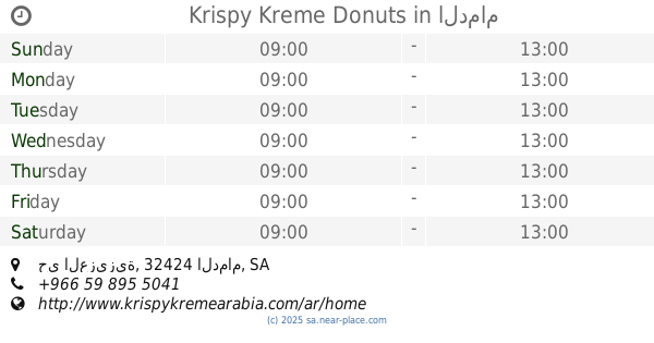
Krispy Kreme Donuts
مجمع دارين مول، حي العزيزية، الدمام
Cafe
read more
718 m
Krispy Kreme Donuts
مجمع دارين مول, حي العزيزية, Dammam
Cafe
read more
718 m
كرسبي كريم دوناتس
مجمع دارين مول، حي العزيزية، الدمام
Cafe
read more
793 m
دربي عصائر وكافيه المحمدية
شارع حبيب بن مظاهر،، الدمام
Cafe
read more
813 m
عصائر دربي
Dammam
Cafe
read more
829 m
قهوة ليوان
دارين مول، حي الصفا، بوابة 2، الدمام
Cafe
read more
871 m
سينابون
دارين مول، حي الصفا، الدمام
Cafe
read more
879 m
Chai Makkani
7705 Umar Ibn Abdul Aziz, Al Muhammadiyah, Dammam 32432 4356
Cafe
read more
912 m
بابا روتي
مجمع الدارين مول، طريق الخليج ، حي العزيزية، الدمام
Cafe
read more
914 m
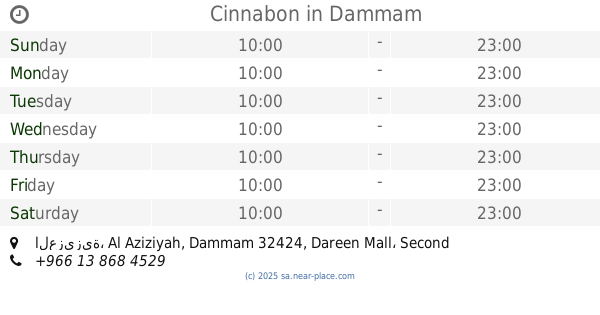
Cinnabon
مجمع الدارين مول، طريق الخليج، حي العزيزية، الدمام
Cafe
read more
914 m
Cinnabon
العزيزية، Al Aziziyah, Dammam 32424, Dareen Mall، Second Floor،, Dammam
Cafe
read more
940 m
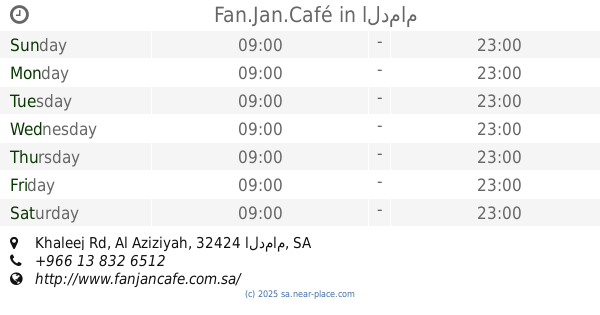
Fan.Jan.Café
دارين مول، Khaleej Rd, Al Aziziyah، الدمام
Cafe
read more
965 m
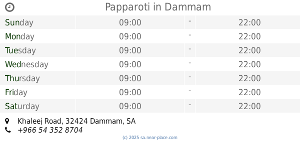
Papparoti
Khaleej Road, Dammam
Cafe
read more
977 m
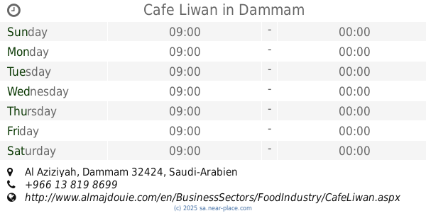
Cafe Liwan
Dammam
Cafe
read more
986 m
Coffee Valley
Prince Nayef Bin Abdulaziz Road, Dammam
Cafe
read more
1.03 km
ديوانية بن عاقول
Omar Ibn Abdulaziz Street, Saihat
Cafe
read more
1.03 km
Sugar Sprinkles
Centro Al-Khaleej, Dammam
Cafe
read more
1.032 km
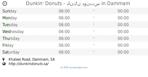
Dunkin' Donuts - دانكن دونتس
Khaleej Road, Dammam
Cafe
read more
1.045 km
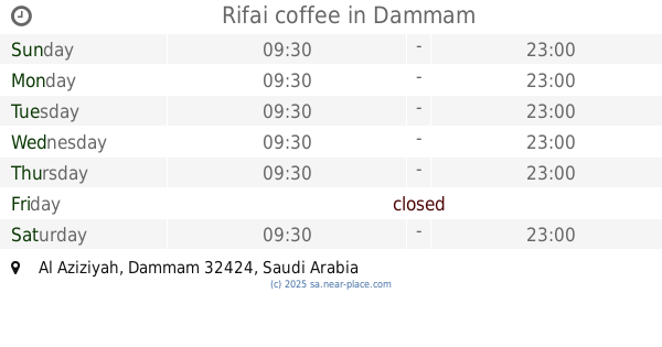
Rifai coffee
Dammam
Cafe
read more
1.096 km
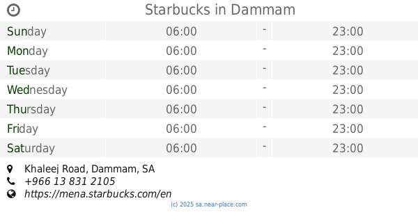
Starbucks
Khaleej Road, Dammam
Cafe
read more
1.108 km
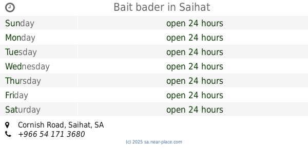
Bait bader
Cornish Road, Saihat
Cafe
read more
1.253 km
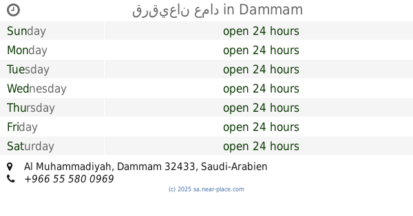
قرقيعان عماد
Dammam
Cafe
read more
1.397 km
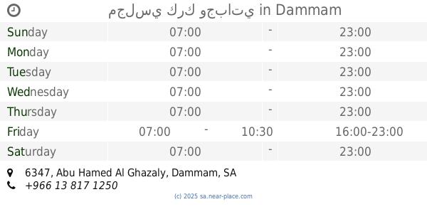
مجلسي كرك وجباتي
6347 Abu Hamed Al Ghazaly, Dammam
Cafe
read more
📑
all categories
Accounting
Administrative area level 1
Airport
Amusement park
Aquarium
Art gallery
Atm
Bakery
Bank
Bar
Beauty salon
Bicycle store
Book store
Bowling alley
Bus station
Cafe
Campground
Car dealer
Car rental
Car repair
Car wash
Casino
Cemetery
Church
City hall
Clothing store
Colloquial area
Convenience store
Country
Courthouse
Dentist
Department store
Doctor
Electrician
Electronics store
Embassy
Finance
Fire station
Florist
Food
Funeral home
Furniture store
Gas station
General contractor
Grocery or supermarket
Gym
Hair care
Hardware store
Health
Hindu Temple
Home goods store
Hospital
Insurance agency
Intersection
Jewelry store
Laundry
Lawyer
Library
Light rail station
Liquor store
Local government office
Locality
Locksmith
Lodging
Meal delivery
Meal takeaway
Mosque
Movie rental
Movie theater
Moving company
Museum
Natural feature
Neighborhood
Night club
Painter
Park
Parking
Pet store
Pharmacy
Physiotherapist
Place of worship
Plumber
Point of interest
Police
Political
Post office
Premise
Real estate agency
Restaurant
Roofing contractor
Route
Rv park, camping
School
Shoe store
Shopping mall
Spa
Stadium
Storage
Store
Sublocality
Subpremise
Subway station
Supermarket
Taxi stand
Train station
Transit station
Travel agency
University
Veterinary care
Zoo
sublocality level 1
↑