Cafe nearby W
Saudi Arabia
Cafe nearby W
W
Al-Khalidiyah, Jeddah 23421, Saudi-Arabien
contacts phone
:
+966
Latitude:
21.5488984
, Longitude:
39.1356904
larger map & directions
read more
nearest Cafe
32 m
زوارة الحريم
Jeddah
Cafe
read more
181 m
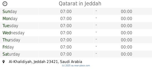
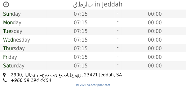
Qatarat
Jeddah
Cafe
read more
182 m
قطرات
2900 الامير محمد بن عبدالعزيز, Al Khalidiyah District, Jeddah
Cafe
read more
232 m
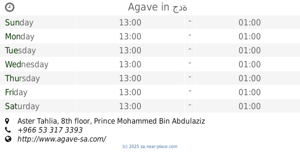
Agave
Aster Tahlia, 8th floor, Prince Mohammed Bin Abdulaziz Street, Al Khalidiyah، جدة
Cafe
read more
338 m
Arabica Coffee House
Prince Mohammed Bin Abdulaziz Street, Jeddah
Cafe
read more
377 m
Maya La Chocolaterie
Jeddah
Cafe
read more
608 m
MOHAMMED IBRAHIM GHAZAL
Tahlia Street, Jeddah
Cafe
read more
608 m
MOHAMMED IBRAHIM GHAZAL
tahlia street، جدة
Cafe
read more
743 m
VIEW LOUNGE
شارع التحلية، جدة
Cafe
read more
745 m
بيرتز
Jeddah
Cafe
read more
755 m
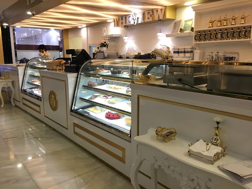
The View Lounge ذى ڤيو لاونج
Prince Mohammed Bin Abdulaziz Street, Jeddah
Cafe
read more
758 m
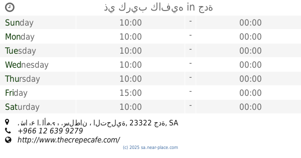
ذي كريب كافيه
مركز روشانة التحلية، شارع الأمير سلطان ، التحلية، جدة
Cafe
read more
761 m
رد مانجو
Roshana Mall, Prince Mohammed Bin Abdulaziz Street, Jeddah
Cafe
read more
763 m
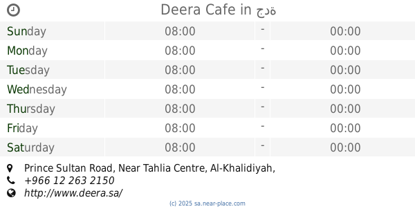
Deera Cafe
Prince Sultan Road, Near Tahlia Centre, Al-Khalidiyah, Jeddah
Cafe
read more
763 m
Deera Cafe
Prince Sultan Road, Near Tahlia Centre, Al-Khalidiyah، جدة
Cafe
read more
767 m
Bert's
3403 الامير محمد بن عبدالعزيز, Al Andalus District,, Jeddah
Cafe
read more
768 m
The Crepe Cafe
حي الاندلس، 3373 الامير محمد بن عبدالعزيز حي الاندلس جدة Saudi Arabia
Cafe
read more
771 m
16 Handles
شارع التحلية، جدة
Cafe
read more
784 m
bert's
Jeddah
Cafe
read more
915 m
بوديوم
Jeddah
Cafe
read more
930 m
cup&cino
جدة
Cafe
read more
941 m
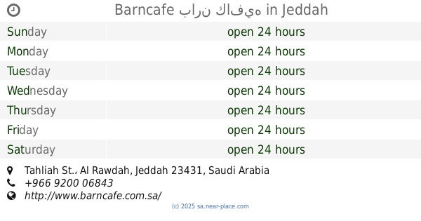
Barncafe بارن كافيه
Tahliah St., Jeddah
Cafe
read more
1.008 km
Bonn enough
جدة
Cafe
read more
1.049 km
Bafarat Cafe
Al Abud, Jeddah
Cafe
read more
1.073 km
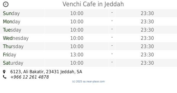
Venchi Cafe
6123 Ali Bakatir, Jeddah
Cafe
read more
📑
all categories
Accounting
Administrative area level 1
Airport
Amusement park
Aquarium
Art gallery
Atm
Bakery
Bank
Bar
Beauty salon
Bicycle store
Book store
Bowling alley
Bus station
Cafe
Campground
Car dealer
Car rental
Car repair
Car wash
Casino
Cemetery
Church
City hall
Clothing store
Colloquial area
Convenience store
Country
Courthouse
Dentist
Department store
Doctor
Electrician
Electronics store
Embassy
Finance
Fire station
Florist
Food
Funeral home
Furniture store
Gas station
General contractor
Grocery or supermarket
Gym
Hair care
Hardware store
Health
Hindu Temple
Home goods store
Hospital
Insurance agency
Intersection
Jewelry store
Laundry
Lawyer
Library
Light rail station
Liquor store
Local government office
Locality
Locksmith
Lodging
Meal delivery
Meal takeaway
Mosque
Movie rental
Movie theater
Moving company
Museum
Natural feature
Neighborhood
Night club
Painter
Park
Parking
Pet store
Pharmacy
Physiotherapist
Place of worship
Plumber
Point of interest
Police
Political
Post office
Premise
Real estate agency
Restaurant
Roofing contractor
Route
Rv park, camping
School
Shoe store
Shopping mall
Spa
Stadium
Storage
Store
Sublocality
Subpremise
Subway station
Supermarket
Taxi stand
Train station
Transit station
Travel agency
University
Veterinary care
Zoo
sublocality level 1
↑