Cafe nearby Zaman Cafe
Coronavirus disease (COVID-19) Situation
confirmed cases
841469
deaths
9646
Saudi Arabia
Cafe nearby Zaman Cafe
Zaman Cafe
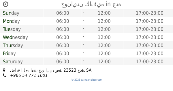
2760 Madinat Al Mawahib, 8292, Jeddah Saudi Arabia
contacts phone
:
+966
Latitude:
21.6109631
, Longitude:
39.1251063
read more
nearest Cafe
11 m
Makan Zaman Cafe
2760 مدينة المواهب، حي النهضة جدة 23523
Cafe
read more
16 m
Makan Zaman
Jeddah
Cafe
read more
283 m
جونايدن كافيه
شارع المناهج، حي النهضة، جدة
Cafe
read more
329 m
Taher's palace
2493 Ath Thaqafah Al Arabiyyah, An Nahdah District, Jeddah
Cafe
read more
392 m
Monsters icecream مونسترس ايسكريم
Hira Street, Jeddah
Cafe
read more
398 m
ايسكريم المها
8623 المناهج، حي النهضة جدة 23523
Cafe
read more
418 m
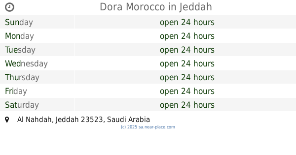
Dora Morocco
Jeddah
Cafe
read more
443 m
ايس كريم كوليتي
2959 حراء، حي الزهراء جدة 23522
Cafe
read more
485 m
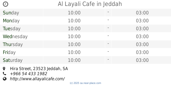
Al Layali Cafe
Hira Street, Jeddah
Cafe
read more
503 m
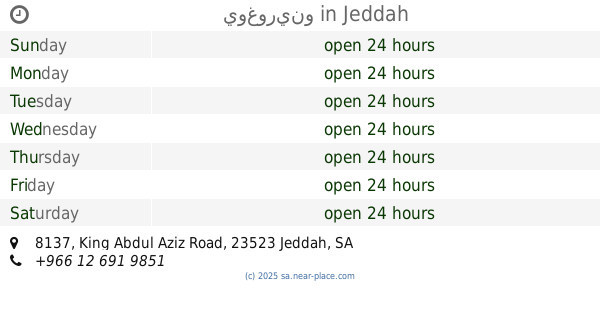
يوغورينو
طريق الملك، جدة
Cafe
read more
503 m
يوغورينو
8137 King Abdul Aziz Road, حي النهضة, Jeddah
Cafe
read more
530 m
الزهراء.جدة
Jeddah
Cafe
read more
566 m
او ماي بنز O My Buns
Jeddah
Cafe
read more
687 m
Saad Eddin Express
King Abdul Aziz Road, Jeddah
Cafe
read more
851 m
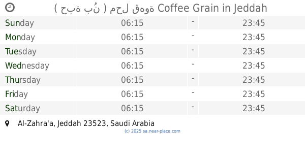
( حبة بُن ) محل قهوة Coffee Grain
Jeddah
Cafe
read more
900 m
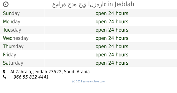
عمارة جده حي الزهراء
Jeddah
Cafe
read more
908 m
مقهى رؤيا
Jeddah
Cafe
read more
1.02 km
Dunkin Donuts
3740 Hira Street, Jeddah
Cafe
read more
1.045 km
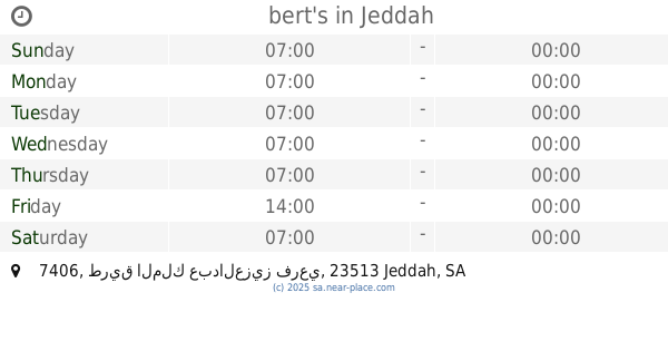
bert's
7406 طريق الملك عبدالعزيز فرعي, Ash Shati District,, Jeddah
Cafe
read more
1.077 km
ديوانية أبوحمد
Jeddah
Cafe
read more
1.147 km
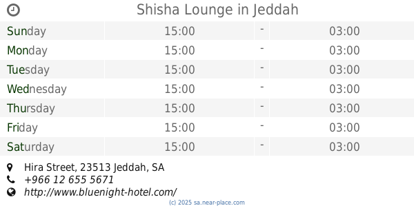
Shisha Lounge
Hira Street, Jeddah
Cafe
read more
1.149 km
Coffee and people
3136-3524 Abdullah Ghazi, Jeddah
Cafe
read more
1.152 km
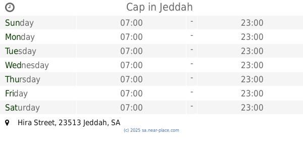
Cap
Hira Street, Ash Shati 3039, Jeddah
Cafe
read more
1.222 km
موكاتشينو
Jeddah
Cafe
read more
1.222 km
Mochachino JM-19
Hira Street, Jeddah
Cafe
read more
📑
all categories
Accounting
Administrative area level 1
Airport
Amusement park
Aquarium
Art gallery
Atm
Bakery
Bank
Bar
Beauty salon
Bicycle store
Book store
Bowling alley
Bus station
Cafe
Campground
Car dealer
Car rental
Car repair
Car wash
Casino
Cemetery
Church
City hall
Clothing store
Colloquial area
Convenience store
Country
Courthouse
Dentist
Department store
Doctor
Electrician
Electronics store
Embassy
Finance
Fire station
Florist
Food
Funeral home
Furniture store
Gas station
General contractor
Grocery or supermarket
Gym
Hair care
Hardware store
Health
Hindu Temple
Home goods store
Hospital
Insurance agency
Intersection
Jewelry store
Laundry
Lawyer
Library
Light rail station
Liquor store
Local government office
Locality
Locksmith
Lodging
Meal delivery
Meal takeaway
Mosque
Movie rental
Movie theater
Moving company
Museum
Natural feature
Neighborhood
Night club
Painter
Park
Parking
Pet store
Pharmacy
Physiotherapist
Place of worship
Plumber
Point of interest
Police
Political
Post office
Premise
Real estate agency
Restaurant
Roofing contractor
Route
Rv park, camping
School
Shoe store
Shopping mall
Spa
Stadium
Storage
Store
Sublocality
Subpremise
Subway station
Supermarket
Taxi stand
Train station
Transit station
Travel agency
University
Veterinary care
Zoo
sublocality level 1
↑