Clothing store nearby Red Tag
Coronavirus disease (COVID-19) Situation
confirmed cases
841469
deaths
9646
Saudi Arabia
Clothing store nearby Red Tag
Red Tag
267, 26513, Taif, SA Arabia Saudyjska
contacts phone
:
+966
website:
www.redtag-stores.com
Latitude:
21.2597412
, Longitude:
40.4093349
larger map & directions
read more
nearest Clothing store
225 m
Oud Elite
غيلان بن عمرو, Taif
Clothing store
read more
351 m
Bedoon Essm
عباس بن علقمة, Taif Renaissense Mall, Taif
Clothing store
read more
381 m
إيفانز
Taif
Clothing store
read more
384 m
نكست
Taif
Clothing store
read more
391 m
ذي بودي شوب
مركز شهار، شارع شهار، حي شهار، الطائف
Clothing store
read more
391 m
مكياجي
شارع عطارد بن حاجب ، حي شهار، الطائف
Clothing store
read more
394 m
نعومي
شارع شهار، حي شهار، الطائف
Clothing store
read more
395 m
بدون اسم
شارع شهار، حي شهار، الطائف
Clothing store
read more
397 m
أجمل
شارع شهار، حي شهار، الطائف
Clothing store
read more
402 m
Next
شارع شهار، حي شهار، الطائف
Clothing store
read more
402 m
إيفانز
شارع شهار ، حي شهار، الطائف
Clothing store
read more
402 m
باث & بودي وركس
شارع شهار، حي شهار، الطائف
Clothing store
read more
426 m
New Mark
7476 Shehar, Shihar, Taif 26513 2099 Shehar, Taif
Clothing store
read more
461 m
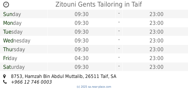
Zitouni Gents Tailoring
8753 Hamzah Bin Abdul Muttalib, Taif
Clothing store
read more
489 m
Naba Al Ateeb
Taif
Clothing store
read more
502 m
Loran Cotton
Taif
Clothing store
read more
507 m
Lami Cherokee
267, Taif
Clothing store
read more
512 m
W&T
Taif
Clothing store
read more
516 m
Wallis
7408 Shehar, Taif
Clothing store
read more
520 m
إف جي فور
2191, 7410, Taif
Clothing store
read more
521 m
مشغل لمى
طريق الملك عبدالله، حي العودة، الطائف
Clothing store
read more
525 m
الهندام الطبي
شارع شهار، حي شهار، الطائف
Clothing store
read more
526 m
La Senza
267, 7410, Taif
Clothing store
read more
527 m
العيدروس للمراييل المدرسيه
7888 Ali Ibn Al Khatab, Taif
Clothing store
read more
528 m
العيدروس للمراييل
7898 Ali Ibn Al Khatab, Taif
Clothing store
read more
📑
all categories
Accounting
Administrative area level 1
Airport
Amusement park
Aquarium
Art gallery
Atm
Bakery
Bank
Bar
Beauty salon
Bicycle store
Book store
Bowling alley
Bus station
Cafe
Campground
Car dealer
Car rental
Car repair
Car wash
Casino
Cemetery
Church
City hall
Clothing store
Colloquial area
Convenience store
Country
Courthouse
Dentist
Department store
Doctor
Electrician
Electronics store
Embassy
Finance
Fire station
Florist
Food
Funeral home
Furniture store
Gas station
General contractor
Grocery or supermarket
Gym
Hair care
Hardware store
Health
Hindu Temple
Home goods store
Hospital
Insurance agency
Intersection
Jewelry store
Laundry
Lawyer
Library
Light rail station
Liquor store
Local government office
Locality
Locksmith
Lodging
Meal delivery
Meal takeaway
Mosque
Movie rental
Movie theater
Moving company
Museum
Natural feature
Neighborhood
Night club
Painter
Park
Parking
Pet store
Pharmacy
Physiotherapist
Place of worship
Plumber
Point of interest
Police
Political
Post office
Premise
Real estate agency
Restaurant
Roofing contractor
Route
Rv park, camping
School
Shoe store
Shopping mall
Spa
Stadium
Storage
Store
Sublocality
Subpremise
Subway station
Supermarket
Taxi stand
Train station
Transit station
Travel agency
University
Veterinary care
Zoo
sublocality level 1
↑