Florist nearby دنيا الورود
Coronavirus disease (COVID-19) Situation
confirmed cases
841469
deaths
9646
Saudi Arabia
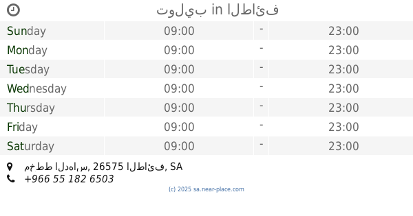
Florist nearby دنيا الورود
دنيا الورود
8721, Taif Saudi Arabien
contacts phone
:
+966
Latitude:
21.4444592
, Longitude:
40.5059385
read more
nearest Florist
549 m
توليب
مخطط الدهاس، الطائف
Florist
read more
1.866 km
مؤسسة مشاتل الصبار
الطائف
Florist
read more
1.934 km
أزهار سدن
شارع الستين، الحوية، الطائف
Florist
read more
2.373 km
مملكة الورد للهدايا
طريق سوق الماشية، الحوية، الطائف
Florist
read more
2.42 km
Spring Rose زهور الربيع
Taif
Florist
read more
2.657 km
Chapter Two
مخطط بدر، الطائف
Florist
read more
3.147 km
اوركيد
شارع الأمير محمد، حي الحوية، الطائف
Florist
read more
18.641 km
رنيم للزهور
طريق المطار, Taif
Florist
read more
19.561 km
Rowa'e Alward
7085 Al Qamariyyah, Taif
Florist
read more
19.6 km
وردتي
6992 Al Qamariyyah, Taif
Florist
read more
21.658 km
مركز الورود
شارع عبد الله بن العباس، الطائف
Florist
read more
21.911 km
مركز زهور بن بكر
Taif
Florist
read more
21.918 km
رد روز
حي السلامة، الطائف
Florist
read more
22.122 km
روز لاند
حي السلامة، الطائف
Florist
read more
22.123 km
أميرة الورد
5377 As Salamah, 9631, Taif
Florist
read more
22.135 km
أغصان التوليب
حي السلامة، الطائف
Florist
read more
22.168 km
عالم الزهور
حي السلامة، الطائف
Florist
read more
22.176 km
حكاية ورود
حي السلامة، الطائف
Florist
read more
22.456 km
زهرة جنى
8048 Ash Shutbah, Taif
Florist
read more
22.536 km
ورد الجوري
8189 Shehar, Taif
Florist
read more
22.551 km
روز غالري
شارع القمرية, Taif
Florist
read more
22.555 km
لمسات محترف
5860 Abdullah Ibn Amr, Taif
Florist
read more
22.562 km
the best gift
7956 Ali Ibn Al Khatab, Taif
Florist
read more
22.614 km
بائع الورد
حي شهار، الطائف
Florist
read more
22.737 km
بصمة حفلة
An Nuzhah An Nuzhah, Taif
Florist
read more
📑
all categories
Accounting
Administrative area level 1
Airport
Amusement park
Aquarium
Art gallery
Atm
Bakery
Bank
Bar
Beauty salon
Bicycle store
Book store
Bowling alley
Bus station
Cafe
Campground
Car dealer
Car rental
Car repair
Car wash
Casino
Cemetery
Church
City hall
Clothing store
Colloquial area
Convenience store
Country
Courthouse
Dentist
Department store
Doctor
Electrician
Electronics store
Embassy
Finance
Fire station
Florist
Food
Funeral home
Furniture store
Gas station
General contractor
Grocery or supermarket
Gym
Hair care
Hardware store
Health
Hindu Temple
Home goods store
Hospital
Insurance agency
Intersection
Jewelry store
Laundry
Lawyer
Library
Light rail station
Liquor store
Local government office
Locality
Locksmith
Lodging
Meal delivery
Meal takeaway
Mosque
Movie rental
Movie theater
Moving company
Museum
Natural feature
Neighborhood
Night club
Painter
Park
Parking
Pet store
Pharmacy
Physiotherapist
Place of worship
Plumber
Point of interest
Police
Political
Post office
Premise
Real estate agency
Restaurant
Roofing contractor
Route
Rv park, camping
School
Shoe store
Shopping mall
Spa
Stadium
Storage
Store
Sublocality
Subpremise
Subway station
Supermarket
Taxi stand
Train station
Transit station
Travel agency
University
Veterinary care
Zoo
sublocality level 1
↑