Gas station nearby Al-Harthi Petrol Station
Coronavirus disease (COVID-19) Situation
confirmed cases
841469
deaths
9646
Saudi Arabia
Gas station nearby Al-Harthi Petrol Station
Al-Harthi Petrol Station
Abu Bakr Alsiddiq Street, Dammam Saudi Arabia
contacts phone
:
+966
Latitude:
26.4118965
, Longitude:
50.0331384
read more
nearest Gas station
678 m
محطة وقود
Dammam
Gas station
read more
681 m
ALDREES Petrol Pump
Dammam
Gas station
read more
837 m
محطة الصيعري
2296 الخوارزمي, 8327, Dammam
Gas station
read more
838 m
محطه بنزين كلينكس
Dammam
Gas station
read more
844 m
Petrol Station
2296 الخوارزمي, 8327, Dammam
Gas station
read more
1.366 km
Sacco station
King Saud Street, Dammam
Gas station
read more
1.366 km
Sasco station
King Saud Street, Dammam
Gas station
read more
1.698 km
محطة البركة
4526 King Saud Street, 7186،, Dammam
Gas station
read more
1.784 km
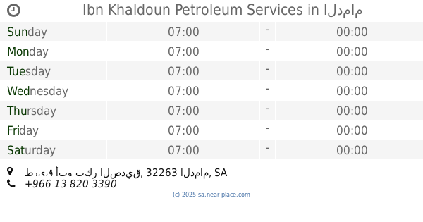
Ibn Khaldoun Petroleum Services
طريق أبو بكر الصديق، الدمام
Gas station
read more
1.808 km
Aldrees
Omar Ibn Al Khattab, Dammam
Gas station
read more
1.809 km
Petrol Station
9050 Umar Ibn Al Khattab, Dammam
Gas station
read more
1.818 km
Halsan station
Dammam
Gas station
read more
1.835 km
Drees Petroleum Services
Dammam
Gas station
read more
1.893 km
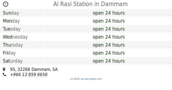
Al Rasi Station
95, Dammam
Gas station
read more
1.902 km
شركة منظومة الوقود
شارع أبوبكر الصديق، حي النور، الدمام
Gas station
read more
1.927 km
محطة سحابة النور
Unnamed Road, النور،, Dammam
Gas station
read more
1.965 km
Qarni Gas Station
95, Dammam
Gas station
read more
1.972 km
Aldrees
95, Dammam
Gas station
read more
1.973 km
AlDrees Petrol Pump
King Fahd Road, Dammam
Gas station
read more
2.026 km
محطة مزيا
شارع الملك سعود،, Dammam
Gas station
read more
2.036 km
Al Drees
King Fahd Road, Dammam
Gas station
read more
2.063 km
تلميع سيارات
المنار،, Dammam
Gas station
read more
2.071 km
محطة شازكو 2
Dammam
Gas station
read more
2.079 km
Al Drees
ابو الحسن الدرامي, Dammam
Gas station
read more
2.079 km
Al Drees
ابو الحسن الدرامي، الدمام
Gas station
read more
📑
all categories
Accounting
Administrative area level 1
Airport
Amusement park
Aquarium
Art gallery
Atm
Bakery
Bank
Bar
Beauty salon
Bicycle store
Book store
Bowling alley
Bus station
Cafe
Campground
Car dealer
Car rental
Car repair
Car wash
Casino
Cemetery
Church
City hall
Clothing store
Colloquial area
Convenience store
Country
Courthouse
Dentist
Department store
Doctor
Electrician
Electronics store
Embassy
Finance
Fire station
Florist
Food
Funeral home
Furniture store
Gas station
General contractor
Grocery or supermarket
Gym
Hair care
Hardware store
Health
Hindu Temple
Home goods store
Hospital
Insurance agency
Intersection
Jewelry store
Laundry
Lawyer
Library
Light rail station
Liquor store
Local government office
Locality
Locksmith
Lodging
Meal delivery
Meal takeaway
Mosque
Movie rental
Movie theater
Moving company
Museum
Natural feature
Neighborhood
Night club
Painter
Park
Parking
Pet store
Pharmacy
Physiotherapist
Place of worship
Plumber
Point of interest
Police
Political
Post office
Premise
Real estate agency
Restaurant
Roofing contractor
Route
Rv park, camping
School
Shoe store
Shopping mall
Spa
Stadium
Storage
Store
Sublocality
Subpremise
Subway station
Supermarket
Taxi stand
Train station
Transit station
Travel agency
University
Veterinary care
Zoo
sublocality level 1
↑