Gas station nearby Hamit
Saudi Arabia
Gas station nearby Hamit
Hamit
شارع الآصال،, 24372, Mecca, SA Saudi Arabia
contacts phone
:
+235 90 83 38 28
Latitude:
21.3602444
, Longitude:
39.8968402
larger map & directions
read more
nearest Gas station
288 m
محطة الراية نفط للمواد البترولية
مكة
Gas station
read more
292 m
Ar-rayah Petrol Station
4643 طريق الطائف, Mecca
Gas station
read more
296 m
محطة الراية نفط
4703 طريق الطائف, 8677, Mecca
Gas station
read more
472 m
محطة مجمع الدوائر الحكومية
Mecca
Gas station
read more
799 m
Alfatih
Mecca
Gas station
read more
838 m
محطة عصمت للمحروقات
Ibrahim Al Juffali, Mecca
Gas station
read more
1.109 km
Station complex Awali
5456 طريق الطائف, Mecca
Gas station
read more
1.156 km
Public Security Petrol - Branch Station
3652 طريق رقم 2, Mecca
Gas station
read more
1.375 km
محطة البوابة
Ibrahim Al Juffali, Mecca
Gas station
read more
1.512 km
محطة الحي الراقي
Mecca
Gas station
read more
1.536 km
مغسلة العوالي الحديثة
مكة
Gas station
read more
1.988 km
Petrol Station Awali
شارع الأبصار, Mecca
Gas station
read more
2.147 km
مغسلة ومركز تلميع مسارات لخدمات السيارات
Mecca
Gas station
read more
2.304 km
Alfath Gas Station
Ibrahim Al Juffali, Mecca
Gas station
read more
2.304 km
محطة الفتح العوالي
2104 شارع إبراهيم الجفالي، العوالي، مكة 24372
Gas station
read more
3.425 km
مركز السعد لخدمه السيارات
4th Ring Road, Mecca
Gas station
read more
3.712 km
محطة مجنوني
Mecca
Gas station
read more
3.712 km
Samarec Gas Station
Mecca
Gas station
read more
3.882 km
Esmat station
Mecca
Gas station
read more
3.882 km
Esmat Gas Station
Mecca
Gas station
read more
3.891 km
محطة وقود ممتاز
3060 Muzdalifah Road, 6053, Mecca
Gas station
read more
4.167 km
محطة عرنة
طريق الحسينية، حي الحسينية، مكة
Gas station
read more
4.358 km
Mona Station 1
7574 King Abdul Aziz Road, Mecca
Gas station
read more
4.374 km
Rawabi Al Azizia Car Services Center (publish)
Mecca
Gas station
read more
4.682 km
محطة جنوب الحسينية
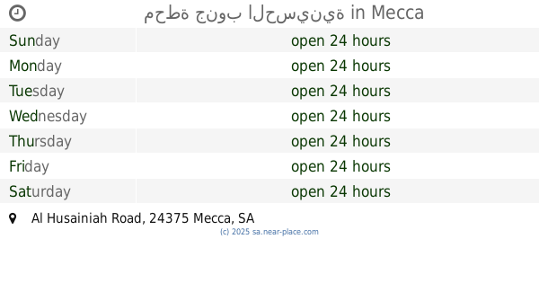
Al Husainiah Road, Mecca
Gas station
read more
📑
all categories
Accounting
Administrative area level 1
Airport
Amusement park
Aquarium
Art gallery
Atm
Bakery
Bank
Bar
Beauty salon
Bicycle store
Book store
Bowling alley
Bus station
Cafe
Campground
Car dealer
Car rental
Car repair
Car wash
Casino
Cemetery
Church
City hall
Clothing store
Colloquial area
Convenience store
Country
Courthouse
Dentist
Department store
Doctor
Electrician
Electronics store
Embassy
Finance
Fire station
Florist
Food
Funeral home
Furniture store
Gas station
General contractor
Grocery or supermarket
Gym
Hair care
Hardware store
Health
Hindu Temple
Home goods store
Hospital
Insurance agency
Intersection
Jewelry store
Laundry
Lawyer
Library
Light rail station
Liquor store
Local government office
Locality
Locksmith
Lodging
Meal delivery
Meal takeaway
Mosque
Movie rental
Movie theater
Moving company
Museum
Natural feature
Neighborhood
Night club
Painter
Park
Parking
Pet store
Pharmacy
Physiotherapist
Place of worship
Plumber
Point of interest
Police
Political
Post office
Premise
Real estate agency
Restaurant
Roofing contractor
Route
Rv park, camping
School
Shoe store
Shopping mall
Spa
Stadium
Storage
Store
Sublocality
Subpremise
Subway station
Supermarket
Taxi stand
Train station
Transit station
Travel agency
University
Veterinary care
Zoo
sublocality level 1
↑