Gas station nearby مركز ابراج الكرستال لغيار الزيوت ١٠
Saudi Arabia
Gas station nearby مركز ابراج الكرستال لغيار الزيوت ١٠
مركز ابراج الكرستال لغيار الزيوت ١٠
Abha Saudi Arabia
contacts phone
:
+966
Latitude:
18.2107109
, Longitude:
42.656328
read more
nearest Gas station
2.552 km
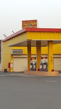
محطة السلام
King Abdullah Road, Abha
Gas station
read more
2.861 km
Petrol station
King Abdullah Road, Abha
Gas station
read more
2.862 km
محطة الصعيري
طريق الملك عبد الله، أبها
Gas station
read more
2.905 km
مجمع سعيد بن محمد ال عازب
7861 أبها 62586
Gas station
read more
2.907 km
Petroleum Pearl Airport
Abha
Gas station
read more
3.153 km
مناحل ابوسلطان. وبن حترش
Abha
Gas station
read more
3.792 km
سهل
King Abdullah Road, Khamis Mushait
Gas station
read more
4.697 km
محطة امان التنمية 2
Prince Sultan Road, خميس مشيط, Khamis Mushait
Gas station
read more
4.977 km
مجمع ومحطة الوادي
آل السريع
Gas station
read more
4.98 km
Petrol station
2120, آل السريع
Gas station
read more
5.19 km
Al-Amer Petrol Station
Abha
Gas station
read more
5.326 km
Gas Station Abu Dabeel
Abha
Gas station
read more
5.578 km
برجيستون الطلائع ابها
Abha
Gas station
read more
5.656 km
الطلائع كفرات بريجستون
Abha
Gas station
read more
5.664 km
محطة العامر
Abha
Gas station
read more
5.695 km
محطه زيتي
10, Abha
Gas station
read more
5.701 km
Petrol station
2727 King Fahd Road, Abha
Gas station
read more
5.754 km
Petrol Station
King Abdullah Rd
Gas station
read more
5.842 km
محطة بن مضحية للمحروقات
10, Abha
Gas station
read more
5.847 km
محطةبن مضحية
Abha
Gas station
read more
5.922 km
Petrol station
2120
Gas station
read more
6.233 km
Sahel
10, Abha
Gas station
read more
6.242 km
Ben Ghamiah station
King Fahd Branch Road, Abha
Gas station
read more
6.522 km
Buraiki Petrol Station
King Fahd Road, Khamis Mushait
Gas station
read more
6.524 km
محطة البريكي للمحروقات
طريق أبها، خميس مشيط
Gas station
read more
📑
all categories
Accounting
Administrative area level 1
Airport
Amusement park
Aquarium
Art gallery
Atm
Bakery
Bank
Bar
Beauty salon
Bicycle store
Book store
Bowling alley
Bus station
Cafe
Campground
Car dealer
Car rental
Car repair
Car wash
Casino
Cemetery
Church
City hall
Clothing store
Colloquial area
Convenience store
Country
Courthouse
Dentist
Department store
Doctor
Electrician
Electronics store
Embassy
Finance
Fire station
Florist
Food
Funeral home
Furniture store
Gas station
General contractor
Grocery or supermarket
Gym
Hair care
Hardware store
Health
Hindu Temple
Home goods store
Hospital
Insurance agency
Intersection
Jewelry store
Laundry
Lawyer
Library
Light rail station
Liquor store
Local government office
Locality
Locksmith
Lodging
Meal delivery
Meal takeaway
Mosque
Movie rental
Movie theater
Moving company
Museum
Natural feature
Neighborhood
Night club
Painter
Park
Parking
Pet store
Pharmacy
Physiotherapist
Place of worship
Plumber
Point of interest
Police
Political
Post office
Premise
Real estate agency
Restaurant
Roofing contractor
Route
Rv park, camping
School
Shoe store
Shopping mall
Spa
Stadium
Storage
Store
Sublocality
Subpremise
Subway station
Supermarket
Taxi stand
Train station
Transit station
Travel agency
University
Veterinary care
Zoo
sublocality level 1
↑