Gas station nearby Petrol station
Coronavirus disease (COVID-19) Situation
confirmed cases
841469
deaths
9646
Saudi Arabia
Gas station nearby Petrol station
Petrol station
211, 63453, Aseer Province, SA Saudi Arabia
contacts phone
:
+966
Latitude:
18.3016982
, Longitude:
42.2271243
larger map & directions
read more
nearest Gas station
427 m
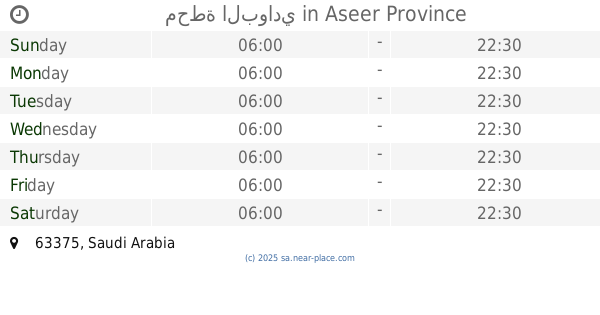
محطة البركة
211
Gas station
read more
427 m
Petroleum services Station
Gas station
read more
3.842 km
Dura Station
Al Jarf
Gas station
read more
7.053 km
ورشة ابو جهاد السوري
211, Al Jarf
Gas station
read more
8.007 km
Petrol station
211, Al Jarf
Gas station
read more
8.671 km
Petrol station
2442
Gas station
read more
9.396 km
Deyaar fuel station Ghanameh
Al Ous'
Gas station
read more
11.393 km
Petrol station
Al Ous'
Gas station
read more
15.41 km
محطة البوادي
Gas station
read more
15.79 km
Petrol Station Souda
Gas station
read more
17.009 km
محطه
Gas station
read more
18.271 km
مجمع ضواحي السودة للمواد البترولية
Aseer
Gas station
read more
20.713 km
Aldrees
Gas station
read more
21.451 km
السوده القوز
Gas station
read more
21.744 km
محطة المصيف
Abha
Gas station
read more
23.556 km
محطة بنزين
Habeel
Gas station
read more
24.623 km
Gas station Masa
Abha
Gas station
read more
24.953 km
مجمع الأطلال
Abha
Gas station
read more
25.837 km
محطه وقود
Saudi Arabia
Gas station
read more
26.352 km
محطة الارتفاع
Gas station
read more
26.616 km
محطة الفايز
Abha
Gas station
read more
26.634 km
بنشر الفايز
Jeddah
Gas station
read more
26.723 km
Gas station
2528, Abha
Gas station
read more
26.769 km
محل غاز و تعبئة
Abha
Gas station
read more
27.636 km
محطة الأصالة
Al Soudah Road, Abha
Gas station
read more
📑
all categories
Accounting
Administrative area level 1
Airport
Amusement park
Aquarium
Art gallery
Atm
Bakery
Bank
Bar
Beauty salon
Bicycle store
Book store
Bowling alley
Bus station
Cafe
Campground
Car dealer
Car rental
Car repair
Car wash
Casino
Cemetery
Church
City hall
Clothing store
Colloquial area
Convenience store
Country
Courthouse
Dentist
Department store
Doctor
Electrician
Electronics store
Embassy
Finance
Fire station
Florist
Food
Funeral home
Furniture store
Gas station
General contractor
Grocery or supermarket
Gym
Hair care
Hardware store
Health
Hindu Temple
Home goods store
Hospital
Insurance agency
Intersection
Jewelry store
Laundry
Lawyer
Library
Light rail station
Liquor store
Local government office
Locality
Locksmith
Lodging
Meal delivery
Meal takeaway
Mosque
Movie rental
Movie theater
Moving company
Museum
Natural feature
Neighborhood
Night club
Painter
Park
Parking
Pet store
Pharmacy
Physiotherapist
Place of worship
Plumber
Point of interest
Police
Political
Post office
Premise
Real estate agency
Restaurant
Roofing contractor
Route
Rv park, camping
School
Shoe store
Shopping mall
Spa
Stadium
Storage
Store
Sublocality
Subpremise
Subway station
Supermarket
Taxi stand
Train station
Transit station
Travel agency
University
Veterinary care
Zoo
sublocality level 1
↑