Gas station nearby Sayari Gas Station
Coronavirus disease (COVID-19) Situation
confirmed cases
841469
deaths
9646
Saudi Arabia
Gas station nearby Sayari Gas Station
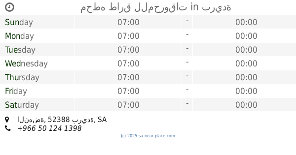
Sayari Gas Station
Al Iskan, Buraydah 52387, Saudi Arabia
contacts phone
:
+966
Latitude:
26.396331
, Longitude:
43.9460723
larger map & directions
read more
nearest Gas station
20 m
محطه بنزين
طريق الملك عبدالله،، بريدة
Gas station
read more
1.085 km
Al Hamra Gas Station
Buraydah
Gas station
read more
1.09 km
Red station
7013, Buraydah
Gas station
read more
1.092 km
محطه طارق للمحروقات
النهضة، بريدة
Gas station
read more
1.34 km
Aldrees
King Khalid Road, Buraydah
Gas station
read more
1.34 km
محطه الادريس للخدمات البتروليه
King Khalid Road, Buraydah
Gas station
read more
1.463 km
Naft
Uthman Ibn Affan Road, Buraydah
Gas station
read more
1.478 km
محطة الحسون
8942 طريق عثمان بن عفان،, 2589, Buraydah
Gas station
read more
1.676 km
محطه الصيعري
6503, الجامعيين، 2651, Buraydah
Gas station
read more
1.906 km
Al Rawaf Gas Station
3927 Ali Ibn Abi Talib Road, Buraydah
Gas station
read more
1.938 km
Petrol station
Ali Ibn Abi Talib Road, Buraydah
Gas station
read more
1.992 km
Alsaiari
3363 Uthman Ibn Affan Road, مخطط الرواف،, Buraydah
Gas station
read more
2.015 km
Alkhemah Gas Station
Umar Ibn Al Khatab Road, Buraydah
Gas station
read more
2.096 km
محطة
Buraydah
Gas station
read more
2.097 km
Gas Station
Umar Ibn Al Khatab Road, Buraydah
Gas station
read more
2.116 km
مصدر النفط
الجامعيين 7321, Buraydah
Gas station
read more
2.116 km
Gas Station
الجامعيين 7321, Buraydah
Gas station
read more
2.171 km
محطة مريم
Umar Ibn Al Khatab Road, Buraydah
Gas station
read more
2.173 km
Al Jarallah Petrol Station
الحي الأخضر،, Buraydah
Gas station
read more
2.226 km
Gas station
5461, مخطط الرواف, Buraydah
Gas station
read more
2.226 km
Rayyan Gas Station
Buraydah
Gas station
read more
2.289 km
Petromin Express Al Munaif Buraida 1636
Buraydah
Gas station
read more
2.458 km
محطة وقود
الحي الأخضر، الورود،, Buraydah
Gas station
read more
2.539 km
Aldrees
7239-7285 Umar Ibn Al Khatab Road, Buraydah
Gas station
read more
2.539 km
محطه الدريس للخدمات البتروليه
7239-7285 Umar Ibn Al Khatab Road, Buraydah
Gas station
read more
📑
all categories
Accounting
Administrative area level 1
Airport
Amusement park
Aquarium
Art gallery
Atm
Bakery
Bank
Bar
Beauty salon
Bicycle store
Book store
Bowling alley
Bus station
Cafe
Campground
Car dealer
Car rental
Car repair
Car wash
Casino
Cemetery
Church
City hall
Clothing store
Colloquial area
Convenience store
Country
Courthouse
Dentist
Department store
Doctor
Electrician
Electronics store
Embassy
Finance
Fire station
Florist
Food
Funeral home
Furniture store
Gas station
General contractor
Grocery or supermarket
Gym
Hair care
Hardware store
Health
Hindu Temple
Home goods store
Hospital
Insurance agency
Intersection
Jewelry store
Laundry
Lawyer
Library
Light rail station
Liquor store
Local government office
Locality
Locksmith
Lodging
Meal delivery
Meal takeaway
Mosque
Movie rental
Movie theater
Moving company
Museum
Natural feature
Neighborhood
Night club
Painter
Park
Parking
Pet store
Pharmacy
Physiotherapist
Place of worship
Plumber
Point of interest
Police
Political
Post office
Premise
Real estate agency
Restaurant
Roofing contractor
Route
Rv park, camping
School
Shoe store
Shopping mall
Spa
Stadium
Storage
Store
Sublocality
Subpremise
Subway station
Supermarket
Taxi stand
Train station
Transit station
Travel agency
University
Veterinary care
Zoo
sublocality level 1
↑