Gas station nearby Wasit station
Coronavirus disease (COVID-19) Situation
confirmed cases
841469
deaths
9646
Saudi Arabia
Gas station nearby Wasit station
Wasit station
Taif Arabia Saudyjska
contacts phone
:
+966
Latitude:
21.4739506
, Longitude:
40.4684937
read more
nearest Gas station
801 m
Alvaih station
5345, 8974, Taif
Gas station
read more
922 m
Marhaba Station
6594, 4735, Taif
Gas station
read more
963 m
محطة المسرات للمحروقات البترولية مندي الهجرين
As Sail Road, Taif
Gas station
read more
1.798 km
Jewel Taif station
Makkah Al Mukarramah Road, 5591, Taif
Gas station
read more
2.072 km
Reconcile station
شارع ريحة, Taif
Gas station
read more
2.138 km
محطة الفهد
Taif
Gas station
read more
2.184 km
محطة الخالدية 1
9200, Taif
Gas station
read more
2.244 km
محطة الجزيرة
7991, 2340, Taif
Gas station
read more
2.691 km
محطة المعمورة
Taif
Gas station
read more
2.769 km
Alzoran station
شارع مثملة, 26312, Taif
Gas station
read more
2.79 km
AL IDREES Petrol Station
8378, 4627,, Taif
Gas station
read more
2.811 km
Khalidiya station
Makkah Al Mukarramah Road, Taif
Gas station
read more
2.861 km
Petrol station
شارع مثملة, Taif
Gas station
read more
3.15 km
Sultana station
Taif
Gas station
read more
3.363 km
محطة الأصالة
Makkah Al Mukarramah Road, Taif
Gas station
read more
3.402 km
AlShaibani station
Taif
Gas station
read more
3.828 km
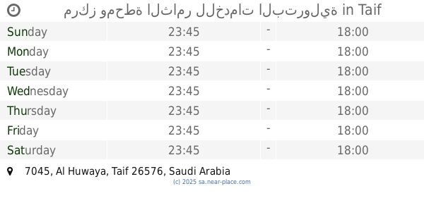
مركز ومحطة الثامر للخدمات البترولية
7045, Taif
Gas station
read more
3.835 km
Mica Theyabi station
طريق سوق الماشية, Taif
Gas station
read more
3.868 km
محطة الزيادي للمواد البترولية
Taif
Gas station
read more
4.075 km
Sports stadium station
Taif
Gas station
read more
4.25 km
Abdali station
Taif
Gas station
read more
4.315 km
محطة الدريس
Taif
Gas station
read more
4.321 km
Petrol station
Makkah Al Mukarramah Road, Taif
Gas station
read more
4.339 km
Petrol Station Idris
Taif
Gas station
read more
4.511 km
Sasco station
7987, Taif
Gas station
read more
📑
all categories
Accounting
Administrative area level 1
Airport
Amusement park
Aquarium
Art gallery
Atm
Bakery
Bank
Bar
Beauty salon
Bicycle store
Book store
Bowling alley
Bus station
Cafe
Campground
Car dealer
Car rental
Car repair
Car wash
Casino
Cemetery
Church
City hall
Clothing store
Colloquial area
Convenience store
Country
Courthouse
Dentist
Department store
Doctor
Electrician
Electronics store
Embassy
Finance
Fire station
Florist
Food
Funeral home
Furniture store
Gas station
General contractor
Grocery or supermarket
Gym
Hair care
Hardware store
Health
Hindu Temple
Home goods store
Hospital
Insurance agency
Intersection
Jewelry store
Laundry
Lawyer
Library
Light rail station
Liquor store
Local government office
Locality
Locksmith
Lodging
Meal delivery
Meal takeaway
Mosque
Movie rental
Movie theater
Moving company
Museum
Natural feature
Neighborhood
Night club
Painter
Park
Parking
Pet store
Pharmacy
Physiotherapist
Place of worship
Plumber
Point of interest
Police
Political
Post office
Premise
Real estate agency
Restaurant
Roofing contractor
Route
Rv park, camping
School
Shoe store
Shopping mall
Spa
Stadium
Storage
Store
Sublocality
Subpremise
Subway station
Supermarket
Taxi stand
Train station
Transit station
Travel agency
University
Veterinary care
Zoo
sublocality level 1
↑