Gym nearby Jeddah Dhahban
Coronavirus disease (COVID-19) Situation
confirmed cases
841469
deaths
9646
Saudi Arabia
Gym nearby Jeddah Dhahban
Jeddah Dhahban
Unnamed Road,, Dhahban 23868, Saudi Arabia
contacts phone
:
+966 57 081 0866
Latitude:
21.948817
, Longitude:
39.0901048
larger map & directions
read more
nearest Gym
Jeddah Dhahban
Unnamed Road,, Dahaban
Gym
read more
11.227 km
Guo special tasks and duties
Dhahaban, شمال, Jeddah
Gym
read more
15.418 km
استراحة الهنا رقم ١
Jeddah
Gym
read more
15.476 km
حلبه سباق سيارات
Jeddah
Gym
read more
16.491 km
Lion Club
Jeddah
Gym
read more
16.496 km
Liu Dimo Sports Club
Jeddah
Gym
read more
16.502 km
تايكوندو شبكة بطل العرب
طريق المدينة المنورة، جدة
Gym
read more
17.017 km
Stadium Dream Theater
7484, حي طيبة, Jeddah
Gym
read more
17.06 km
استراحة عسفان
جدة
Gym
read more
17.076 km
Equestrian Club Jeddah
Jeddah
Gym
read more
17.395 km
GYM Azzam Compound
Azzam Compound, Jeddah
Gym
read more
17.885 km
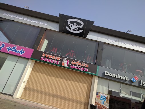
Network Arab Champion Center
Jeddah
Gym
read more
17.928 km
اسطبل النواوي الخاص
جدة
Gym
read more
17.929 km
al nawaway stable
Jeddah
Gym
read more
18.183 km
ذا تراك
محطة الرحيلي، طريق المدينة المنورة،, Jeddah
Gym
read more
18.233 km
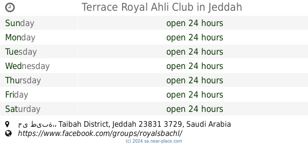
Terrace Royal Ahli Club
7145, حي طيبة،, Jeddah
Gym
read more
18.337 km
نادي مهرة للفروسية النسائية
Unnamed Road, الفردوس،, Jeddah
Gym
read more
18.548 km
استراحة وملعب النور
Jeddah
Gym
read more
18.61 km
استراحة نصار العلوي جدة
Unnamed Road 23788, Jeddah
Gym
read more
18.64 km
ااستراحة / نصار العلوي
طريق عسفان، جدة
Gym
read more
18.936 km
استراحة الدكتور فايز فلمبان
Unnamed Road, Jeddah
Gym
read more
19.73 km
اورا فتنس سنتر
Prince Naif Road, Jeddah
Gym
read more
19.734 km
مركز الهالة العالمية للرياضة النسائية
Prince Naif Road, Jeddah
Gym
read more
19.841 km
Al-Saeed neighborhood walkway
Al Saeed District, Jeddah
Gym
read more
20.334 km
ملاعب جدة بالحمدانية
23762, Jeddah
Gym
read more
📑
all categories
Accounting
Administrative area level 1
Airport
Amusement park
Aquarium
Art gallery
Atm
Bakery
Bank
Bar
Beauty salon
Bicycle store
Book store
Bowling alley
Bus station
Cafe
Campground
Car dealer
Car rental
Car repair
Car wash
Casino
Cemetery
Church
City hall
Clothing store
Colloquial area
Convenience store
Country
Courthouse
Dentist
Department store
Doctor
Electrician
Electronics store
Embassy
Finance
Fire station
Florist
Food
Funeral home
Furniture store
Gas station
General contractor
Grocery or supermarket
Gym
Hair care
Hardware store
Health
Hindu Temple
Home goods store
Hospital
Insurance agency
Intersection
Jewelry store
Laundry
Lawyer
Library
Light rail station
Liquor store
Local government office
Locality
Locksmith
Lodging
Meal delivery
Meal takeaway
Mosque
Movie rental
Movie theater
Moving company
Museum
Natural feature
Neighborhood
Night club
Painter
Park
Parking
Pet store
Pharmacy
Physiotherapist
Place of worship
Plumber
Point of interest
Police
Political
Post office
Premise
Real estate agency
Restaurant
Roofing contractor
Route
Rv park, camping
School
Shoe store
Shopping mall
Spa
Stadium
Storage
Store
Sublocality
Subpremise
Subway station
Supermarket
Taxi stand
Train station
Transit station
Travel agency
University
Veterinary care
Zoo
sublocality level 1
↑