Gym nearby Wellness Center, Utilities & Technical Support Department
Coronavirus disease (COVID-19) Situation
confirmed cases
841469
deaths
9646
Saudi Arabia
Gym nearby Wellness Center, Utilities & Technical Support Department
Wellness Center, Utilities & Technical Support Department
Crane Court, 34471, Dhahran, SA Saudi Arabia
contacts phone
:
+966
Latitude:
26.3049113
, Longitude:
50.118151
larger map & directions
read more
nearest Gym
952 m
Spinning Club
Dhahran
Gym
read more
972 m
Schwinn Spinning Center
7440, 4100, Dhahran
Gym
read more
1.099 km
Yoga and Meditation Center
Karl Avenue, Dhahran
Gym
read more
1.222 km
Female Gym
Dhahran
Gym
read more
1.237 km
Aramco women gym
Dhahran
Gym
read more
1.252 km
Aramco ladies gym - kings
Dhahran
Gym
read more
1.649 km
Munirah Gym
2509, 7346, Dhahran
Gym
read more
1.661 km
النادي الرياضي بحي المنيرة
2487, Dhahran
Gym
read more
1.77 km
Cookie's
404 Date Way, Dhahran
Gym
read more
2.021 km
Dhahran Hills Gym
8237, 2738, Dhahran
Gym
read more
2.102 km
Sport complex
Berri Lane, Dhahran
Gym
read more
2.102 km
Soccer field
Berri Lane, Dhahran
Gym
read more
2.553 km
North Park Male Fitness Center
North Park Road, Dhahran
Gym
read more
2.563 km
Aramco North Park gym
Dhahran
Gym
read more
2.713 km
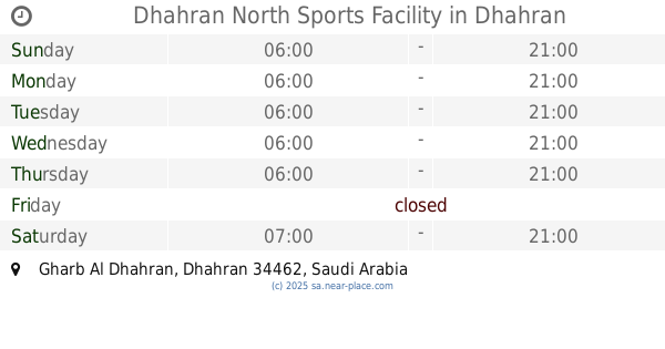
Dhahran North Sports Facility
Dhahran
Gym
read more
2.726 km
Building 11 (Main Gym)
4186, Dhahran
Gym
read more
2.726 km
Gymnasium (Building 11)
4186, Dhahran
Gym
read more
3.355 km
Building 36
3897, Dhahran
Gym
read more
3.392 km
University's main stadium
Dhahran
Gym
read more
4.548 km
بوابة ثانوية للحديقة
Dhahran
Gym
read more
5.035 km
Laith Fitness Center
Dhahran
Gym
read more
5.06 km
Волсы виолетта
Dhahran
Gym
read more
5.084 km
نادي كابيتانو | Capitano Club
الظهران
Gym
read more
5.158 km
Fitness Time
6966 King Saud Road, 2393, طريق الملك سعود،, Al Khobar
Gym
read more
5.162 km
Red Fitness Time
6966 طريق الملك سعود، العليا الخبر 34448 2393 King Saud Road, Al Khobar
Gym
read more
📑
all categories
Accounting
Administrative area level 1
Airport
Amusement park
Aquarium
Art gallery
Atm
Bakery
Bank
Bar
Beauty salon
Bicycle store
Book store
Bowling alley
Bus station
Cafe
Campground
Car dealer
Car rental
Car repair
Car wash
Casino
Cemetery
Church
City hall
Clothing store
Colloquial area
Convenience store
Country
Courthouse
Dentist
Department store
Doctor
Electrician
Electronics store
Embassy
Finance
Fire station
Florist
Food
Funeral home
Furniture store
Gas station
General contractor
Grocery or supermarket
Gym
Hair care
Hardware store
Health
Hindu Temple
Home goods store
Hospital
Insurance agency
Intersection
Jewelry store
Laundry
Lawyer
Library
Light rail station
Liquor store
Local government office
Locality
Locksmith
Lodging
Meal delivery
Meal takeaway
Mosque
Movie rental
Movie theater
Moving company
Museum
Natural feature
Neighborhood
Night club
Painter
Park
Parking
Pet store
Pharmacy
Physiotherapist
Place of worship
Plumber
Point of interest
Police
Political
Post office
Premise
Real estate agency
Restaurant
Roofing contractor
Route
Rv park, camping
School
Shoe store
Shopping mall
Spa
Stadium
Storage
Store
Sublocality
Subpremise
Subway station
Supermarket
Taxi stand
Train station
Transit station
Travel agency
University
Veterinary care
Zoo
sublocality level 1
↑