Hospital nearby Al- Hayat Hospital
Coronavirus disease (COVID-19) Situation
confirmed cases
841469
deaths
9646
Saudi Arabia
Hospital nearby Al- Hayat Hospital
Al- Hayat Hospital
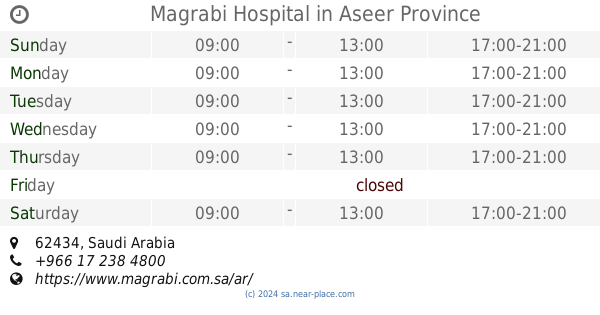
Unnamed Road 62434, Saudi Arabia
contacts phone
:
+966
Latitude:
18.2572599
, Longitude:
42.6780368
larger map & directions
read more
nearest Hospital
2.385 km
Magrabi Hospital
Hospital
read more
2.774 km
Saudi German Hospital Aseer
10
Hospital
read more
2.909 km
The Medical Tower البرج الطبي
Hospital
read more
3.045 km
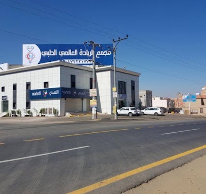
مجمع الريادة العالمي الطبي
طريق أبها، حي الدوحة، خميس مشيط
Hospital
read more
3.049 km
مركز الريادة الطبي للدكتور القصادي
Hospital
read more
3.387 km
Health center Abha Airport
3282, Abha
Hospital
read more
4.163 km
GNP
King Fahd Road, Khamis Mushait
Hospital
read more
4.357 km
الهلال الأحمر السعودي
5033, Abha
Hospital
read more
4.522 km
HOSPITAL
Saudi Arabia
Hospital
read more
4.909 km
معمل عبدالله للاسنان
Abha
Hospital
read more
5.18 km
مركز صحي عتود العماير
Unnamed Road, Aseer
Hospital
read more
5.43 km
مستشفى علاج
Khamis Mushait
Hospital
read more
5.481 km
مجمع الخميس الطبي
Imam Muhammad Ibn Saud, Khamis Mushait
Hospital
read more
5.492 km
Visions of the future dental compound
3063, Khamis Mushait
Hospital
read more
5.527 km
Crescent Hospital
8441, Khamis Mushait
Hospital
read more
5.6 km
Primary health care center district officers
Salah Addin, Khamis Mushait
Hospital
read more
5.605 km
مركز صحي حي الضباط
Unnamed Road, 62431, Khamis Mushait
Hospital
read more
5.633 km
مجمع اكليل الطب
حسام، خميس مشيط
Hospital
read more
5.641 km
مجمع اكليل الطب
Tariq Ibn Zyad, Khamis Mushait
Hospital
read more
5.687 km
مركز عبدالكريم شكري لطب الأسنان
Khamis Mushait
Hospital
read more
5.689 km
عيادات الدكتور عبد الكريم شكري للاسنان
Khamis Mushait
Hospital
read more
5.724 km
مركز طب الأسنان التخصصي
9355 صلاح الدين, Khamis Mushait
Hospital
read more
5.73 km
Alsafwa Dental Clinic
Khamis Mushait
Hospital
read more
5.751 km
Althemal
King Fahad Road، خميس مشيط
Hospital
read more
5.762 km
مجمع الصفوة لطب الاسنان
Khamis Mushait
Hospital
read more
📑
all categories
Accounting
Administrative area level 1
Airport
Amusement park
Aquarium
Art gallery
Atm
Bakery
Bank
Bar
Beauty salon
Bicycle store
Book store
Bowling alley
Bus station
Cafe
Campground
Car dealer
Car rental
Car repair
Car wash
Casino
Cemetery
Church
City hall
Clothing store
Colloquial area
Convenience store
Country
Courthouse
Dentist
Department store
Doctor
Electrician
Electronics store
Embassy
Finance
Fire station
Florist
Food
Funeral home
Furniture store
Gas station
General contractor
Grocery or supermarket
Gym
Hair care
Hardware store
Health
Hindu Temple
Home goods store
Hospital
Insurance agency
Intersection
Jewelry store
Laundry
Lawyer
Library
Light rail station
Liquor store
Local government office
Locality
Locksmith
Lodging
Meal delivery
Meal takeaway
Mosque
Movie rental
Movie theater
Moving company
Museum
Natural feature
Neighborhood
Night club
Painter
Park
Parking
Pet store
Pharmacy
Physiotherapist
Place of worship
Plumber
Point of interest
Police
Political
Post office
Premise
Real estate agency
Restaurant
Roofing contractor
Route
Rv park, camping
School
Shoe store
Shopping mall
Spa
Stadium
Storage
Store
Sublocality
Subpremise
Subway station
Supermarket
Taxi stand
Train station
Transit station
Travel agency
University
Veterinary care
Zoo
sublocality level 1
↑