Hospital nearby Al Mazarea Medical Center
Coronavirus disease (COVID-19) Situation
confirmed cases
841469
deaths
9646
Saudi Arabia
Hospital nearby Al Mazarea Medical Center
Al Mazarea Medical Center
King Faisal Road, 77455, Al Qurayyat Saudi Arabia
contacts phone
:
+966
Latitude:
31.32269
, Longitude:
37.36403
read more
nearest Hospital
452 m
مجمع العناد الطبي
Al Qurayyat
Hospital
read more
478 m
Health Center Hshehadh
Al Qurayyat
Hospital
read more
496 m
Al Hasida Medical Center
الشيخ محمد بن عبدالوهاب, 77455, Al Qurayyat
Hospital
read more
555 m
Health Center Hshehadh
ابن الارقم, Al Qurayyat
Hospital
read more
592 m
Al Qurayyat General Hospital
Ibn Sina, Al Qurayyat
Hospital
read more
851 m
التموين الطبي بالقريات
القريات
Hospital
read more
918 m
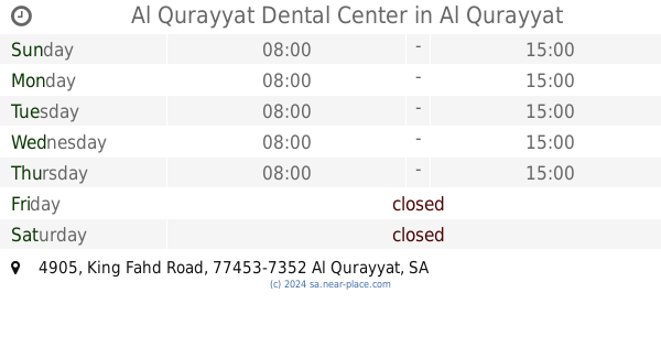
Al Qurayyat Dental Center
4905 King Fahd Road, Al Qurayyat
Hospital
read more
935 m
مركز غسيل الكلى
القريات
Hospital
read more
983 m
مركز طب الاسنان بالقريات
طريق الملك فهد، حصيدة،, Al Qurayyat
Hospital
read more
999 m
مجمع المدينة الطبي العام
Al Qurayyat
Hospital
read more
1.141 km
مركز الابتسامة المشرقة لطب الاسنان
القريات
Hospital
read more
1.271 km
مستوصف العزيزية القريات
الفروسية, Al Qurayyat
Hospital
read more
1.34 km
مركز صحي العزيزية
حارثة القبطية, Al Qurayyat
Hospital
read more
1.341 km
مركز صحي عين الحواس
Harithah Al Qibtiyyah, Al Qurayyat
Hospital
read more
1.941 km
مستوصف العزيزية
طريق المدينة المنورة،، القريات
Hospital
read more
1.947 km
عيادات مستوصف ابو طالب
Al Qurayyat
Hospital
read more
1.95 km
مستوصف ابو طالب
Al Qurayyat
Hospital
read more
1.969 km
مركز صحي حي المطار
Al Qurayyat
Hospital
read more
2.091 km
مستوصف جونيا الطبي
Al Qurayyat
Hospital
read more
2.119 km
مستوصف الوطني
Al Qurayyat
Hospital
read more
2.26 km
مركز صحي الرفاع
Umar Ibn Abdulaziz, Al Qurayyat
Hospital
read more
2.272 km
مجمع العجاج القريات
Tabuk, Al Qurayyat
Hospital
read more
2.298 km
Ghaith Pharmacy
Al Qurayyat
Hospital
read more
2.311 km
مجمع الدكتور سلطان الطبي
Al Qurayyat
Hospital
read more
2.355 km
المحكمه العامه بالقريات
Al Qurayyat
Hospital
read more
📑
all categories
Accounting
Administrative area level 1
Airport
Amusement park
Aquarium
Art gallery
Atm
Bakery
Bank
Bar
Beauty salon
Bicycle store
Book store
Bowling alley
Bus station
Cafe
Campground
Car dealer
Car rental
Car repair
Car wash
Casino
Cemetery
Church
City hall
Clothing store
Colloquial area
Convenience store
Country
Courthouse
Dentist
Department store
Doctor
Electrician
Electronics store
Embassy
Finance
Fire station
Florist
Food
Funeral home
Furniture store
Gas station
General contractor
Grocery or supermarket
Gym
Hair care
Hardware store
Health
Hindu Temple
Home goods store
Hospital
Insurance agency
Intersection
Jewelry store
Laundry
Lawyer
Library
Light rail station
Liquor store
Local government office
Locality
Locksmith
Lodging
Meal delivery
Meal takeaway
Mosque
Movie rental
Movie theater
Moving company
Museum
Natural feature
Neighborhood
Night club
Painter
Park
Parking
Pet store
Pharmacy
Physiotherapist
Place of worship
Plumber
Point of interest
Police
Political
Post office
Premise
Real estate agency
Restaurant
Roofing contractor
Route
Rv park, camping
School
Shoe store
Shopping mall
Spa
Stadium
Storage
Store
Sublocality
Subpremise
Subway station
Supermarket
Taxi stand
Train station
Transit station
Travel agency
University
Veterinary care
Zoo
sublocality level 1
↑