Hospital nearby عياده حي اليرموك 3 C3
Coronavirus disease (COVID-19) Situation
confirmed cases
841469
deaths
9646
Saudi Arabia
Hospital nearby عياده حي اليرموك 3 C3
عياده حي اليرموك 3 C3
Riyadh Saudi Arabia
contacts phone
:
+966
Latitude:
24.6773301
, Longitude:
46.8657605
read more
nearest Hospital
92 m
عيادة اليرموك 3
2982, Riyadh
Hospital
read more
556 m
مستشفى اليرموك بخشم العان
Riyadh
Hospital
read more
631 m
مستشفى اليرموك
3183, Riyadh
Hospital
read more
631 m
مستوصف اليرموك
3183, Riyadh
Hospital
read more
839 m
عياده الاسنان بحي حطين 3 D3
Riyadh
Hospital
read more
841 m
مستوصف طب الاسنان بالحرس الوطني
8351، 3795, Riyadh
Hospital
read more
847 m
عياده حي اليرموك 1 C1
Riyadh
Hospital
read more
847 m
عيادات حي حطين 1 D1
Riyadh
Hospital
read more
849 m
Hittin dental clinic
8329, Riyadh
Hospital
read more
876 m
مستوصف حطين ٣ ( D3 )
Riyadh
Hospital
read more
891 m
عياده حطين 1
7922،, 3649, Riyadh
Hospital
read more
917 m
عيادة الصحة المدرسية
Riyadh
Hospital
read more
924 m
عيادة حي اليرموك 1
Riyadh
Hospital
read more
1.514 km
A3 satellite clinic
7021, Riyadh
Hospital
read more
1.528 km
مستوصف حي احد(A3)
7021, 3285, Riyadh
Hospital
read more
1.532 km
مستوصف حي احد ٣ (A3)
Riyadh
Hospital
read more
1.546 km
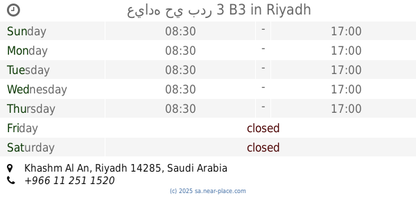
عياده حي بدر 3 B3
Riyadh
Hospital
read more
1.566 km
عياده حي حطين 2 D2
Riyadh
Hospital
read more
1.578 km
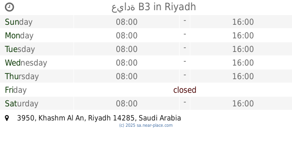
عيادة B3
3950, Riyadh
Hospital
read more
1.743 km
مستودع النظيم
8073 Shibh al Jazirah, Riyadh
Hospital
read more
1.836 km
عياده حي احد 2 A2
Riyadh
Hospital
read more
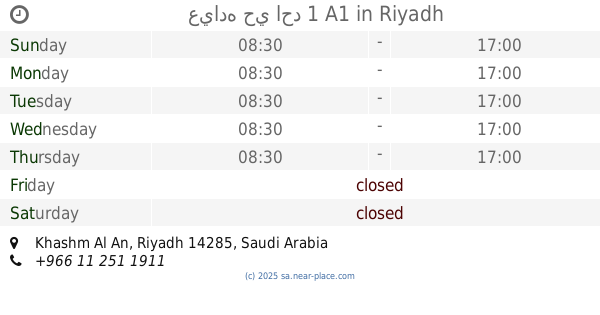
1.838 km
عياده حي احد 1 A1
Riyadh
Hospital
read more
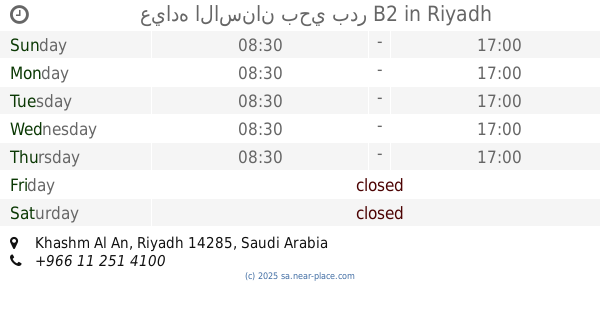
1.862 km
عياده الاسنان بحي بدر B2
Riyadh
Hospital
read more
1.876 km
مجمع النخيل الطبي
Jakarta, Riyadh
Hospital
read more
1.9 km
مستشفى أحد
2552, 6662, Riyadh
Hospital
read more
📑
all categories
Accounting
Administrative area level 1
Airport
Amusement park
Aquarium
Art gallery
Atm
Bakery
Bank
Bar
Beauty salon
Bicycle store
Book store
Bowling alley
Bus station
Cafe
Campground
Car dealer
Car rental
Car repair
Car wash
Casino
Cemetery
Church
City hall
Clothing store
Colloquial area
Convenience store
Country
Courthouse
Dentist
Department store
Doctor
Electrician
Electronics store
Embassy
Finance
Fire station
Florist
Food
Funeral home
Furniture store
Gas station
General contractor
Grocery or supermarket
Gym
Hair care
Hardware store
Health
Hindu Temple
Home goods store
Hospital
Insurance agency
Intersection
Jewelry store
Laundry
Lawyer
Library
Light rail station
Liquor store
Local government office
Locality
Locksmith
Lodging
Meal delivery
Meal takeaway
Mosque
Movie rental
Movie theater
Moving company
Museum
Natural feature
Neighborhood
Night club
Painter
Park
Parking
Pet store
Pharmacy
Physiotherapist
Place of worship
Plumber
Point of interest
Police
Political
Post office
Premise
Real estate agency
Restaurant
Roofing contractor
Route
Rv park, camping
School
Shoe store
Shopping mall
Spa
Stadium
Storage
Store
Sublocality
Subpremise
Subway station
Supermarket
Taxi stand
Train station
Transit station
Travel agency
University
Veterinary care
Zoo
sublocality level 1
↑