Laundry nearby مغاسل الخليج
Coronavirus disease (COVID-19) Situation
confirmed cases
841469
deaths
9646
Saudi Arabia
Laundry nearby مغاسل الخليج
مغاسل الخليج
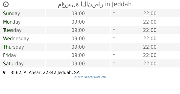
شارع بن لادن، حي الجامعة، جدة Saudi Arabia
contacts phone
:
+966
Latitude:
21.4692392
, Longitude:
39.2593079
read more
nearest Laundry
76 m
مغاسل السريعة
شارع بن لادن، حي الجامعة، جدة
Laundry
read more
252 m
مغاسل الحرمين
حي بلادن، جدة
Laundry
read more
343 m
مغاسل حصن
بن لادن، الروابي، جدة
Laundry
read more
350 m
مغسلة المدينة
بن لادن، الروابي، جدة
Laundry
read more
386 m
مغاسل ريان
شارع بن لادن، حي الروابي، جدة
Laundry
read more
422 m
مغاسل البشائر
بن لادن، الروابي، جدة
Laundry
read more
450 m
مغاسل سفاري السريعة
بن لادن ، الروابي، جدة
Laundry
read more
475 m
مغاسل الإزار المركزيه
3187, حي مدائن الفهد،, Jeddah
Laundry
read more
715 m
مغسلة الروابي
حي الروابي، جدة
Laundry
read more
730 m
مغاسل المتوكل بالله
5034 بلديه الاربعين, حي الروابي 7218, Jeddah
Laundry
read more
738 m
مكوجي الثرياء
طريق مكة القديم - كيلو 6، جدة
Laundry
read more
738 m
مغسلة الانصار
3562 Al Ansar, Jeddah
Laundry
read more
786 m
المغسلة الفرنسية للسيارات
3520 Hafsah Bint Umar, Jeddah
Laundry
read more
794 m
مغاسل السعودية
طريق مكة القديم ، كيلو ٦، جدة
Laundry
read more
879 m
مغاسل الرهدن
شارع عبد الله الأموي، حي الروابي، جدة
Laundry
read more
900 m
Revan laundry
290, Jeddah
Laundry
read more
942 m
مغاسل المستقبل
طريق مكة القديم - كيلو 6، جدة
Laundry
read more
946 m
مغاسل الشموخ للسيارات
عبدالله الأموي الفرعي, Jeddah
Laundry
read more
958 m
مغاسل السعودية
Unnamed Road, مدائن الفهد،, Jeddah
Laundry
read more
999 m
مغاسل الوادي
الجامعة، جدة
Laundry
read more
999 m
غسيل السيارات
8389 المائه، حي الروابي جدة 22348
Laundry
read more
1.042 km
مغسلة السواط للمفروشات
الجامعة، جدة
Laundry
read more
1.068 km
مغسلة بن عثمان
شارع الأمير متعب، بجوار أسواق الأمير متعب، كيلو 6، الجامعة، جدة
Laundry
read more
1.081 km
Algebra laundry
Abdullah Al Amawi Bransh Road, حي الروابي 5176, Jeddah
Laundry
read more
1.088 km
مغاسل سابا
3102 المائه الفرعي، حي الروابي، جدة 22348
Laundry
read more
📑
all categories
Accounting
Administrative area level 1
Airport
Amusement park
Aquarium
Art gallery
Atm
Bakery
Bank
Bar
Beauty salon
Bicycle store
Book store
Bowling alley
Bus station
Cafe
Campground
Car dealer
Car rental
Car repair
Car wash
Casino
Cemetery
Church
City hall
Clothing store
Colloquial area
Convenience store
Country
Courthouse
Dentist
Department store
Doctor
Electrician
Electronics store
Embassy
Finance
Fire station
Florist
Food
Funeral home
Furniture store
Gas station
General contractor
Grocery or supermarket
Gym
Hair care
Hardware store
Health
Hindu Temple
Home goods store
Hospital
Insurance agency
Intersection
Jewelry store
Laundry
Lawyer
Library
Light rail station
Liquor store
Local government office
Locality
Locksmith
Lodging
Meal delivery
Meal takeaway
Mosque
Movie rental
Movie theater
Moving company
Museum
Natural feature
Neighborhood
Night club
Painter
Park
Parking
Pet store
Pharmacy
Physiotherapist
Place of worship
Plumber
Point of interest
Police
Political
Post office
Premise
Real estate agency
Restaurant
Roofing contractor
Route
Rv park, camping
School
Shoe store
Shopping mall
Spa
Stadium
Storage
Store
Sublocality
Subpremise
Subway station
Supermarket
Taxi stand
Train station
Transit station
Travel agency
University
Veterinary care
Zoo
sublocality level 1
↑