Lodging nearby al hamra hotel
Saudi Arabia
Lodging nearby al hamra hotel
al hamra hotel
Al Futah, Riyadh 12632, Saudiarabien
contacts phone
:
+966
Latitude:
24.6404935
, Longitude:
46.7171794
larger map & directions
read more
nearest Lodging
21 m
قصر الحمراء وحدات سكنية مفروشة
7964 Al Batha, Riyadh
Lodging
read more
53 m
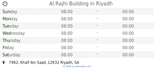
Al Rajhi Building
7962 Khalf Ibn Saad, Riyadh
Lodging
read more
81 m
Hotel Apollo Dimora
Khalf Ibn Saad, Riyadh
Lodging
read more
88 m
Aleairy
Al Batha, Riyadh
Lodging
read more
115 m
AL 'Oroba hotel
شارع البطحاء، منطقة البطحاء، الرياض
Lodging
read more
115 m
Ramada East Hotel
Khalf Ibn Saad, Riyadh
Lodging
read more
115 m
Ramada East Hotel
شارع خلف بن سعد، حي الفوطة، الرياض
Lodging
read more
132 m
Arouba Hotel
7297 Al Batha, Al Amal Riyadh 12643 2277 Al Batha, Riyadh
Lodging
read more
133 m
فندق العروبة - البطحاء
7297 Al Batha, Riyadh
Lodging
read more
151 m
Hotel Al Oruba
7297 Al Batha, Al Amal, Riyadh 12643 2277 Al Batha, Riyadh
Lodging
read more
158 m
Ghazi Hotel
AlGarabbi Street, Riyadh
Lodging
read more
186 m
اوركيديا الحمراء
7296 الغرابي, 2352, Riyadh
Lodging
read more
190 m
فندق أبا الخيل
7296 AlGarabbi Street, 2352, Riyadh
Lodging
read more
198 m
Salam Hotel
Al Farabi District , Al Batha Street, Riyadh
Lodging
read more
208 m
توليب ان
Al Batha, Riyadh
Lodging
read more
216 m
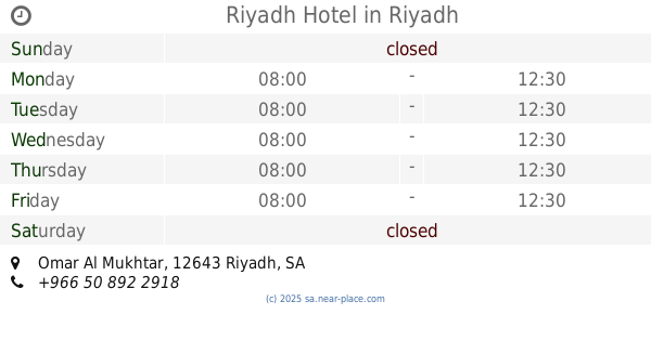
Riyadh Hotel
Omar Al Mukhtar, Riyadh
Lodging
read more
216 m
فندق اسيا
Unnamed Road, Riyadh
Lodging
read more
218 m
فندق آسيا
شارع اسد بن الفرات ، حي العمل، الرياض
Lodging
read more
222 m
ASIAN Hotel
2279 اسد بن الفرات, Riyadh
Lodging
read more
226 m
فندق أوركيدا الحمراء البطحاء
Riyadh
Lodging
read more
228 m
Abal Khail Hotel
حى العمل شارع الغرابي, Riyadh
Lodging
read more
229 m
Dorrat Alaqsa hotel فندق درة الأقصى
Al Batha, Riyadh
Lodging
read more
252 m
Victory Hotel
3511 الامام فيصل بن تركي بن عبدالله، الديرة الرياض 12633 7674 Al Imam Faisal Ibn Turki Ibn Abdullah, Riyadh
Lodging
read more
254 m
فندق المدائن
شارع الامير فيصل بن تركي، الرياض
Lodging
read more
279 m
Al Darah Hòtel
2282 اسد بن الفرات, Riyadh
Lodging
read more
📑
all categories
Accounting
Administrative area level 1
Airport
Amusement park
Aquarium
Art gallery
Atm
Bakery
Bank
Bar
Beauty salon
Bicycle store
Book store
Bowling alley
Bus station
Cafe
Campground
Car dealer
Car rental
Car repair
Car wash
Casino
Cemetery
Church
City hall
Clothing store
Colloquial area
Convenience store
Country
Courthouse
Dentist
Department store
Doctor
Electrician
Electronics store
Embassy
Finance
Fire station
Florist
Food
Funeral home
Furniture store
Gas station
General contractor
Grocery or supermarket
Gym
Hair care
Hardware store
Health
Hindu Temple
Home goods store
Hospital
Insurance agency
Intersection
Jewelry store
Laundry
Lawyer
Library
Light rail station
Liquor store
Local government office
Locality
Locksmith
Lodging
Meal delivery
Meal takeaway
Mosque
Movie rental
Movie theater
Moving company
Museum
Natural feature
Neighborhood
Night club
Painter
Park
Parking
Pet store
Pharmacy
Physiotherapist
Place of worship
Plumber
Point of interest
Police
Political
Post office
Premise
Real estate agency
Restaurant
Roofing contractor
Route
Rv park, camping
School
Shoe store
Shopping mall
Spa
Stadium
Storage
Store
Sublocality
Subpremise
Subway station
Supermarket
Taxi stand
Train station
Transit station
Travel agency
University
Veterinary care
Zoo
sublocality level 1
↑