Lodging nearby Apartments Nov 12
Coronavirus disease (COVID-19) Situation
confirmed cases
841469
deaths
9646
Saudi Arabia
Lodging nearby Apartments Nov 12
Apartments Nov 12
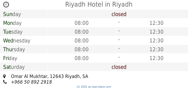
ابي أيوب الأنصاري, Abu Ayyub Al-Ansari, 12645, Riyadh, SA Saudi Arabia
contacts phone
:
+966 11 413 4565
Latitude:
24.6383268
, Longitude:
46.7237363
larger map & directions
read more
nearest Lodging
174 m
Al Nahda Hotel
شارع أبي ايوب الأنصاري، البطحاء، الرياض
Lodging
read more
187 m
Hotel Najza فندق النهزة
2697 Abu Ayyub Al-Ansari, 6902, Riyadh
Lodging
read more
207 m
شقاق البطحاء
6718 جرجاء،، الرياض
Lodging
read more
209 m
بيت العزابه
2975 البدر النابلسي، ثليم، الرياض 12645
Lodging
read more
239 m
شقق التعاون المفروشة
شارع ابى ايوب الانصارى، الرياض
Lodging
read more
254 m
مكتب السويد للعقارات
Al Farazdaq Road Al Farazdaq Road, Riyadh
Lodging
read more
266 m
Nof 12 Aparthotel, Souq Al Thumairi,
Riyadh
Lodging
read more
373 m
منازل الحمد
Mecca
Lodging
read more
415 m
الجمعية
Unnamed Road, Riyadh
Lodging
read more
435 m
Asemah Hotel
Umar Al Mukhtar Street, Riyadh
Lodging
read more
456 m
Capital Hotel. Batha
Riyadh
Lodging
read more
460 m
فندق العاصمة/شارع الريل
Omar Al Mukhtar, Riyadh
Lodging
read more
460 m
فندق العاصمة
Omar Al Mukhtar, Riyadh
Lodging
read more
530 m
فندق القاهرة
Abu Ayyub Al-Ansari, Riyadh
Lodging
read more
547 m
Ghazi Hotel
AlGarabbi Street, Riyadh
Lodging
read more
556 m
حلا للشقق المفروشة
ثابت بن النعمان Thanit Ibn An Numan, Riyadh
Lodging
read more
558 m
Riyadh Hotel
Omar Al Mukhtar, Riyadh
Lodging
read more
562 m
جمعية شبتوت قبلي
المحارب، ثليم،, Riyadh
Lodging
read more
580 m
فندق أوركيدا الحمراء البطحاء
Riyadh
Lodging
read more
602 m
فندق التاج الجديد
Riyadh
Lodging
read more
614 m
Dorrat Alaqsa hotel فندق درة الأقصى
Al Batha, Riyadh
Lodging
read more
632 m
Aleairy
Al Batha, Riyadh
Lodging
read more
634 m
اوركيديا الحمراء
7296 الغرابي, 2352, Riyadh
Lodging
read more
652 m
فندق أبا الخيل
7296 AlGarabbi Street, 2352, Riyadh
Lodging
read more
657 m
فندق المدائن
شارع الامير فيصل بن تركي، الرياض
Lodging
read more
📑
all categories
Accounting
Administrative area level 1
Airport
Amusement park
Aquarium
Art gallery
Atm
Bakery
Bank
Bar
Beauty salon
Bicycle store
Book store
Bowling alley
Bus station
Cafe
Campground
Car dealer
Car rental
Car repair
Car wash
Casino
Cemetery
Church
City hall
Clothing store
Colloquial area
Convenience store
Country
Courthouse
Dentist
Department store
Doctor
Electrician
Electronics store
Embassy
Finance
Fire station
Florist
Food
Funeral home
Furniture store
Gas station
General contractor
Grocery or supermarket
Gym
Hair care
Hardware store
Health
Hindu Temple
Home goods store
Hospital
Insurance agency
Intersection
Jewelry store
Laundry
Lawyer
Library
Light rail station
Liquor store
Local government office
Locality
Locksmith
Lodging
Meal delivery
Meal takeaway
Mosque
Movie rental
Movie theater
Moving company
Museum
Natural feature
Neighborhood
Night club
Painter
Park
Parking
Pet store
Pharmacy
Physiotherapist
Place of worship
Plumber
Point of interest
Police
Political
Post office
Premise
Real estate agency
Restaurant
Roofing contractor
Route
Rv park, camping
School
Shoe store
Shopping mall
Spa
Stadium
Storage
Store
Sublocality
Subpremise
Subway station
Supermarket
Taxi stand
Train station
Transit station
Travel agency
University
Veterinary care
Zoo
sublocality level 1
↑