Lodging nearby Farm Arish
Saudi Arabia
Lodging nearby Farm Arish
Farm Arish
3320, Saihat 32463, Saudi Arabia
contacts phone
:
+966 59 839 9513
Latitude:
26.5017235
, Longitude:
50.0206363
larger map & directions
read more
nearest Lodging
81 m
Al Mohsen Farm مزرعه المحسن
3293, Saihat
Lodging
read more
241 m
Amazon resort
Sahel Ibn Haneef St, Saihat
Lodging
read more
299 m
مزرعة ال محمدعلي
Saihat
Lodging
read more
300 m
مزرعة ال محمدعلي بسيهات
Saihat
Lodging
read more
399 m
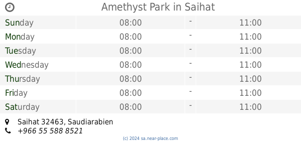
Amethyst Park
Saihat
Lodging
read more
488 m
استراحة الجودي
Sahel Ibn Haneef Street, Saihat
Lodging
read more
673 m
منتجع قلعة سيهات
شارع الملك عبد العزيز...خلف مصنع طابوق, Dammam
Lodging
read more
694 m
منتجع كليبترا
Saihat
Lodging
read more
825 m
منتجع قلعة سيهات
4016, 6633, Saihat
Lodging
read more
1.052 km
Antik Resort
4906, Anak
Lodging
read more
1.16 km
منتجع السمين
طريق سيهات القطيف، القطيف
Lodging
read more
1.222 km
مزرعة المنيان
Anak
Lodging
read more
1.289 km
مزرعة ناصر يوسف المحمد علي
Anak
Lodging
read more
1.361 km
Al Amani Resort
4145, Anak
Lodging
read more
1.426 km
Dilmun Resort
Saihat
Lodging
read more
1.463 km
Alzuhor Resort || مزرعة الزهور
4425, Saihat
Lodging
read more
1.523 km
منتجع الأمين Alamin Resort
Makkah Street, Saihat
Lodging
read more
1.704 km
منتجع زيلامسي
3123, Saihat
Lodging
read more
1.716 km
جبل القرين
3902, 8143, Saihat
Lodging
read more
1.725 km
Aroos Bahrain Resort
طريق الدمام السريع,Saihat، الجبيل
Lodging
read more
1.725 km
Bahrain Bride Resort
طريق الدمام السريع,Saihat، الجبيل
Lodging
read more
1.74 km
مزرعة و منتجع صدارة
Saihat
Lodging
read more
1.741 km
استراحة الديرة بالجش
Saihat
Lodging
read more
1.775 km
منتجع جنى السياحي
Unnamed Road،, Saihat
Lodging
read more
1.903 km
Shandiz Resort
Saihat
Lodging
read more
📑
all categories
Accounting
Administrative area level 1
Airport
Amusement park
Aquarium
Art gallery
Atm
Bakery
Bank
Bar
Beauty salon
Bicycle store
Book store
Bowling alley
Bus station
Cafe
Campground
Car dealer
Car rental
Car repair
Car wash
Casino
Cemetery
Church
City hall
Clothing store
Colloquial area
Convenience store
Country
Courthouse
Dentist
Department store
Doctor
Electrician
Electronics store
Embassy
Finance
Fire station
Florist
Food
Funeral home
Furniture store
Gas station
General contractor
Grocery or supermarket
Gym
Hair care
Hardware store
Health
Hindu Temple
Home goods store
Hospital
Insurance agency
Intersection
Jewelry store
Laundry
Lawyer
Library
Light rail station
Liquor store
Local government office
Locality
Locksmith
Lodging
Meal delivery
Meal takeaway
Mosque
Movie rental
Movie theater
Moving company
Museum
Natural feature
Neighborhood
Night club
Painter
Park
Parking
Pet store
Pharmacy
Physiotherapist
Place of worship
Plumber
Point of interest
Police
Political
Post office
Premise
Real estate agency
Restaurant
Roofing contractor
Route
Rv park, camping
School
Shoe store
Shopping mall
Spa
Stadium
Storage
Store
Sublocality
Subpremise
Subway station
Supermarket
Taxi stand
Train station
Transit station
Travel agency
University
Veterinary care
Zoo
sublocality level 1
↑