Lodging nearby yuksel Residential Building
Saudi Arabia
Lodging nearby yuksel Residential Building
yuksel Residential Building
6722، المونسية، الرياض 13249 Saudi Arabia
contacts phone
:
+966
Latitude:
24.8306295
, Longitude:
46.762028
read more
nearest Lodging
124 m
Spray a break
Prince Saud Bin Mohammed Bin Muqrin Road, Riyadh
Lodging
read more
331 m
إستراحة الريّس
6950, 4190, Riyadh
Lodging
read more
449 m
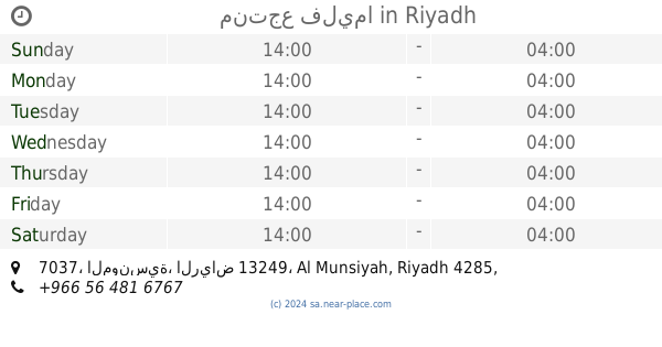
منتجع فليما
7037، المونسية، الرياض 13249
Lodging
read more
459 m
استراحة الزميع
7037, 4285, Riyadh
Lodging
read more
590 m
منتجع ترف
8400 Al Sahaba Road, Riyadh
Lodging
read more
629 m
Accommodation Munshiya
Riyadh
Lodging
read more
645 m
شاليهات ترف الرياض
2835, Riyadh
Lodging
read more
649 m
Al Malqa Aparthotel Riyadh
طريق الصحابة, شارع الدمام, منطقة منسية, Riyadh
Lodging
read more
685 m
فيلا محمدابوبكر
الرياض
Lodging
read more
766 m
استراحة السوالف
3874, Riyadh
Lodging
read more
778 m
Resorts
No. 80, Riyadh
Lodging
read more
815 m
علم الفريدة للوحدات السكنية المفروشة
Riyadh
Lodging
read more
829 m
إستراحة عويس الأطرم
2599, Riyadh
Lodging
read more
884 m
Chalet conscience
شارع رقم 423, Riyadh
Lodging
read more
893 m
استراحه التوت
2278, 7436, Riyadh
Lodging
read more
898 m
Semo Alanwan 2
Al Rasheed St., Riyadh
Lodging
read more
904 m
فندق سمو العنوان
Riyadh
Lodging
read more
1.128 km
عمارة دلتا السكنية عزاب بحي المونسية
Riyadh
Lodging
read more
1.258 km
شاليهات توب تن
7599, Riyadh
Lodging
read more
1.284 km
شقة ناصر
شارع التنعيم،، الرياض
Lodging
read more
1.296 km
Sahaba Road East Side
Riyadh
Lodging
read more
1.298 km
للعزاب
شارع البيضاء- حي المونسية، الرياض
Lodging
read more
1.312 km
شاليهات النور
الرياض
Lodging
read more
1.332 km
استراحة الصفصاف
3106, Riyadh
Lodging
read more
1.343 km
Asiri Home
الرياض
Lodging
read more
📑
all categories
Accounting
Administrative area level 1
Airport
Amusement park
Aquarium
Art gallery
Atm
Bakery
Bank
Bar
Beauty salon
Bicycle store
Book store
Bowling alley
Bus station
Cafe
Campground
Car dealer
Car rental
Car repair
Car wash
Casino
Cemetery
Church
City hall
Clothing store
Colloquial area
Convenience store
Country
Courthouse
Dentist
Department store
Doctor
Electrician
Electronics store
Embassy
Finance
Fire station
Florist
Food
Funeral home
Furniture store
Gas station
General contractor
Grocery or supermarket
Gym
Hair care
Hardware store
Health
Hindu Temple
Home goods store
Hospital
Insurance agency
Intersection
Jewelry store
Laundry
Lawyer
Library
Light rail station
Liquor store
Local government office
Locality
Locksmith
Lodging
Meal delivery
Meal takeaway
Mosque
Movie rental
Movie theater
Moving company
Museum
Natural feature
Neighborhood
Night club
Painter
Park
Parking
Pet store
Pharmacy
Physiotherapist
Place of worship
Plumber
Point of interest
Police
Political
Post office
Premise
Real estate agency
Restaurant
Roofing contractor
Route
Rv park, camping
School
Shoe store
Shopping mall
Spa
Stadium
Storage
Store
Sublocality
Subpremise
Subway station
Supermarket
Taxi stand
Train station
Transit station
Travel agency
University
Veterinary care
Zoo
sublocality level 1
↑