Mosque nearby Almsaeidih mosque
Saudi Arabia
Mosque nearby Almsaeidih mosque
Almsaeidih mosque
Salih At Tunsi, 23324, Jeddah, SA Saudi Arabia
contacts phone
:
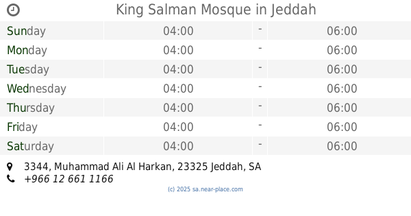
+966 12 620 5566
website:
www.jeddah.gov.sa
Latitude:
21.5389362
, Longitude:
39.1758192
larger map & directions
read more
nearest Mosque
332 m
مسجد مستشفى النساء والولادة بالمساعدية
جدة
Mosque
read more
383 m
King Khalid Mosque
Mishrifah
Mosque
read more
396 m
مسجد جلالة الملك خالد بن عبدالعزيز آل سعود
2556 Al-Madinah Al-Munawarah Road, حي مشرفة،, Jeddah
Mosque
read more
512 m
Masjid
First floor Near CAT shop, Al Madinah Al Munawara Road , Musadia, Jeddah
Mosque
read more
523 m
مسجد علي الجارم
شارع الفضل، حي الحمراء، جدة
Mosque
read more
571 m
مسجد العمودي
2651 الزهره، حي مشرفة، جدة 23332 6690 Az Zahrah, Jeddah
Mosque
read more
804 m
Mandoora Mosque
Shat Al Arab, Jeddah
Mosque
read more
809 m
Alsalam Mosque
Saeed Ibn Zaqr, Jeddah
Mosque
read more
871 m
مسجد الأميرة طرفة
2477 Saeed Ibn Zaqr, Jeddah
Mosque
read more
883 m
مسجد الصانبي
3074 Al Mizan, Mishrifah District, Jeddah
Mosque
read more
957 m
مسجد الحق
Jeddah
Mosque
read more
986 m
King Salman Mosque
3344 Muhammad Ali Al Harkan, Jeddah
Mosque
read more
1.071 km
مسجد العنقري
Jeddah
Mosque
read more
1.076 km
مسجد الشؤون
6740 حسين الشبكشي، حي الحمراء، جدة 23324
Mosque
read more
1.084 km
Mosque
Al Andalus
Mosque
read more
1.094 km
Abdullah bin Ammar Mosque
Arafat, Jeddah
Mosque
read more
1.103 km
Masjid AL Adel
Al Hawwat, Jeddah
Mosque
read more
1.149 km
مسجد المطلق
3718 Al Hikmah, Al Hamra District,, Jeddah
Mosque
read more
1.179 km
Prince Turki bin Khalid Mosque
Alqndeel, Jeddah
Mosque
read more
1.215 km
مسجد الرحمن
حي مشرفة، جدة
Mosque
read more
1.215 km
مسجد الرحمن
شارع محمد الطويل، حي مشرفة، جدة
Mosque
read more
1.215 km
Alrahman Mosque
Mishrifah
Mosque
read more
1.262 km
Rahma mosque believers
Hasan Yahya, Jeddah
Mosque
read more
1.28 km
Good Yasser Mosque
An Nujum, Jeddah
Mosque
read more
1.308 km
مسجد سيد الشهداء
Mishrifah
Mosque
read more
📑
all categories
Accounting
Administrative area level 1
Airport
Amusement park
Aquarium
Art gallery
Atm
Bakery
Bank
Bar
Beauty salon
Bicycle store
Book store
Bowling alley
Bus station
Cafe
Campground
Car dealer
Car rental
Car repair
Car wash
Casino
Cemetery
Church
City hall
Clothing store
Colloquial area
Convenience store
Country
Courthouse
Dentist
Department store
Doctor
Electrician
Electronics store
Embassy
Finance
Fire station
Florist
Food
Funeral home
Furniture store
Gas station
General contractor
Grocery or supermarket
Gym
Hair care
Hardware store
Health
Hindu Temple
Home goods store
Hospital
Insurance agency
Intersection
Jewelry store
Laundry
Lawyer
Library
Light rail station
Liquor store
Local government office
Locality
Locksmith
Lodging
Meal delivery
Meal takeaway
Mosque
Movie rental
Movie theater
Moving company
Museum
Natural feature
Neighborhood
Night club
Painter
Park
Parking
Pet store
Pharmacy
Physiotherapist
Place of worship
Plumber
Point of interest
Police
Political
Post office
Premise
Real estate agency
Restaurant
Roofing contractor
Route
Rv park, camping
School
Shoe store
Shopping mall
Spa
Stadium
Storage
Store
Sublocality
Subpremise
Subway station
Supermarket
Taxi stand
Train station
Transit station
Travel agency
University
Veterinary care
Zoo
sublocality level 1
↑