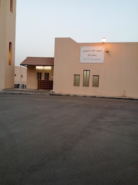
Mosque nearby جامع الحبيش
Saudi Arabia
Mosque nearby جامع الحبيش
جامع الحبيش
No.4, 14261, Riyadh, SA Saudi Arabia
contacts phone
:
+966
Latitude:
24.6620578
, Longitude:
46.7947814
larger map & directions
read more
nearest Mosque
267 m
مسجد عائشة بنت أبي بكر
3082, Riyadh
Mosque
read more
293 m
مسجد الشيخ محمد ناصر الدين الألباني
Riyadh
Mosque
read more
440 m
مسجد أبي بكر الصديق رضي الله عنه
Al Jazirah, Riyadh
Mosque
read more
490 m
مسجد علي بن أبي طالب - Mosque Ali bin Abi Talib
7697 No.12, Riyadh
Mosque
read more
540 m
مسجد الإمام الذهبي
Al Jazirah
Mosque
read more
542 m
مسجد البهلال
Al Jazirah
Mosque
read more
542 m
مسجد البهلال
Riyadh
Mosque
read more
544 m
Zubair bin Awam Mosque
2944, Riyadh
Mosque
read more
559 m
Abu Obaida Mosque
رقم 2, Riyadh
Mosque
read more
670 m
جامع سوق شرق East Market Mosque
Riyadh
Mosque
read more
735 m
El Hadji Mosque
No.14, Riyadh
Mosque
read more
900 m
دار الذكر مقابل جامع التوحيد في الشارع الخامس بحي الجزيرة بالرياض
شارع الخامس, Riyadh
Mosque
read more
905 m
Al-Tawheed Mosque
4th, Riyadh
Mosque
read more
939 m
Saad Bin Abi Waqqas Mosque
Abu Ubaydah Amir Ibn al Jarrah, Riyadh
Mosque
read more
1.021 km
Ahmad ibn Hanbal Mosque
3958, 8333, Riyadh
Mosque
read more
1.061 km
مسجد المركز الاداري
Eastern Ring Branch Road, Riyadh
Mosque
read more
1.089 km
Mus‘ab ibn 'Umair Mosque
Riyadh
Mosque
read more
1.092 km
Aqeel Al-Rajhi
Riyadh
Mosque
read more
1.17 km
Mosque of Ibn Baz
Riyadh
Mosque
read more
1.217 km
Imam Bukhari Mosque
6655 رقم 16, 3478, Riyadh
Mosque
read more
1.219 km
مسجد
Al Jazirah
Mosque
read more
1.224 km
مسجد أبو بكر الصديق رضي الله عنه
شارع 5, Riyadh
Mosque
read more
1.232 km
مسجد
Al Jazirah, Riyadh
Mosque
read more
1.291 km
مسجد ابن عثيمين ibn al Uthaymeen Mosque
4335 Number 1, 8098, Riyadh
Mosque
read more
1.379 km
Masjid Naeem Ibn Masood (R)
Riyadh
Mosque
read more
📑
all categories
Accounting
Administrative area level 1
Airport
Amusement park
Aquarium
Art gallery
Atm
Bakery
Bank
Bar
Beauty salon
Bicycle store
Book store
Bowling alley
Bus station
Cafe
Campground
Car dealer
Car rental
Car repair
Car wash
Casino
Cemetery
Church
City hall
Clothing store
Colloquial area
Convenience store
Country
Courthouse
Dentist
Department store
Doctor
Electrician
Electronics store
Embassy
Finance
Fire station
Florist
Food
Funeral home
Furniture store
Gas station
General contractor
Grocery or supermarket
Gym
Hair care
Hardware store
Health
Hindu Temple
Home goods store
Hospital
Insurance agency
Intersection
Jewelry store
Laundry
Lawyer
Library
Light rail station
Liquor store
Local government office
Locality
Locksmith
Lodging
Meal delivery
Meal takeaway
Mosque
Movie rental
Movie theater
Moving company
Museum
Natural feature
Neighborhood
Night club
Painter
Park
Parking
Pet store
Pharmacy
Physiotherapist
Place of worship
Plumber
Point of interest
Police
Political
Post office
Premise
Real estate agency
Restaurant
Roofing contractor
Route
Rv park, camping
School
Shoe store
Shopping mall
Spa
Stadium
Storage
Store
Sublocality
Subpremise
Subway station
Supermarket
Taxi stand
Train station
Transit station
Travel agency
University
Veterinary care
Zoo
sublocality level 1
↑