Mosque nearby مسجد ابي ذرالغفاري
Saudi Arabia
Mosque nearby مسجد ابي ذرالغفاري
مسجد ابي ذرالغفاري
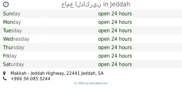
4329 سرية عبدالله بن حذافة، حي السامر، جدة 23462 7153, سرية عبدالله بن حذافة, 23462, Jeddah, SA Saudi Arabia
contacts phone
:
+966
Latitude:
21.5930893
, Longitude:
39.2437203
larger map & directions
read more
nearest Mosque
17 m
مسجد أبي ذر الغفاري
Al-Samer
Mosque
read more
240 m
Al Muhajirin Mosque
Al-Samer
Mosque
read more
251 m
مسجد المهاجرين الجامع
شارع أم الدرداء الكبرى, Jeddah
Mosque
read more
391 m
Furqan Mosque
7546 عبدالله ال مفلح, حي المنار, Jeddah
Mosque
read more
501 m
مصلى
رباح بن أبي معروف, Jeddah
Mosque
read more
550 m
Rahman mosque
Jeddah
Mosque
read more
556 m
مسجد الصابرين
Muhammed Bin Abbad Street, Jeddah
Mosque
read more
662 m
مسجد الهدى
الحوية, Jeddah
Mosque
read more
702 m
مسجد عبدالله ناس
Jeddah
Mosque
read more
730 m
مسجد طلحة بن عبيدالله
Al-Samer
Mosque
read more
754 m
مسجد محطة الأماكن
جدة
Mosque
read more
837 m
مسجد الذاكرين
Al Ajwad
Mosque
read more
853 m
جامع الذاكرين
Makkah - Jeddah Highway, حي الأجواد, Jeddah
Mosque
read more
942 m
مسجد البغدادي
Al-Samer
Mosque
read more
951 m
مسجد البغدادي
عبدالرحمن روزي،، جدة
Mosque
read more
952 m
جامع البغدادي
شارع عبد الرحمن روزي، حي السامر، جدة
Mosque
read more
971 m
مسجد العسالي
Mouawiyah Al Sulami, Jeddah
Mosque
read more
971 m
مسجد عبدالمحسن دخيل الله المرواني
Mouawiyah Al Sulami, Jeddah
Mosque
read more
973 m
مسجد
Mouawiyah Al Sulami, Jeddah
Mosque
read more
981 m
مسجد البنيان
Al-Manar
Mosque
read more
985 m
مسجد تلمنس
Jeddah
Mosque
read more
1.013 km
Alqahtani Mosque
3344 المحب الطبري, حي السامر،, Jeddah
Mosque
read more
1.013 km
Izz ibn Abd al-Salam Mosque
جعفر بن ربيعة, Jeddah
Mosque
read more
1.041 km
مسجد الألفه
8167 شمس الدين الاستجي, Al Manar District, Jeddah
Mosque
read more
1.043 km
مصلى العيد
Al-Manar
Mosque
read more
📑
all categories
Accounting
Administrative area level 1
Airport
Amusement park
Aquarium
Art gallery
Atm
Bakery
Bank
Bar
Beauty salon
Bicycle store
Book store
Bowling alley
Bus station
Cafe
Campground
Car dealer
Car rental
Car repair
Car wash
Casino
Cemetery
Church
City hall
Clothing store
Colloquial area
Convenience store
Country
Courthouse
Dentist
Department store
Doctor
Electrician
Electronics store
Embassy
Finance
Fire station
Florist
Food
Funeral home
Furniture store
Gas station
General contractor
Grocery or supermarket
Gym
Hair care
Hardware store
Health
Hindu Temple
Home goods store
Hospital
Insurance agency
Intersection
Jewelry store
Laundry
Lawyer
Library
Light rail station
Liquor store
Local government office
Locality
Locksmith
Lodging
Meal delivery
Meal takeaway
Mosque
Movie rental
Movie theater
Moving company
Museum
Natural feature
Neighborhood
Night club
Painter
Park
Parking
Pet store
Pharmacy
Physiotherapist
Place of worship
Plumber
Point of interest
Police
Political
Post office
Premise
Real estate agency
Restaurant
Roofing contractor
Route
Rv park, camping
School
Shoe store
Shopping mall
Spa
Stadium
Storage
Store
Sublocality
Subpremise
Subway station
Supermarket
Taxi stand
Train station
Transit station
Travel agency
University
Veterinary care
Zoo
sublocality level 1
↑