Mosque nearby مسجد موضي عبدالكريم الخياط وابنها احمد رحمهما الله
Saudi Arabia
Mosque nearby مسجد موضي عبدالكريم الخياط وابنها احمد رحمهما الله
مسجد موضي عبدالكريم الخياط وابنها احمد رحمهما الله
Riyadh Saudi Arabia
contacts phone
:
+966
Latitude:
24.876469
, Longitude:
46.6332148
read more
nearest Mosque
554 m
مسجد نور الصالحين
الرياض
Mosque
read more
593 m
Abdullah Alaqel and his Parents Mosque
Riyadh
Mosque
read more
643 m
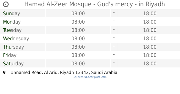
Hamad Al-Zeer Mosque - God's mercy -
Unnamed Road, Riyadh
Mosque
read more
695 m
Sheikh Hamad bin Nasser Al-Zeer Mosque
Riyadh
Mosque
read more
745 m
جامع منيرة بنت سعد الحليبة ووالديها
Riyadh
Mosque
read more
745 m
Collector Ahaliah
Unnamed Road, Riyadh
Mosque
read more
802 m
Masharef Hills Mosque
Riyadh
Mosque
read more
882 m
مسجد لطيفه بنت جاسر الماضي وابنها الشيخ محمد اللعبون
Riyadh
Mosque
read more
883 m
مسجد لطيفة ماضي الجاسر
Riyadh
Mosque
read more
889 m
Sheikh Ali AlMarshad Mosque
Riyadh
Mosque
read more
889 m
جامع الشيخ علي بن مرشد المرشد
Riyadh
Mosque
read more
981 m
مسجد هيا البهيشان
Riyadh
Mosque
read more
1.096 km
مسجد عبدالله
Riyadh
Mosque
read more
1.107 km
جامع سعد بن سعود ال تويم
Riyadh
Mosque
read more
1.129 km
مسجد العضيب
Riyadh
Mosque
read more
1.283 km
مسجد أحمد الراجحي
Riyadh
Mosque
read more
1.359 km
مسجد الجوهرة المقرن
Riyadh
Mosque
read more
1.393 km
مسجد الصديق
Riyadh
Mosque
read more
1.447 km
مسجد
Al Arid, Riyadh
Mosque
read more
1.447 km
مسجد
Al Aarid, Riyadh
Mosque
read more
1.458 km
Masjed Mohammad Alawad
Riyadh
Mosque
read more
1.458 km
مسجد والدي محمد عبداللطيف العواد ووالديهما رحمهم الله
Riyadh
Mosque
read more
1.594 km
Parents Mosque
Abi Bakr As Siddiq Road, Riyadh
Mosque
read more
1.618 km
Abu Obaida Mosque
Al Qasar Street, Riyadh
Mosque
read more
1.699 km
جامع الوالدين طرق الملك عبزالعزيز
الرياض
Mosque
read more
📑
all categories
Accounting
Administrative area level 1
Airport
Amusement park
Aquarium
Art gallery
Atm
Bakery
Bank
Bar
Beauty salon
Bicycle store
Book store
Bowling alley
Bus station
Cafe
Campground
Car dealer
Car rental
Car repair
Car wash
Casino
Cemetery
Church
City hall
Clothing store
Colloquial area
Convenience store
Country
Courthouse
Dentist
Department store
Doctor
Electrician
Electronics store
Embassy
Finance
Fire station
Florist
Food
Funeral home
Furniture store
Gas station
General contractor
Grocery or supermarket
Gym
Hair care
Hardware store
Health
Hindu Temple
Home goods store
Hospital
Insurance agency
Intersection
Jewelry store
Laundry
Lawyer
Library
Light rail station
Liquor store
Local government office
Locality
Locksmith
Lodging
Meal delivery
Meal takeaway
Mosque
Movie rental
Movie theater
Moving company
Museum
Natural feature
Neighborhood
Night club
Painter
Park
Parking
Pet store
Pharmacy
Physiotherapist
Place of worship
Plumber
Point of interest
Police
Political
Post office
Premise
Real estate agency
Restaurant
Roofing contractor
Route
Rv park, camping
School
Shoe store
Shopping mall
Spa
Stadium
Storage
Store
Sublocality
Subpremise
Subway station
Supermarket
Taxi stand
Train station
Transit station
Travel agency
University
Veterinary care
Zoo
sublocality level 1
↑