Mosque nearby مصلى العيد
Saudi Arabia
Mosque nearby مصلى العيد
مصلى العيد
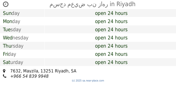
Al Muqdah, 13251, Riyadh, SA Saudi Arabia
contacts phone
:
+966
Latitude:
24.8049283
, Longitude:
46.7878532
larger map & directions
read more
nearest Mosque
95 m
Malihi Mosque
Al Maysimyah, Riyadh
Mosque
read more
97 m
Mosque for the Eid prayer
الميسمية Al Maysimyah, Riyadh
Mosque
read more
311 m
مسجد سعد بن شريد السبيعي
6373 Al Misroh, Riyadh
Mosque
read more
529 m
جامع ابن عثيمين
2687 Imam Abdullah Ibn Saud Ibn Abdulaziz Road, Riyadh
Mosque
read more
636 m
Nasser Bin Saidan mosque
Riyadh
Mosque
read more
682 m
مسجد
2645 Abi Jafar Al Mansur, Riyadh
Mosque
read more
740 m
Malihi Mosque
Al Hathli, Riyadh
Mosque
read more
796 m
Abu Ubaidah ibn al-Jarrah mosque
6797 النويبع، اليرموك، الرياض 13251 4010 An Nauwaibi, Riyadh
Mosque
read more
813 m
مسجد
Saad Ibn Muthayb Saad Ibn Muthayb, Riyadh
Mosque
read more
815 m
مسجد الفاروق
2227 Al Ghazwa, Riyadh
Mosque
read more
854 m
مسجد أم عبدالرحمن
3540 Al Mawsim, Riyadh
Mosque
read more
915 m
Osama bin Zaid mosque
Al Murid, Riyadh
Mosque
read more
915 m
Drees Ibrahim Mosque
Riyadh
Mosque
read more
943 m
Al-Mashrafy Mosque
3426 Masalah, Riyadh
Mosque
read more
958 m
Mosqu
Riyadh
Mosque
read more
985 m
مسجد
3544شارع الباقرة ، اليرموك, Riyadh
Mosque
read more
992 m
مسجد معيض بن زاهر
7632 Mayzila, Riyadh
Mosque
read more
1.008 km
جامع الأمير خالد بن مساعد
7311 الثريا, Riyadh
Mosque
read more
1.045 km
مسجد المحسن الصالح Mosque
8103 عثمان الشمري, 3276, Riyadh
Mosque
read more
1.046 km
مسجد المحسن الصالح مع المقرئ احمد الزهراني من افضل مقرئي التراويح في الرياض
8103 عثمان الشمري, 3276, Riyadh
Mosque
read more
1.051 km
مسجد
8103 عثمان الشمري، اشبيلية الرياض 13226
Mosque
read more
1.091 km
جامع الجزيرة
Al Ebeila, Riyadh
Mosque
read more
1.114 km
مسجد حصة السالم
3732 An Nakhl, Riyadh
Mosque
read more
1.126 km
Sheikh Abdul Karim al-Jasser mosque
العروبة، شارع عبدالله بن المغيرة, Riyadh
Mosque
read more
1.131 km
Dhat An Nitaqayn Grand Mosque
Al Witr, Riyadh
Mosque
read more
📑
all categories
Accounting
Administrative area level 1
Airport
Amusement park
Aquarium
Art gallery
Atm
Bakery
Bank
Bar
Beauty salon
Bicycle store
Book store
Bowling alley
Bus station
Cafe
Campground
Car dealer
Car rental
Car repair
Car wash
Casino
Cemetery
Church
City hall
Clothing store
Colloquial area
Convenience store
Country
Courthouse
Dentist
Department store
Doctor
Electrician
Electronics store
Embassy
Finance
Fire station
Florist
Food
Funeral home
Furniture store
Gas station
General contractor
Grocery or supermarket
Gym
Hair care
Hardware store
Health
Hindu Temple
Home goods store
Hospital
Insurance agency
Intersection
Jewelry store
Laundry
Lawyer
Library
Light rail station
Liquor store
Local government office
Locality
Locksmith
Lodging
Meal delivery
Meal takeaway
Mosque
Movie rental
Movie theater
Moving company
Museum
Natural feature
Neighborhood
Night club
Painter
Park
Parking
Pet store
Pharmacy
Physiotherapist
Place of worship
Plumber
Point of interest
Police
Political
Post office
Premise
Real estate agency
Restaurant
Roofing contractor
Route
Rv park, camping
School
Shoe store
Shopping mall
Spa
Stadium
Storage
Store
Sublocality
Subpremise
Subway station
Supermarket
Taxi stand
Train station
Transit station
Travel agency
University
Veterinary care
Zoo
sublocality level 1
↑