Museum nearby المهديه
Coronavirus disease (COVID-19) Situation
confirmed cases
841469
deaths
9646
Saudi Arabia
Museum nearby المهديه
المهديه
Unnamed Road, Riyadh Saudi Arabia
contacts phone
:
+966
Latitude:
24.6537643
, Longitude:
46.5377349
read more
nearest Museum
2.664 km
بيت ام جسار
Asir Street, Riyadh
Museum
read more
2.666 km
الرعيل الاول حي لبن
Riyadh
Museum
read more
3.054 km
الزهور 6
ظهرة لبن،, Riyadh
Museum
read more
3.826 km
Naif Den
Unnamed Road, Riyadh
Museum
read more
5.257 km
Khalid Abdulla Yousuf
2752 الأمير مشعل بن عبدالعزيز، عرقة الرياض 12545 7760 Prince Mashal Ibn Abdulaziz, Riyadh
Museum
read more
5.284 km
ديوانية الشيخ عبدالعزيز بن سعود
Riyadh
Museum
read more
5.296 km
الشيخ عبدالعزيز بن سعود
6430 Ali abe Alkear, Riyadh
Museum
read more
5.39 km
جامع عبد اللطيف
Riyadh
Museum
read more
5.888 km
مزرعة سهم FARM
Riyadh
Museum
read more
6.77 km
الجسر المعلق جنوب الرياض
Unnamed Road Laban, Riyadh
Museum
read more
7.634 km
زاكي بن مثيب
6784 شجاع الكراني،, 4248, Riyadh
Museum
read more
7.858 km
بيت فهد القحطاني
Riyadh
Museum
read more
8.02 km
مجموعة ثري هوم العقارية
طريق الأمير أحمد بن عبدالعزيز حي لبن ( الاحمدية) بجوار مركز الامير أحمد بن عبدالعزيز الطبي, Riyadh
Museum
read more
8.841 km
مجموعة ثري هوم العقارية
Prince Ahmed Bin Abdulaziz Road, Riyadh
Museum
read more
8.898 km
فلل أفتار
Riyadh
Museum
read more
9.247 km
مكتب منظمة اﻷمم المتحدة للطفولة بالرياض
7840 Abdullah Alsahmi Street, Riyadh
Museum
read more
9.518 km
الدرعية التاريخية
Wadi Hanifah Street, Al Bujairi، الدرعية
Museum
read more
9.518 km
Diriyah Museum
Wadi Hanifah Street, Al Bujairi، الدرعية
Museum
read more
9.573 km
Auja Palace
4900 Wadi Hanifah, Riyadh
Museum
read more
9.652 km
حي الطريف التاريخي
Ad Diriyah
Museum
read more
9.738 km
بيت مبارك
King Faisal Road, Ad Diriyah
Museum
read more
9.808 km
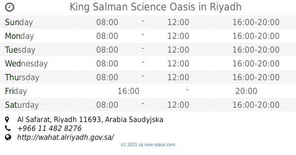
King Salman Science Oasis
Riyadh
Museum
read more
9.818 km
جسر المشاة لتراث الدرعية القديمة
Ad Diriyah
Museum
read more
9.948 km
Najdi Village Administration Building
3353 King Faisal Road, Riyadh
Museum
read more
10.088 km
CAPRIS
Riyadh
Museum
read more
📑
all categories
Accounting
Administrative area level 1
Airport
Amusement park
Aquarium
Art gallery
Atm
Bakery
Bank
Bar
Beauty salon
Bicycle store
Book store
Bowling alley
Bus station
Cafe
Campground
Car dealer
Car rental
Car repair
Car wash
Casino
Cemetery
Church
City hall
Clothing store
Colloquial area
Convenience store
Country
Courthouse
Dentist
Department store
Doctor
Electrician
Electronics store
Embassy
Finance
Fire station
Florist
Food
Funeral home
Furniture store
Gas station
General contractor
Grocery or supermarket
Gym
Hair care
Hardware store
Health
Hindu Temple
Home goods store
Hospital
Insurance agency
Intersection
Jewelry store
Laundry
Lawyer
Library
Light rail station
Liquor store
Local government office
Locality
Locksmith
Lodging
Meal delivery
Meal takeaway
Mosque
Movie rental
Movie theater
Moving company
Museum
Natural feature
Neighborhood
Night club
Painter
Park
Parking
Pet store
Pharmacy
Physiotherapist
Place of worship
Plumber
Point of interest
Police
Political
Post office
Premise
Real estate agency
Restaurant
Roofing contractor
Route
Rv park, camping
School
Shoe store
Shopping mall
Spa
Stadium
Storage
Store
Sublocality
Subpremise
Subway station
Supermarket
Taxi stand
Train station
Transit station
Travel agency
University
Veterinary care
Zoo
sublocality level 1
↑