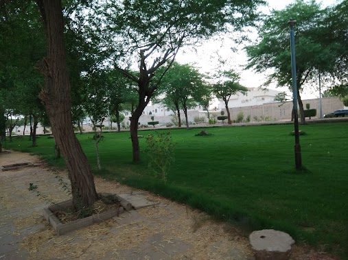
Park nearby Park Racecourse and orchards
Coronavirus disease (COVID-19) Situation
confirmed cases
841469
deaths
9646
Saudi Arabia
Park nearby Park Racecourse and orchards
Park Racecourse and orchards
2896, Khub Al Qabr, Buraydah 52343, Saudi Arabia
contacts phone
:
+966
Latitude:
26.3103107
, Longitude:
44.0210993
larger map & directions
read more
nearest Park
1.442 km
مشتل المحيميد
7859 Khudayra Road, Buraydah
Park
read more
1.616 km
استراحة الصمعاني
4946, Buraydah
Park
read more
1.912 km
Alshurooq Park
Buraydah
Park
read more
2.221 km
Aldahi Park
6362, Buraydah
Park
read more
2.498 km
حديقة دوار الهديه
Buraydah
Park
read more
3.924 km
حديقة الأبراج
Buraydah
Park
read more
3.932 km
منتزه الجرّاد
Eastern Ring Road, Buraydah
Park
read more
4.253 km
Park High for families
4476, Buraydah
Park
read more
4.331 km
حديقة
النقع الغربية،, Buraydah
Park
read more
4.333 km
Alsharq nursery gardens
Buraydah
Park
read more
4.355 km
منتزة الرفيعه عام للجميع
النقع الغربية،, Buraydah
Park
read more
4.373 km
Al Rfyaah Park
Buraydah
Park
read more
4.522 km
شاليه صن رايز
Al Wusayti
Park
read more
5.101 km
حديقة الخليج
3769, Buraydah
Park
read more
5.236 km
استراحة النورس 🌴🏊🏻♂️
6986, 3830, Buraydah
Park
read more
5.246 km
حديقة المضمار
7274 Al Qanat, Buraydah
Park
read more
5.911 km
Al Mouwata Park
Al Mawta
Park
read more
5.946 km
Talents Garden Rotected Birds
Buraydah
Park
read more
6.106 km
مشتل الفاكهة وزارة الزراعة
Buraydah
Park
read more
6.233 km
Alhidyah Park
Buraydah
Park
read more
6.348 km
Muwatta Park
Buraydah
Park
read more
6.629 km
Al Shamas Park
7249 As Sinaah, Buraydah
Park
read more
6.638 km
حديقة
7667 King Abdulaziz Road, Buraydah
Park
read more
6.701 km
Chalet Rose Gardn 2
Buraydah
Park
read more
6.82 km
Green Park الحديقة الخضراء
2931, Buraydah
Park
read more
📑
all categories
Accounting
Administrative area level 1
Airport
Amusement park
Aquarium
Art gallery
Atm
Bakery
Bank
Bar
Beauty salon
Bicycle store
Book store
Bowling alley
Bus station
Cafe
Campground
Car dealer
Car rental
Car repair
Car wash
Casino
Cemetery
Church
City hall
Clothing store
Colloquial area
Convenience store
Country
Courthouse
Dentist
Department store
Doctor
Electrician
Electronics store
Embassy
Finance
Fire station
Florist
Food
Funeral home
Furniture store
Gas station
General contractor
Grocery or supermarket
Gym
Hair care
Hardware store
Health
Hindu Temple
Home goods store
Hospital
Insurance agency
Intersection
Jewelry store
Laundry
Lawyer
Library
Light rail station
Liquor store
Local government office
Locality
Locksmith
Lodging
Meal delivery
Meal takeaway
Mosque
Movie rental
Movie theater
Moving company
Museum
Natural feature
Neighborhood
Night club
Painter
Park
Parking
Pet store
Pharmacy
Physiotherapist
Place of worship
Plumber
Point of interest
Police
Political
Post office
Premise
Real estate agency
Restaurant
Roofing contractor
Route
Rv park, camping
School
Shoe store
Shopping mall
Spa
Stadium
Storage
Store
Sublocality
Subpremise
Subway station
Supermarket
Taxi stand
Train station
Transit station
Travel agency
University
Veterinary care
Zoo
sublocality level 1
↑