Pharmacy nearby Malak Pharmacy
Saudi Arabia
Pharmacy nearby Malak Pharmacy
Malak Pharmacy
6372 Unayzah Street, Riyadh Arabia Saudita
contacts phone
:
+966
Latitude:
24.6980681
, Longitude:
46.781184
read more
nearest Pharmacy
105 m
صيدلية الرشاد
Unayzah Street, Riyadh
Pharmacy
read more
113 m
صيدلية أطلس الجزيرة
Riyadh
Pharmacy
read more
302 m
Al-Dawaa
شارع عنيزة، الروابي، الرياض
Pharmacy
read more
507 m
Nahdi
Unayzah Street, Riyadh
Pharmacy
read more
647 m
Al-Rayyan District Pharmacy
Riyadh
Pharmacy
read more
703 m
صيدلية كنوز الصحة
Unayzah Street, Riyadh
Pharmacy
read more
710 m
صيدلية دان المضيئة
3984 Al-Imam Ahmad Bin Hanbal Street, Riyadh
Pharmacy
read more
724 m
Missned Pharmacy
Unayzah Street, Riyadh
Pharmacy
read more
856 m
صيدلية قطرة الشفاء الطبية
شارع عبدالله بن عباس، الرياض
Pharmacy
read more
954 m
صيدلية العناية بالجلد
الطريق الدائري الشرقي - حي الربوة، الرياض
Pharmacy
read more
963 m
صيدلية الديار
7291 Unayzah Street, Riyadh
Pharmacy
read more
964 m
صيدلية الحياة
شارع الدائري الشرقي ، حي المنار، الرياض
Pharmacy
read more
965 m
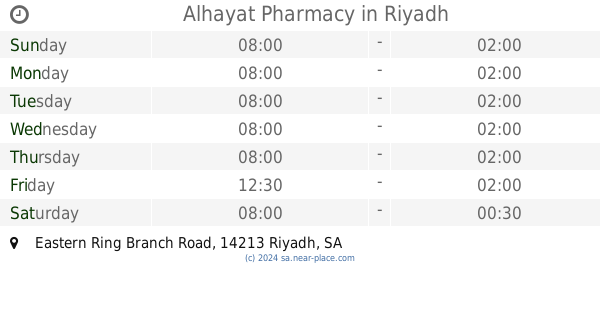
Alhayat Pharmacy
Eastern Ring Branch Road, Riyadh
Pharmacy
read more
987 m
Al Nahdi Pharmacy
3621 Az Zubair Ibn Al Awam, Riyadh
Pharmacy
read more
1.006 km
صيدلية ركن زهرة الروضة
Riyadh
Pharmacy
read more
1.177 km
Al-Dawaa
Az Zubair Ibn Al Awam, Riyadh
Pharmacy
read more
1.309 km
BOON PHARMCY
4394 Umar Ibn Abdul Aziz Branch Road, Riyadh
Pharmacy
read more
1.33 km
صيدلية بون - الربوة
4420 Umar Ibn Abdul Aziz Branch Road, Riyadh
Pharmacy
read more
1.376 km
Al-Anaya Al-Dawaiya
الزبير بن العوام Az Zubair Ibn Al Awam, Riyadh
Pharmacy
read more
1.39 km
Al-Dawaa pharmacy
Al-Imam Ahmad Bin Hanbal Street, Riyadh
Pharmacy
read more
1.416 km
صيدلية زهرة الروضة
Prince Majed Bin Abdulaziz Road, Riyadh
Pharmacy
read more
1.455 km
صيدلية
Riyadh
Pharmacy
read more
1.492 km
صيدلية معادن
شارع الدائري الشرقي الفرعي، حي الربوة، الرياض
Pharmacy
read more
1.504 km
صيدلية
7384 Ath Thawimat, Riyadh
Pharmacy
read more
1.505 km
وايتس
7384 Ath Thawimat, Riyadh
Pharmacy
read more
📑
all categories
Accounting
Administrative area level 1
Airport
Amusement park
Aquarium
Art gallery
Atm
Bakery
Bank
Bar
Beauty salon
Bicycle store
Book store
Bowling alley
Bus station
Cafe
Campground
Car dealer
Car rental
Car repair
Car wash
Casino
Cemetery
Church
City hall
Clothing store
Colloquial area
Convenience store
Country
Courthouse
Dentist
Department store
Doctor
Electrician
Electronics store
Embassy
Finance
Fire station
Florist
Food
Funeral home
Furniture store
Gas station
General contractor
Grocery or supermarket
Gym
Hair care
Hardware store
Health
Hindu Temple
Home goods store
Hospital
Insurance agency
Intersection
Jewelry store
Laundry
Lawyer
Library
Light rail station
Liquor store
Local government office
Locality
Locksmith
Lodging
Meal delivery
Meal takeaway
Mosque
Movie rental
Movie theater
Moving company
Museum
Natural feature
Neighborhood
Night club
Painter
Park
Parking
Pet store
Pharmacy
Physiotherapist
Place of worship
Plumber
Point of interest
Police
Political
Post office
Premise
Real estate agency
Restaurant
Roofing contractor
Route
Rv park, camping
School
Shoe store
Shopping mall
Spa
Stadium
Storage
Store
Sublocality
Subpremise
Subway station
Supermarket
Taxi stand
Train station
Transit station
Travel agency
University
Veterinary care
Zoo
sublocality level 1
↑