School nearby المتوسطة الأولي بنات
Saudi Arabia
School nearby المتوسطة الأولي بنات
المتوسطة الأولي بنات
الملك سعود, Taif Saudi Arabia
contacts phone
:
+966
Latitude:
21.2842685
, Longitude:
40.418205
read more
nearest School
145 m
School Farouk Mediterranean
Taif
School
read more
145 m
School Tiles Martyrs Elementary Boys
2563 King Saud, Taif
School
read more
158 m
الثانوية الحادية والثلاثون للبنات
Okaz, Taif
School
read more
159 m
31th Secondary School for Girls
Taif
School
read more
246 m
King Abdulaziz School
Abu Bakr As Siddiq, Taif
School
read more
277 m
مدرسة الإمام حفص
7826 Abu Bakr As Siddiq, Taif
School
read more
294 m
Boys Special Education Institute
Abu Bakr As Siddiq, Taif
School
read more
342 m
Imam Asim School for the memorization of the Koran
Taif
School
read more
345 m
Sufyan bin Abdullah Althagafi Elementary School
2507 ADH Dhahran, Taif
School
read more
560 m
متوسطة أبي محجن الثقفي
7387 Shubra Street, Taif
School
read more
560 m
Abdul Aziz Bin Muammar Intermediate School
7850, Taif
School
read more
571 m
ادارة خدمات خدمات الطلاب النسائية
Taif
School
read more
578 m
The Ministry of Education - the education of girls
7626 Wadi Waj Road, Taif
School
read more
594 m
مدرسه الابتداءيه الاربعون
Unnamed Road, Taif
School
read more
642 m
الثانوية السادسة مقررات
6950 Dammam, 3106, Taif
School
read more
660 m
hi
Abu Horyra, Taif
School
read more
666 m
متوسطة المعالي الاهلية
5221 العقيق، العزيزية، الطائف 26522
School
read more
712 m
Alsun Language Center
Taif
School
read more
759 m
مدرسة الخمسون المتوسطة
3694, Taif
School
read more
759 m
Khwarizmi Institute
Shubra Street, Taif
School
read more
767 m
Dar Khadija for the memorization of the Koran
5096 Al Aqiq, Taif
School
read more
773 m
روضة طيور الجنه
Tur Saina, Taif
School
read more
808 m
Elementary Wael Ben Stone
5101, Taif
School
read more
843 m
مدرسه العقيق الثانويه
7939, Taif
School
read more
863 m
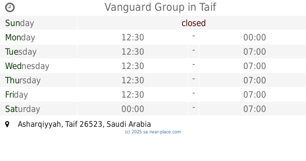
Vanguard Group
Taif
School
read more
📑
all categories
Accounting
Administrative area level 1
Airport
Amusement park
Aquarium
Art gallery
Atm
Bakery
Bank
Bar
Beauty salon
Bicycle store
Book store
Bowling alley
Bus station
Cafe
Campground
Car dealer
Car rental
Car repair
Car wash
Casino
Cemetery
Church
City hall
Clothing store
Colloquial area
Convenience store
Country
Courthouse
Dentist
Department store
Doctor
Electrician
Electronics store
Embassy
Finance
Fire station
Florist
Food
Funeral home
Furniture store
Gas station
General contractor
Grocery or supermarket
Gym
Hair care
Hardware store
Health
Hindu Temple
Home goods store
Hospital
Insurance agency
Intersection
Jewelry store
Laundry
Lawyer
Library
Light rail station
Liquor store
Local government office
Locality
Locksmith
Lodging
Meal delivery
Meal takeaway
Mosque
Movie rental
Movie theater
Moving company
Museum
Natural feature
Neighborhood
Night club
Painter
Park
Parking
Pet store
Pharmacy
Physiotherapist
Place of worship
Plumber
Point of interest
Police
Political
Post office
Premise
Real estate agency
Restaurant
Roofing contractor
Route
Rv park, camping
School
Shoe store
Shopping mall
Spa
Stadium
Storage
Store
Sublocality
Subpremise
Subway station
Supermarket
Taxi stand
Train station
Transit station
Travel agency
University
Veterinary care
Zoo
sublocality level 1
↑