School nearby الروضه العاشره
Saudi Arabia
School nearby الروضه العاشره
الروضه العاشره
7335 ابن المهلهل, Tabuk Saudi Arabia
contacts phone
:
+966
Latitude:
28.4230758
, Longitude:
36.5173078
read more
nearest School
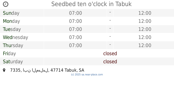
Seedbed ten o'clock
7335 ابن المهلهل, Tabuk
School
read more
48 m
المتوسطة التاسعة والعشرون بنات
Tabuk
School
read more
73 m
Primary Forty Girls
Tabuk
School
read more
243 m
Kindergarten imprint of hope for Special Education
7161 ابن المهلهل, Tabuk
School
read more
249 m
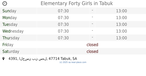
Elementary Forty Girls
4391 الحسن بن سهل, Tabuk
School
read more
387 m
Zubair bin Awam Elementary Boys
Tabuk
School
read more
486 m
Secondary Umm Al Qura
عبدالرحمن الخزرجي, Tabuk
School
read more
521 m
روضة بشائر العلم الاهلية
Prince Abdulrahman Bin Faisal Road, Tabuk
School
read more
526 m
مدرسه عين جالوت
القادسية 1،, Tabuk
School
read more
548 m
Kindergarten promise of science
4024, القادسية، 6761, Tabuk
School
read more
712 m
Secondary Twenty Two Girls Tabuk
Unnamed Road, Tabuk
School
read more
936 m
الابتدائية الثالثة والستون
3481, القادسية، 7958, Tabuk
School
read more
1.092 km
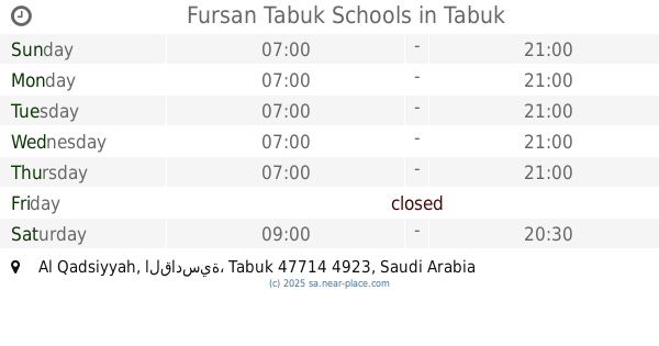
Fursan Tabuk Schools
8069, Al Qadsiyyah, Tabuk
School
read more
1.099 km
مدرسة فرسان
8109, Tabuk
School
read more
1.111 km
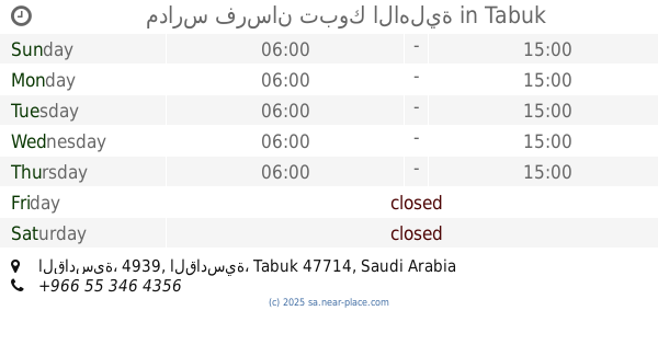
مدارس فرسان تبوك الاهلية
8080, القادسية، 4939, Tabuk
School
read more
1.133 km
مدرسة عبدالله بن مسعود الابتدائية تبوك
3248, القادسية، 8040, Tabuk
School
read more
1.159 km
الروضة الثالثة عشر
8152 Sahl Ibn Iyad, Tabuk
School
read more
1.259 km
متوسطة عمير بن ابي وقاص
3162, 8006, Tabuk
School
read more
1.264 km
ابتدائية الحسن البصري رحمه الله
Abdullah Al Makhzumi, Tabuk
School
read more
1.286 km
مدرسة الحسن البصري
8056 Sahl Ibn Iyad, Tabuk
School
read more
1.3 km
Secondary Abu Musa Ash'ari
Al Farabi, Tabuk
School
read more
1.306 km
Mutah elementary boys
Tabuk
School
read more
1.311 km
Secondary Buhturi
Tabuk
School
read more
1.342 km
Private School for Autism
8526, Tabuk
School
read more
1.369 km
Medium Asaad bin Zaraarah
Tabuk
School
read more
📑
all categories
Accounting
Administrative area level 1
Airport
Amusement park
Aquarium
Art gallery
Atm
Bakery
Bank
Bar
Beauty salon
Bicycle store
Book store
Bowling alley
Bus station
Cafe
Campground
Car dealer
Car rental
Car repair
Car wash
Casino
Cemetery
Church
City hall
Clothing store
Colloquial area
Convenience store
Country
Courthouse
Dentist
Department store
Doctor
Electrician
Electronics store
Embassy
Finance
Fire station
Florist
Food
Funeral home
Furniture store
Gas station
General contractor
Grocery or supermarket
Gym
Hair care
Hardware store
Health
Hindu Temple
Home goods store
Hospital
Insurance agency
Intersection
Jewelry store
Laundry
Lawyer
Library
Light rail station
Liquor store
Local government office
Locality
Locksmith
Lodging
Meal delivery
Meal takeaway
Mosque
Movie rental
Movie theater
Moving company
Museum
Natural feature
Neighborhood
Night club
Painter
Park
Parking
Pet store
Pharmacy
Physiotherapist
Place of worship
Plumber
Point of interest
Police
Political
Post office
Premise
Real estate agency
Restaurant
Roofing contractor
Route
Rv park, camping
School
Shoe store
Shopping mall
Spa
Stadium
Storage
Store
Sublocality
Subpremise
Subway station
Supermarket
Taxi stand
Train station
Transit station
Travel agency
University
Veterinary care
Zoo
sublocality level 1
↑